
Stravaiging: 'wandering aimlessly'. Not today though, you'll be exploring a part of South Edinburgh that is rich in history but nowadays largely forgotten. There are so many places of interest that I've had to be really selective, otherwise it would take you too long. My apologies therefore to the places omitted.
St Leonard's: a mainly residential area of south Edinburgh, but once a centre of industry, ecclesiastical activity, and political intrigue; and also the Jewish Quarter of Edinburgh. It forms that part of the Southside that lies on the east side of the A701, with Salisbury Crags and Arthur's Seat to the east, Dumbiedykes and the Old town to the north, and Prestonfield to the south. The land around here was first owned by the monks of Holyrood Abbey, and was given to them by King David. The most obvious landmark is of course Arthur's Seat and the Salisbury Crags, forming the centrepiece of Holyrood Park, also known historically as the King's Park; and from 1953 to 2022, Southsiders have called it the Queen's Park. I presume we will go back to calling it the King's Park again? Anyway, the park has always been a 'royal' park and was enclosed as such in the 16th century. Here, on the west side of the crags, is a hill called St Leonard's Hill, named for the chapel built on it around 1493 by order of the Abbot of Holyrood. The arrival of St Leonard's Chapel and Hospital paved the way for a small village community to grow around it which expanded and thrived right up till the mid 20th century; in addition to the expected agricultural and manufacturing uses, there was also Nelson Printmakers; distilling; the Edinburgh-Dalkeith railway; and part of St Leonard's became known as the 'Jewish' quarter of Edinburgh. The major road running through St Leonard's is The Pleasance, which runs north to south from the Flodden Wall, which was built in a panic in case of further attacks by the English; (see my Adventure Lab 'Follow the Flodden Wall'). The name is often erroneously ascribed to Saint Mary of Placentia; but it simply means a park or garden and was the name of a house that first appears on maps in the year 1507. The closure of the railway and the printworks led to redevelopment which changed the nature of the area to the more residential one we see nowadays.
This multi is the 11th of 12 local history multis set in South Edinburgh. Keep a note of your answers as you go, you will need them for the bonus. My other multicaches about local history are:
There are twelve southside local history caches, and 2 bonus mystery caches:
First series: Gambol Through the Grange Second series: Sally into the Southside
Meander Through Marchmont Knocking around Newington
Saunter Through Sciennes Toddle Around Tollcross
Bimble Through Blackford Footerin' Aboot in Fountainbridge
Birl Through Bruntsfield Perambulate through Prestonfield
Mosey Through the Meadows Stravaiging around St Leonard's
There is a bonus mystery cache for the first series: Jig Through Half a Dozen History Multis
There is a bonus mystery cache for the second series: Jig Through another Half a Dozen multicaches
Let's begin our tour at the obvious starting point, the site of St Leonard's Hospital. You can of course walk the route in any order you like, but the route given will bring you to a place to sit down and not very far from the final location. There are many places to eat around and about. Peedieduchess confirms that whole route can be done by bicycle, and probably wheelchair users can also do it, but may require assistance to retrieve the cache itself. The Duke and Duchess can walk the route in under an hour. Good luck!
IT IS ABSOLUTELY ESSENTIAL THAT YOU TAKE TWEEZERS WITH YOU FOR THE LOG BOOK RETRIEVAL PLEASE
Waypoint 1: St Leonard's Hospital N 55° 56.613' W 3° 10.635

Here is the site where St Leonard’s Hospital and Chapel once stood, and gave the name to this district. It was probably built around 1493 on the orders of Abbot Robert Bellenden of Holyrood Abbey. If you stand by the gate, you can get an impression of how the land lies: this hill lies on the west side of Holyrood Park, separated from Salisbury Crags by Queen's Drive.
The hospital and chapel belonged to Holyrood Abbey but there are records of an earlier hermitage as far back as the 13th century; this would be a place of refuge for travellers who had not managed to reach the city gates before they were closed at nightfall. The hospital housed 6 elderly destitute men but it is worth noting that in those days a ‘hospital’ was not necessarily a place of healing with doctors and nurses as we now know it; it was a sort of almshouse, a place of refuge and welcome, and also of teaching. (hence the word ‘hospitality’). These 'hospitallers' had to pay for their board and lodging by agreeing to say prayers throughout the day. It was also the site of political intrigue: members of the Douglas clan met here in 1528 to conspire to murder King James V. Their plan was to proceed from St Leonard's Chapel to Holyrood Palace and climb in through the King’s bedroom window to murder him. However, their plan was discovered and thwarted in time.
In 1650 the hill was held against Cromwell’s forces by Colonel Lawers.
I found this description about it: Cromwell's army had been repelled, but tried again to enter the city:
“Encircling Arthur’s Seat, a strong column of infantry, a brigade of cavalry, and two pieces of cannon attempted to enter the city by the southern road that led from the Pleasance. On this Campbell of Lawers brought his regiment of musketeers at double-quick march up the glen by the base of Salisbury Craigs to the ruins of St. Leonard’s chapel, and taking an alignment behind the hedges and walls of the King’s Park, poured from thence a deadly fire, which drove back the infantry in disorder. They threw aside their muskets, pikes, and collars of bandoliers, and fled, abandoning their cannon, which were brought by the horse brigade.”
James Clark School The walls of the chapel were demolished around 1854, when many skeletons were found. ‘Clarkies’ was built on the site of the old hospital in 1913, and is now converted into flats.
This James Clark was a Deputy Lieutenant of the city who commanded the 9th Battalion of the Argyll and Sutherland Highlanders in WWI, he was killed in action in 1915.
If you feel like a walk, you can go through the gate here and descend to Queen's Drive, and up Arthur's Seat.
Question to Answer: The waypoint is next to an entrance to the park. There is also a lamp post here with 5 letters on it. Take the second letter, convert it to a number and double it to get C
Waypoint 2: St Leonard’s Station N55° 56.589' W003° 10.676

The coordinates bring you near the entrance of the Holyrood Distillery and a building which was once the goods shed for St Leonard’s Station. A red plaque, or ‘Transport Wheel’ was placed on the wall by the National Transport Trust to indicate the importance of this railway line to the history of transport.
This railway opened in 1831 and ran from Dalhousie Mains, near Dalkieth, almost 9 miles away, with branch lines off to Fisherrow and Leith Docks. The railway was built by coal mine owners themselves through a consortium led by the Duke of Buccleuch and its main purpose was to carry coal from the Dalkeith coal mines into the city; the 4’6” gauge was chosen to match that of the wagons in the coal pits. They bought land in the King’s Park because it was available and cheap; and appointed architect James Jardine to design it. The route is mainly flat until it reaches the foot of Salisbury Crags, where Jardine encountered the problem of having to get through very hard volcanic rock. And so Scotland’s very first railway tunnel was made by boring through the rock: St Leonard’s Tunnel is 518m long and has an incline of 1 in 30.
At that time, in the early 19th century, steam power was only just becoming known and people were still suspicious of it and thought it was dangerous; the Dalkeith to St Leonard’s railway wagons were therefore horse drawn, except for some assistance through the tunnel with a steam engine and ropes.
As a privately owned railway, although it was built for coal wagons, it wasn’t long before businessmen purchased passenger carriages and paid a fee to use the line; and landowners also construced their own private branch lines, notably The Marquis of of Lothian Waggonway which ran on a timber viaduct over the river Esk, and was essential for the economy of the village of Newtongrange, and the Arniston Branch which also had a viaduct over the Esk, this time made of steel and concrete.
Of course the age of steam caught up, and the railway was taken over by the North British Railway Company. It closed to passengers in 1847, and finally closed for goods in 1968 with the closure of the last MidLothian coal mine.
The tunnel is known locally as the Innocent Railway Tunnel and now carries a very popular walking and cycling path. The entrance is very close to where you are standing, just walk a little way east along the path. Why is it called ‘Innocent’? Well, I’d like to think that it was because no-one died during the construction work; but that would be wrong. It's actually because it didn’t use steam, to begin with anyway, it retained the 'innocence' and simplicity of horse-drawn wagons.
Youtube video of the last train journey
The railway features in a Scotsman newspaper daily novel, ‘Edward Kane and the Innocent Railway’.
Question to Answer: Examine the red plaque, and also the drain inspection cover you are standing on. Add: (last digit of the year they stopped hauling the carts with horses and ropes) to (the number of footprints) = F
Waypoint 3: Jeanie Dean's Tryst N55 56.605 W003 10.695
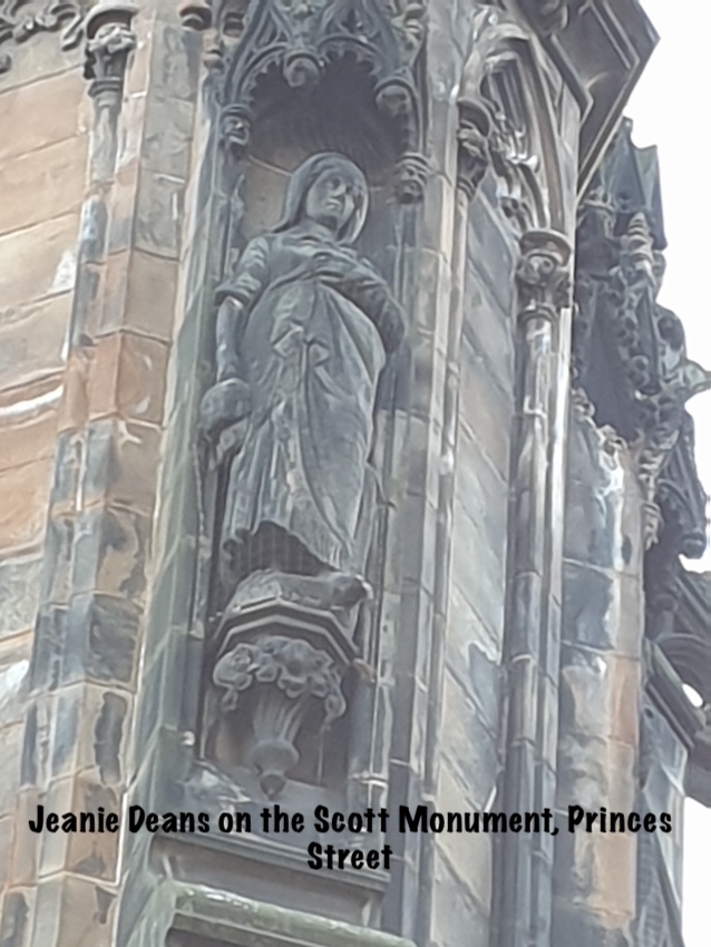
From the entrance to Holyrood Distillery, look across St Leonard's Bank to see a stone engraving on the wall 'Jeanie Deans Tryst'. The one you need however is at the waypoint round the corner in St Leonard's Hill, above a pub called the Tipsy Midge. You may see it more easily from across the road. Jeanie Deans was a character in the novel Heart of MidLothian by Sir Walter Scott. Jeanie was a saintly person, honest, religious, an upstanding example to the community. She walked barefoot all the way to London to help her sister who had been wrongly accused of murdering her baby. Her character was based on a real woman called Mrs Helen Lawrence Goldie of Dumfries. The original cottage where Jeanie was supposed to live is long gone.
There is a sculpture of Jeanie on the Scott Monument in Princes St.
As a curious piece of random information for you: did you know that the North British Railway Company owned a fleet of paddle steamers with names from Sir Walter Scott’s novels? One of them was called the Jeanie Deans and there’s a lovely song about her by the Battlefield Band:
The Bonny Jeanie Dean
Her sister ships had names also taken from the novels of Sir Walter Scott, such as the Waverley, the Lucy Ashton (from the Bride of Lammermoor) and the Talisman. Only the PS Waverley is still paddling around the Clyde.
Question to Answer: Add up the number of visible legs/feet to get clue D
Waypoint 4: Hermits and Termits N 55 56.522 W003 10.712

This waypoint brings you to a wellhead outside a beautifully restored 18th century house. It is now a private residence so please don’t disturb them.
The initials above the door, C, W and M, refer to William and Mary Clifton, the original owners in 1734. In 1807 an engraver called Robert Scott rented the house and he had the well installed outside, with the date 1815 to commemorate the battle of Waterloo.
In 1827 the house was bought by the Edinburgh and Dalkeith Railway to use as their office and became known for a time as ‘Coalyard House’.
The name Hermits and Termits comes from the names of 2 crofts that were built in the grounds of St Leonard’s Chapel. Le Hermitis Croft is named for Leonard of Noblac, a French hermit, and patron saint of prisoners who died in 559. He gained that particular honour along with the nickname ‘breaker of chains’ because it was thought that if a prisoner looked at him with sufficient faith, their chains would fall off and they would be free. Le Terraris Croft is named for TERRAR: a sort of caretaker person who managed the lands that belonged to Holyrood Abbey on behalf of the monks. Those of you who learnt Latin at school will recognise the word 'terra' which means earth or land. I like to imagine that these were 2 lovely, cosy picturesque cottages, which likely had great views to the west, unobstructed by the tenements of Newington and Grange.
The names are now preserved in the house and also 2 streets nearby with modern homes, named Hermits Croft and Terrars Croft. I'm not sure why the house is 'Termits' rather than 'Terrars' other than it rhymes!
Question to Answer: Subtract the number of keyholes in the wellhead from the number of surrounding trees to get E
As you walk down The Pleasance, keep an eye open for Hamilton's Folly Mews: there is nothing much to see there, the Folly is no longer there, but it was a very elaborate 3 storey house with ornate archways and so on. Hamilton built it in 1709 and was much ridiculed for his folly, owing to it being so close to the gibbet, which you can see on the background map. The bodies of hanged criminals would probably have been still hanging for days.
Waypoint 5: East Crosscausway N 55° 56.636' W 3° 10.910

The waypoint brings you to a wellhead in East Crosscauseway, which was one of the main Southside thoroughfares. As the name suggests, it crosses over Causewayside, linking the two ancient routes out of Edinburgh, Causewayside and Pleasance. Later, the 'Crosscausey' was split into East and West sections by the building of a third main route, the A7. The name 'causeway' is nothing to do with roads built up across a body of water: it is from a Norman French word, 'causée' which means 'paved'. Along with nearby streets such as Richmond St, Nicolson St, St Leonard’s St, Davie St and the Pleasance, this was the old Jewish Quarter. In the early 19th Century, it was already home to a small number of immigrant Jews from Eastern Europe, but then following the assasination of Tsar Alexander II in 1881, many more came by ship to Leith to escape the pogroms. They were well integrated with the local population, and although the wretched slum tenements they lived in are mostly gone now, local southsiders even today remember that there were at least 4 Kosher butcher shops and several bakers. Kleinberg bakery was open from the start of the 20th century and ran as a family business until 2003. The recipe for challah bread was given to the Breadwinner Bakery by Arthur Kleinberg when he retired in his 90s.
It seem unlikely that this wellhead was part of the main city water supply that ran from Comiston Springs to Edinburgh Castle Esplanade under gravity; it seems more likely that it's a stand-alone well for the use of local residents.
Question to Answer: The wellhead has inscriptions on 2 of its sides. Add the number of ‘1s’ to the number of ‘7s’ to get clue A
Waypoint 6 Deaconness Garden N55 56.736 W003 10.947

You should be standing near an information board in this small park, from here you can look over the road to the site of Deaconess Hospital and St Ninians Mission, with Salisbury Crags behind.
The role of Deaconess in some Protestant and Orthodox Christian churches is of a woman who is not ordained as a minister, but who provides advice and support to the congregation, particularly the women and families. They have existed since the time of Jesus.
The mission was established by Professor Archibald Charteris, former moderator of the General Assembly of the Church of Scotland and founder of the Woman’s Guild, in 1894. He bought the house from Lord Carnegie, and a few years later he also opened the Deaconess Hospital, originally intended to train some of the deaconesses as nurses to prepare them for their missionary work. The hospital was taken over by the National Health Service in 1948 and closed in 1990.
On the other side of the mission, a new church was built called Charteris Memorial; it later amalgamated with Pleasance Church, then Newington Church and some others, and is now linked with Greyfriars Church, Tolbooth and Highland to form Kirk o’ Field.
The whole complex of the old Charteris Church and St Ninian’s Mission is now called the Greyfriars’ Charteris Centre.
Peedieduchess worked in the hospital as a visiting trainee anaesthetist in the early 1980s; she recalls meeting one of the senior surgeons for the first time; she entered by a side door, which had stairs up to the wards; as she ascended the stairs, this surgeon was on the way down; he was wearing a kilt……..
The main hospital building has been converted into student accommodation now.
Question to Answer: You will find this answer on the information board. It tells us there are spectacular views of something: how many letters in the first word of this thing? This will give you clue B
There are seats in the park where you can rest for a bit and admire the view while calculating where the final cache location is.
The final location is N55 56.ABC W003 10.DEF
Would you like a checksum? your 6 numbers should add up to 39
You may also use this checker:

THE FINAL LOCATION IS A HIGH MUGGLE AREA: PLEASE BE SCRUPUOUSLY STEALTHY. PLEASE REMOVE THE LOG PAPER VERY CAREFULLY AND USE TWEEZERS.