
------------oOo------------
[FR]
Afin de trouver les coordonnées exactes de la cache, je vous propose de traverser l’histoire de Châtillon en découvrant quelques témoignages architecturaux qui sont parvenus jusqu’à nous. Une balade comprise entre 30 mn et 1 heure (suivant votre rythme) sur 2,3 km vous rappellera deux éléments qui ont fortement marqué l'histoire de Châtillon : la vigne et les religions.
Trois caches traditionnelles et une adventure lab sont également accessibles sur le parcours.
Petit parking conseillé, rue du Château Gaillard, en contrebas de l'église et des ruines du château (Voir way point)
Point de départ : N 47°35,355' / E 2°45,016'.
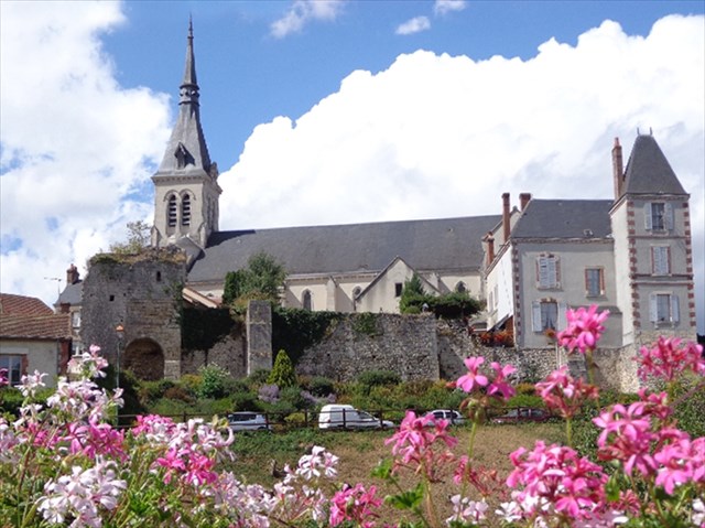
La tradition fait remonter au VIe siècle l’installation, à Nancray, d’un jeune prêtre, Saint Posen, qui rassemble autour de lui les habitants disséminés jusque-là dans les campagnes. Au IXe siècle, le Roi fait don aux moines de l’abbaye de Fleury (Saint-Benoît) des terres de Nancray ; les moines fondent un petit monastère. Au siècle suivant, sur la colline où est située l’église actuelle, s’établit une petite forteresse, un « castellio » (qui donnera son nom à Châtillon) à l'emplacement de l'église actuelle.
Pour parvenir au sommet de cette colline, emprunter l'escalier qui monte du pied des ruines du château (à droite du N° 4 rue du Château Gaillard).
IMPORTANT : les personnes à mobilité réduite ou avec une poussette peuvent rejoindre la place de l'église en contournant l'édifice par la droite.
Place forte protestante, la ville est attaquée ou assiégée sept fois entre 1560 et 1590. Un premier Temple est édifié et l’église détruite en partie par les protestants. La lutte idéologique se poursuit au cours du XVIIe siècle. Richelieu finance la reconstruction de l’église (1627), tandis que des “affaires” entre catholiques et protestants déchaînent les passions. Le premier temple fut détruit à la suite d’un ordre venu de Versailles, en 1684, un an avant la révocation de l’édit de Nantes. Jusqu’en 1786, les protestants ne peuvent plus célébrer leur culte que dans la clandestinité.
Sur la place de l’église (WP1), compter le nombre de colonnes en pierre qui entourent le porche.
>>> Noter ce chiffre A = _
Sur la place de l'église se trouve une croix qui porte une date. Relever le dernier chiffre de cette date.
>>> Noter ce chiffre B = _
Emprunter la rue à gauche (rue du cimetière) jusqu’au n° 14 (WP2) : la maison située au fond de la cour abritait des réunions clandestines protestantes au milieu du XVIe siècle. Compter le nombre total de pics que comporte la grille devant la maison (pic principal y compris : nombre pair).
>>> Noter ce nombre C = _ _
Après cette maison, avancer dans la ruelle à droite : belle tour du XVe siècle à gauche.
Faire demi-tour et revenir vers l’église en admirant, sur la droite, les descentes de cave des maisons vigneronnes. De l’époque médiévale, nous remontent plusieurs descriptions qui font état de la « surabondance de vignes ». Dès l’installation des moines dans le val de Nancray, jusqu’à la moitié du XXe siècle, Châtillon peut être considéré comme un pays dont la vigne procurait un revenu important à sa population.
Ce cadre bucolique a connu une histoire mouvementée. Jusqu’au XIIIe siècle, il est l’enjeu de luttes entre puissances rivales : Abbaye de Fleury, seigneurs de Sully et comtes de Sancerre.
Passer à nouveau devant la croix et compter le nombre de bornes en pierre carrées qui l'entourent.
>>> Noter ce chiffre : D = _
Se diriger vers la rue Gelée, à gauche. Avant de la descendre, admirer la maison sur la droite dont une partie date du Moyen Âge, l’autre partie de la Renaissance.
En bas de la rue Gelée, vous noterez un curieux chalet en bois au N° 16. Continuer en longeant la rivière à gauche par la rue Saint-Posen jusqu’au pont sur la rivière Ethelin. Sur la gauche, au N°19, une maison de tonnelier du début du XXe siècle arbore son écusson gravé dans la pierre.
En franchissant le pont vous entrez dans le faubourg de Nancray. Remarquer le linteau de la maison à droite au N°2 (hotte de raisin, 1909). Poursuivre jusqu’au puits. Vous arrivez au WP3. (cache GC5B92M "Pas de raisins VERTs à Nancray")
Tourner à gauche dans la rue Saint-Vincent, entièrement bordée de maisons de vignerons. L’habitation du n°38 porte une date gravée dans la pierre de l’escalier. Relever cette date et additionner tous les chiffres.
>>> Noter le nombre ainsi obtenu E = _ _
Aux Nos 21/23, se dresse une maison du XVIe siècle dont l’architecture est typique de la région : la partie habitable n’est pas au rez-de-chaussée, on y accède par un escalier extérieur sous lequel est située la cave.
Faire demi-tour, repasser devant le puits pour rejoindre, à gauche avant le pont, le Chemin du Pâtis.
Passer devant le lavoir et la Villa Bagatelle, toute bleue. Au pied de la passerelle en bois sur l’Ethelin, coule (sauf en période de sécheresse !) la fontaine Saint-Posen qui a jaillit, selon la légende, sous les sabots des bœufs qui transportaient le corps du Saint défunt (cache GC52ZGB Fontaine St Posen : des VERTus miraculeuses) .
Poursuivre le long de la rivière, jusqu’à la Place du Champ de foire. Traverser la rivière en remarquant, à gauche, un lavoir (WP4) de la fin du XIXe. Compter le nombre de piliers en bois supportant le toit du lavoir.
>>> Noter ce chiffre F = _
Emprunter la rue des prés, à gauche. Poursuivre jusqu’à la boulangerie (WP5). Remarquer en face de la boulangerie, au N°4, la belle façade Renaissance Italienne classée et ses médaillons. Combien y a-t-il de médaillons en façade ?
>>> Noter ce chiffre G = _
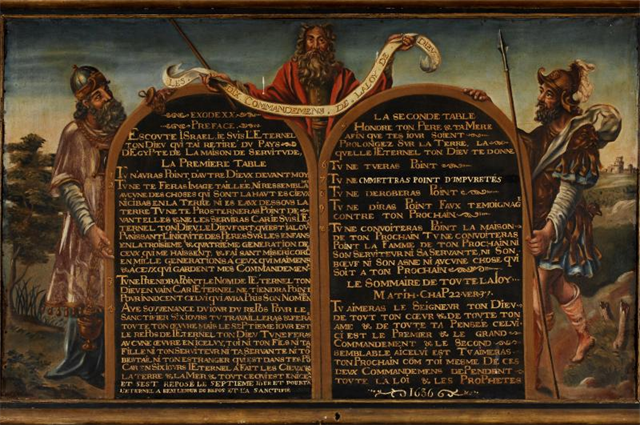
Vous pouvez poursuivre si vous le souhaitez jusqu’à la mairie pour voir, face à l’Office de tourisme, entre les Nos 26 et 28, le temple protestant. Il était, au XIIe siècle, la “Grange-aux-dîmes” des moines l’abbaye de Fleury (Saint-Benoît) dont l’abbé était seigneur de Châtillon. Il renferme un précieux décalogue (WP6). Revenir sur vos pas jusqu'à la boulangerie.
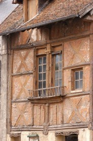
A la boulangerie, emprunter la Rue Haute, l’une des plus anciennes de Châtillon. Remarquer la tour en pans de bois au N°10 et l’architecture de très anciennes maisons, aux Nos 14, 17 et 25. Au N° 11 bis, sur le linteau, déchiffrer le nom du propriétaire, Bizot ainsi qu'une date. Relevez le dernier chiffre de la date pour obtenir la valeur H.
Noter ce chiffre H = _
Prendre à gauche la rue du Château Gaillard, avant l'église. La maison qui fait l'angle (N°1, WP7) porte une gravure du même Bizot et une autre date dont le dernier chiffre est H-1.
Vous repasserez devant votre emplacement de stationnement et franchirez le pont.
Vous arrivez au petit square (WP8) : N 47°35,339' / E 02°45,075'.
Félicitations, vous venez de terminer le parcours. Mais, comme vous l'indiquera avec humour le panneau, vous n'êtes pas exactement à l'endroit de la cache : les moldus pourraient vous apercevoir ! Il est maintenant temps de rejoindre le lieu exact de la cache (très proche) en remplaçant les lettres par les chiffres glanés lors de votre randonnée.
Emplacement exact de la cache : N 47°(C+5),(A-1)2G' / E 02°(C+D+E),(H-9)F(B/2)'
Pourquoi "VERT" ?
Ma première cache posée était une boîte verte, avec un stylo vert, un log book vert et des objets d'échange verts. Ainsi est née l'idée de placer les caches qui ont suivi sous le signe du "VERT" et de proposer un challenge consistant à y déposer de préférence des objets "VERTs". Ce challenge ne peut malheureusement pas concerner les caches de taille nano ou micro.
 Sur le circuit
[EN]
To find the exact address of the cache, I suggest you to browse through the history of Châtillon by discovering some architectural testimonies which reached up to us. A walk during between 30' and 1 hour (depending of your rhythm), on 2,3 km, will remind you two elements which strongly marked the history of Châtillon: the vineyard and the religions.
Three traditional geocaches and one adventure lab are also accessible along the walk.
Starting point: N 47°35,355 ' / E 2°45,016 '.
Parking places recommanded, rue du Château Gaillard, at the bottom of the church and the ruins of the castle
The tradition dates back to the 6th century the establishment at Nancray of a young priest, Saint Posen, who gathered together the inhabitants until then scattered through the countryside. At the start of the 9th century, the King makes donation of the land of Nancray to the monks of Fleury Abbey (Saint Benoît); a small monastery is founded. During the next century, a small fortress – a “castellio”, (hence Châtillon) - is established on the hill where is located the nowadays church.
To reach up to the top of this hill, take the stairs which rises from the foot of the ruins of the castle (on the right of n° 4 rue du Château Gaillard).
IMPORTANT: the people with reduced mobility or with a stroller can join the square of the church by by-passing the building by the right.
As a protestant fortified town, the city is attacked or besieged seven times between 1560 and 1590. A first church is erected and the church is partially destroyed by the Protestants. The ideological struggle went on during the 17th century. Richelieu finances the rebuilding of the church (1627), whereas "affairs" between Catholics and Protestants unleashed passions. The first Protestant church was destroyed by an order come from Versailles, in 1684, one year before the revocation of the Edict of Nantes. Until 1786, the Protestants can only celebrate their worship in secret.
On the square in front of the church (WP1), count the number of stone columns which surround the porch.
> > > note this figure A = _
On the square of the church there is a cross which carries a date engraved. Take down the last figure of this date.
> > > note this figure B = _
Make your way to the left (Rue du cimetière) up to n° 14 (WP2): the house located at the far end of the yard housed secret meetings held by the Protestants in the middle of the 16th century. Count the total number of peaks which hold the gate in front of the house (total railings including the main one : even number).
> > > note this number C = _ _
After this house, further in the lane, on the right: a nice 15th century tower at your left hand.
Turn around and walk back towards the church; admire, on the right, the cellar’s inclines of the wine growers’ houses. From the medieval period, raise us several descriptions which state the " profusion of vineyards ". From the installation of the monks in Nancray valley up to the first half of the 20th century, Châtillon can be considered as a country where vineyards provided an important income for its population.
This bucolic setting has met with an eventful history. Until the 13th century, it was at the centre of struggles between rival powers: Fleury Abbey, the Lords of Sully and the Earls of Sancerre.
Pass again in front of the cross and count the number of square stone pads which surround it.
> > > note this figure: D = _
Head towards rue Gelée and, be-fore walking down, admire the house on your right : part of it dates from the Middle Ages, the other part from the Renaissance period.
At the bottom of rue Gelée you will notice a curious wooden chalet (n° 16). Go on, along the river, by Rue Saint Posen until the bridge, across the river Ethelin. On the left (n° 19), look at the cooper’s house of the beginning of the 19th century with its sign engraved in the stone. By crossing the bridge you enter the suburb of Nancray. Notice the lintel of the house (n° 2 on the right) : basket of grape, 1909. Continue up to the well. You arrive at WP3. (cache GC5B92M "Pas de raisins VERTs à Nancray")
Turn left into Rue St Vincent, entirely lined with wine growers’ houses. The date 1604 is engraved in the stone of the steps of house n° 38. Take down this date and add all the figures.
> > > note the number so obtained E = _ _
At #21/23 is a 16th century house with typical regional vineyards architecture: the living quarters aren’t on the ground floor, an outdoor flight of stairs leads to them, with the cellar underneath.
Turn back, go back to the well to join, on your left before the bridge, the Chemin du Pâtis.
Pass the washhouse and the Villa Bagatelle, quite blue. At the bottom of the wooden footbridge crossing the Ethelin flows (except in period of drought!) the Saint-Posen' spring which gushed forth, according to the legend, under the hooves of the oxen carrying the body of the Holy deceased (cache GC52ZGB Fontaine St Posen : des VERTus miraculeuses) .
Go on along the river, up to the Place du Champ de Foire (Fairground). Cross the river and notice, on the left, a washhouse (WP4) from the end of the 19th century. Consider the number of wooden pillars supporting the roof of the washhouse.
> > > note this figure F = _
Take the Rue des Prés, to the left. Continue up to the backery (WP5). Notice opposite to the bakery (n° 4) the beautiful classified facade (Italian Renaissance period) and its medallions. How much medallions can you see on the facade?
> > > note this figure G = _
You can go on if you want up to the City Hall to see, opposite the Tourist Information Center, between n°26 and n°28, the Protestant church. It was, in the 12nd century, the "Grange-aux-dîmes" of the monks the abbey of Fleury (Saint Benoît) of which the abbot was the Lord of Châtillon. It contains an invaluable "decalogue" (WP6). Return on your steps up to the backery.
After the backery, take the Rue Haute, one of the most ancient streets of Châtillon. Notice the tower in timber framings (n° 10) and the architecture of very old houses (n° 14, 17 and 25). On the lintel of the house #11bis, decipher the name of the owner, Bizot as well as a date. Read the last figure of date to obtain the value H.
Note this figure H = _
Take to the left the Rue du Château Gaillard, before the church. The house which makes the angle (n°1 WP7) carries an engraving of same Bizot and another date whose last figure is H-1.
You will cross again your starting point and reach the bridge.
You arrive in a small square (WP8) : N 47°35,339' / E 02°45,075'.
Congratulations, you have just ended the ride. But, as mentioned with humour on the sign, you are not exactly on the hiding place: muggles could perceive you ! It is necessary now to join the exact place of the cache (very close) the by replacing letters by figures gleaned during your walk.
Exact location of the cache: N 47°(C+5),(A-1)2G' / E 02°(C+D+E),(H-9)F(B/2)'
NB : The name "enVER(T)s du décor" is a play on the French words "envers" (=reverse) and "vert" (=green). Literally, it means the flip-side of the coin.
Why "VERT" ?
My first geocache was a green box, with a green pen, a green log book and green items for exchange. So is born the idea to place the caches which followed under the sign of the "VERT" ("GREEN" in French) and to propose a challenge consisting in dropping there rather "VERT" items. This challenge cannot unfortunately concern the caches in nano or micro size.