Banded Iron: Smithsonian NMNH GeoTour
-
Difficulty:
-

-
Terrain:
-

Size:  (other)
Related Web Page
Please note Use of geocaching.com services is subject to the terms and conditions
in our disclaimer.
NATIONAL MUSEUM OF NATURAL HISTORY GEOTOUR
NMNH GEOTOUR TO END DECEMBER 31, 2017
Passports must be received, and the required photo (for the geocoin) must be posted, on or before January 31, 2018. There is no guarantee that passports received after January 31, 2018 will be processed.
The NMNH GeoTour was launched April 2, 2013; and we’ve appreciated the support and positive feedback on the NMNH GeoTour from the Geocaching community. We have enjoyed reading your logs. We hope; and I believe we did, through the cache pages and puzzles, provided a different look into the National Museum of Natural History. We wish it could continue but that will not be possible. We wanted to let you know, at this time, so that if you wish to do the tour it should not be put off. As of Dec. 1, 2017; 80 geocoins remain to be awarded.
The National Museum of Natural History geotour, launched on April 2, 2013, consists of nine caches in the District of Columbia, Maryland, Pennsylvania, and Virginia. Caches need not be accomplished in any particular order; each can be treated and logged as a stand-alone cache. Geocachers must download passport, in which the code word(S) from each cache must be recorded. Each cache will take a greater time commitment than most caches due to the nature of the puzzles being a combination of web research and field puzzles. Some caches are in high traffic area and will be extremely difficult to retrieve without drawing attention. Be prepared to explain what you are doing to lots or passersby. If you intend to do all the caches in one time, it will serve you well to read each cache page and determine the various locations that information for each of the final cache locations must be gathered. Information may have to be gathered from the web (cache-specific sites are listed on the appropriate cache page), in the museum, on the individual cache pages, and in state parks or forests. Each of the nine caches will feature a department but it will be seen that in nature, the subjects of these caches are not so easily pigeon-holed. This cache features the Smithsonian Institution’s National Museum of Natural History’s Department of Mineral Sciences and the Department of Paleobiology.
This is an Earthcache – as such, there is no physical cache instead after examining the specimen at the posted coordinates you will visit an exhibit in the National Museum of Natural History where you will gather the information to answer 5 questions.
Most of what is known about the Earth’s early atmosphere and oceans has been learned by studying rocks and sediments that were formed and deposited on the Earth’s surface at that time. The laws that control the physical and chemical processes are the same now as they were in the past; i.e. gravity – even though we don’t know what causes it, its effects are well known to even the smallest child trying to learn to walk. Various chemical reactions take place each with its own set of conditions. If the results of a reaction are present it is proof that the proper conditions existed to allow the reaction to take place. It is through the examination of the results of these physical and chemical reactions that an understanding of what the atmosphere and oceans must have been like long ago in Earth’s History. Earth didn’t always have oceans, nor an atmosphere with substantial amounts of free oxygen; thus life as we know it today could not have existed. BIFs are part of this story as are other rocks formed during that time.
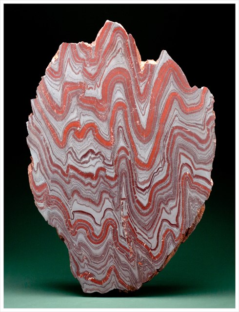
Due to construction of an ADA compliant ramp the specimen has been enclosed in a plywood box and is not visible at this time. Here, on the west platform, you will see a large red and gray rock striped rock, known as Banded Iron Stone. There are large deposits of banded iron in northern Minnesota (the origin of the example at GZ) as well as on all other continents, know collectively as BIFs.
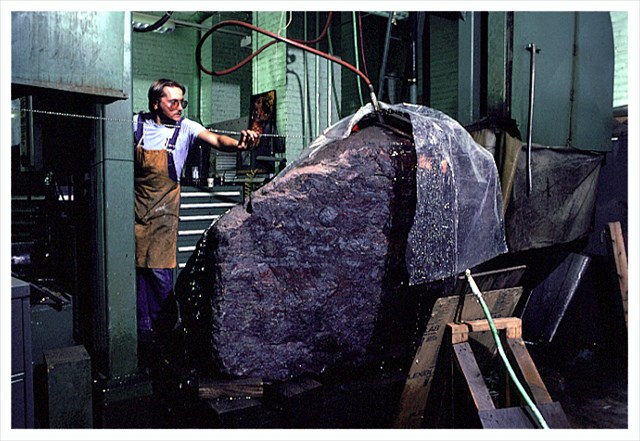
This boulder was cut using silicon carbide abrasive slurry on a wire saw, here at the museum. The surface was then polished using a pneumatic rotary grinding and polishing tool. In all it took a month’s time to cut and polish this stone. In the image the Tim Rose, of the Department of Mineral Sciences, is shown positioning the wire to start the cut.
There are three major rock types – igneous (rocks cooled from a melt), sedimentary (eroded rock particles were transported by wind or water and deposited, or formed by biologic activity or precipitated from water by chemical processes), and Metamorphic (rocks that have been altered by heat and/or pressure to produce a change in their mineralogical composition among other features). This rock is one of a subset of sedimentary rocks often referred to as biochemical sedimentary rocks implying that living organisms played a significant role in their formation. Other examples are coal (plants incorporating carbon from the atmosphere into their vegetative bodies) and limestones (marine organisms using the calcium carbonate in seawater to construct their shells and skeletal frameworks).
Each layer in the banded iron stone was originally deposited horizontally on the ocean floor. The folding of the layers is thought to be the result of soft sediment deformation due to gravity sliding down a very gentle slope. The red bands are layers of SiO2 in the form of chert. There is a small amount of iron oxide (rust) that produce the red color. The source of the silica from which the chert was formed may have been wind blow in the ocean. The red color is imparted by the inclusion of minute amounts of red iron oxide. The gray layers are hematite and magnetite, two crystalline forms of iron oxide.
The red and gray layers of sediment were deposited about 2,250,000,000 (2.25 billion) years ago. At that time the earth and its atmosphere were very different than that of today. Then, there was very little, if any, free oxygen in the atmosphere and the oceans were acidic. Iron is soluble in neutral and more so in acidic waters (low pH). Thus more iron was in solution in the acidic oceans than is possible under current conditions. Between 2.5 and 1.8 billion years ago, photosynthetic cyanobacteria (blue green algae) living in the oceans began producing free oxygen as a by-product of photosynthesis. The dissolved iron and free oxygen combined easily to produce iron oxide, in this case, hematite (Fe2O3) and/or magnetite (Fe3O4) both of which are much less soluble in water. Thus, as solid iron oxide was formed it sank to the ocean floor. Without the photosynthetic activity of the blue-green algae there would not have been the oxygen necessary to form the insoluble iron oxides.
There is rhythmicity in the deposition of the red and gray layers. There are several possible explanations for the rhythmicity. It may be the seasonal mixing of the water column due to temperature variations of the surface waters, or it may be that the blue-green algae produced so much excess oxygen that it poisoned periodically dyeing out until the free oxygen levels were reduced through iron oxide formation. During this interval the silica would be blown into the water and form a red band. Then the blue-green algae would repopulate the water and begin to produce free oxygen which combined with the dissolved iron to form another layer of gray hematite and magnetite. This cyclicity persisted to form a BIF.
To log this Earthcache you must answer the following questions and e-mail the answers to the address in our profile.
By 3,800 million years ago the Earth had cooled enough for the crust to have solidified into rock and there were oceans, but the atmosphere was quite different from today's.
1) Do you think the "Water Cycle" was working then? Briefly - Why
2) Do you think that the ocean that the BIFs formed in covered much of the Earth? Why?
3) BIFs could not form today due to the high levels of free oxygen present in the atmosphere. What other condition has changed such that BIFs could not form today?
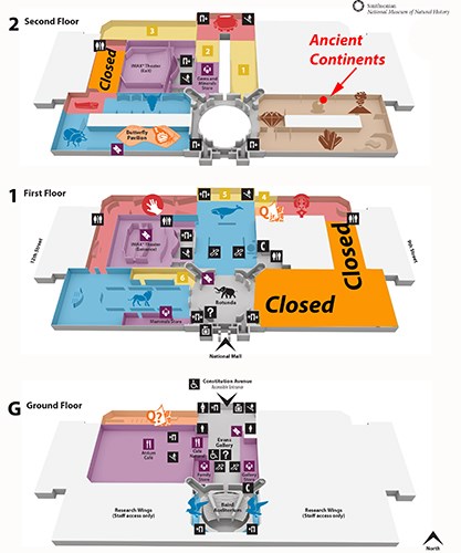
Now go to the exhibit hall immediately to the left of the Hope Diamond on the second floor. Near the globe in the middle of the hall you will find several display cases about "Building a Continent". Here you will see specimen of banded iron and other rocks that tell parts of the early history of the Earth.
4) There is mineralogical evidence for the existence of water on earth much earlier than the evidence of bodies of water contained in this exhibit. What rock provides the evidence for bodies of water on earth? This specimen was a gift of a company with a mineral in its name. What is the name of this company? Extra credit for the name of the mineral.
5) The label for the BIF specimen here states the oldest age for BIFs is 2.1 - 1.8 billion years. How much older is the oldest known Earth rock in the exhibit?
If you are doing all the caches you will need to obtain the code word for this cache. See the hint for code word instrucitons.
NMNH GEOTOUR GEOCOIN!
Critical requirements and rules for the award of the geocoin are here NMNH GeoTour Passport
1) The Original 9 caches of the NMNH GeoTour must be completed.
2) Two (2) photographs are required. Posted with your found log. (This is not an ALR as you may log a find on these two caches without posting a picture. It is a requirement to be awarded a geocoin. In other words – no photos no coin but your found log will stand).
a. Photo of an adult at GC3RRWA "CINMAR" with the log book clearly next to the face. Do not expose the code word in the photo.
b. Photo of an adult at GC3T24J “Leave it to Beaver” with the log book clearly next to the face. Do not expose the code word in the photo.
3) A completed Passport with the required code words sent to the address listed on the Passport.
4) One (1) coin per household or mailing address. If there are multiple geocachers in a household who have completed the tour, only one (1) coin will be awarded to that address.
5) The passports that have been received prior to January 1, 2016 will be awarded one coin without having to meet item 1 above, and these rules were not in effect for the NMNH GeoTour at that time.
6) January 1 will be the date of publication of these requirements to earn the geocoin.


Additional Hints
(Decrypt)
Pbqr jbeq pbafvfgf bs gjb jbeqf: Frpbaq Sybbe "Gur Napvrag Pbagvaragf" fvta unf guerr cnentencuf [paragraph, line, word, letter] - - [2,1,8,5] [2,4,1,6][1,1,5,9][2,2,7,2][3,2,1,8][3,2,4,7][1,1,7,1][2,1,2,2][1,1,2,2] "Jurer Cyngrf pbzr gbtrgure" fvta unf guerr cnentencuf [paragraph, line, word, letter] - - [2,4,3,7][2,2,6,1][2,1,6,2][1,2,5,6]