CINMAR South Mountain: Smithsonian NMNH GeoTour Mystery Cache
CINMAR South Mountain: Smithsonian NMNH GeoTour
-
Difficulty:
-

-
Terrain:
-

Size:  (small)
Related Web Page
Please note Use of geocaching.com services is subject to the terms and conditions
in our disclaimer.
This cache was originally part of the, now archived, National Museum of Natural History GeoTour. The cache features Pennsylvania's Michaux State Forest.
The posted coordinates will take you to the middle of Carbaugh Reservoir. Parking is available within 200 feet of the cache. All the roads are well maintained and unless muddy, snowy or ice covered the cache is accessible to any wheeled vehicle. The best access is from the west.
Apprently there is a bridge being rebuilt so the west approach is temporarily not open. Try from the East: Depart Rt 30 at Newman Rd (N39 53.853 W077 25.607) and drive south approximately 2.4 miles. Turn right on District Rd and drive to the final coords
. The cache is located in Michaux State Forest which is named after the French botanist Francois Andre Michaux, who, in 1802 traveled across Pennsylvania. This cache is about a stone knife blade, where it was found and where it came from.
Michaux State Forest has a protected rattlesnake population that is being studied by biologists. Snakes with tracking devices have been found to make 2 – 3 mile loops from their dens through the year. There is no known den near the cache’s final location but that does not mean that a wandering buzzmuggle (aka Rattlesnake) might not be around – so be wary. If you should encounter any snake DO NOT KILL IT!!! It has no interest in biting you any more than you want to bite it. If you leave it alone it will do you no harm. They are protected!! Respect and appreciate nature – you are visiting their home not the other way around.
The scientific method includes always questioning what is known. For many years it has been thought that the earliest people arrived from Asia via a land bridge between Siberia and Alaska. Around 14,000 years ago, so much water was locked up in continental glaciers that humans could travel between the continents at the current position of the shallow (50 meter (160 feet) deep), narrow (85 kilometers (53 mile) wide) Bering Strait. But a few archaeological finds over the past 30 years challenge the widely accepted hypothesis that this was the earliest route into North America.
Dennis Stanford of the Smithsonian’s National Museum of Natural History, Department of Anthropology’s along with colleagues, has proposed another hypothesis: one in which humans arrived in North America much earlier than 14,000 years ago, traveling across the North Atlantic from Europe.
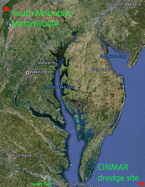
In 1974 the vessel CINMAR, while dredging for deep-sea scallops in 75 meters (250 feet) of water near North 37° 2.500’ West 074°50.000’ on the edge of the continental shelf, hauled up mastodon bones and a knife blade.
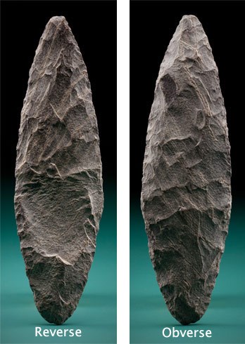
The mastodon bones were determined by radiocarbon dating to be about 23,000 years old. Mineralogical analysis of the knife blade found that it matched the composition of the National Museum’s Mineral Sciences specimen #60892. This sample had been collected over 120 years earlier and described in 1896 by Bascom in his study of “The Ancient Volcanic rocks of South Mountain, Pennsylvania. This mineralogical match and archaeological evidence on South Mountain shows that the CINMAR blade was fabricated from metarhyolite quarried on South Mountain in southern Pennsylvania. The fact that both the 23,000 year old mastodon bones and the knife blade were in the same dredge haul indicates an association of the two. What is the significance of this association? Was a human hunting or butchering a mastodon; at the dredge location when sea level was lower and the dredge site was above sea level? Were they brought together by water currents at a more recent time? Was the blade dropped over the side of a boat at a much later time (less than 13,000 years ago) when sea level had risen and the Atlantic Ocean covered the site? As with many things in the natural sciences it comes down to probability and choosing the most reasonable answer that fits the data.
What is the history of this blade, where did it come from, and how did it end up 250 feet below the surface of the Atlantic Ocean on the outer continental shelf?
The CINMAR blade is made of stone from the Catocin Formation, of a type known as metarhyolite. A rhyolite is an extrusive volcanic rock with a high content of silica. This Catoctin metarhyolite erupted as rhyolite during the rifting of North America and formation of the Iapetus Ocean that took place about 565 million years ago. Between 320 – 290 million years ago, the Iapetus Ocean closed as the continents reassembled to form Pangea, this tectonic activity metamorphosed the rhyolite as the present day Appalachian Mountains werefolded and thrust upward. Subsequent erosion reduced the Appalachians and exposed the resulting metarhyolite of the Catoctin Formation.
Prehistoric North American stone-based cultures found this metarhyolite suitable for fabricating tools. An extensive, long-lasting industry of mining and fabrication using metarhyolite is known to have existed from about 13,000 to 500 years ago. Recent discoveries, including the dredged CINMAR blade, suggest that the mining and fabrication of tools from this metarhyolite may have taken place over a much greater time than previously thought.
Changing climate: The Pleistocene (2.6 million – 12,000 years) is known for the waxing and waning of continental glaciers. When the glaciers covered large areas of the continents, sea level was low. When they reduced in size, sea level would rise. Between 26,500 and 19,000 years ago the continental glaciers increased in size for the last time, during what is known as the Last Glacial Maximum (LGM).
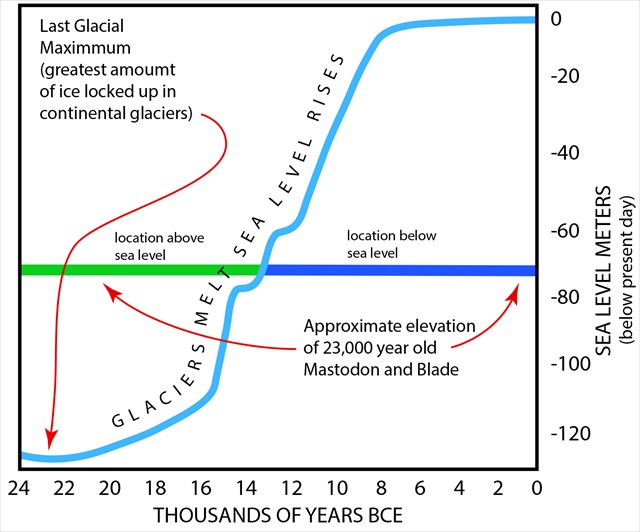
At that time, sea level was 125 meters (410 feet) lower than today. Low sea level 23,000 years ago would have exposed a great deal of the continental shelf, including the location from which the scallop boat CINMAR dredged up the mastodon and knife blade. Thus the mastodon and the person carrying the knife blade would have been walking on ground and eating plants that were growing in a place that is now roughly 100 kilometers (60 miles) off shore and under 75 meters (250 feet) of water.
Archaeologists have long been able to identify stone tools as distinctly associated with certain cultures, places and time. This is because different fabrication techniques resulted in recognizable features on the implements. A well know example of this is the Folsom blade with its distinctive longitudinal flute on both faces.
The CINMAR blade compares well with fabrication types used by the Solutrean culture, which existed in parts of Spain and France more than 20,000 years ago.
If one accepts the association of the CINMAR blade with the 23,000 year old mastodon as proof that humans were, at that time, in the Chesapeake Bay region (the bay would have been a valley through which the Susquehanna River flowed) the question follows – to whom were they related and how did they get there? There are two reasonable possibilities. First – two populations of people living on opposite sides of the Atlantic Ocean almost simultaneously came up with the same distinctive type of tool fabrication; or second, people who were utilizing this type of fabrication techniques dispersed from Spain and France to the Chesapeake Bay region. Dennis Stanford is a proponent of the later hypothesis.
The hypothesis that the Solutrean culture spread into North America can be summarized in the following way: During the LGM, significant areas of the continental shelf, currently under water, were exposed and habitable, and ice sheets covered much of the North Atlantic. People with Inuit-like technology such as seal skin kayaks crossed the North Atlantic as they hunted along the ice edge and settled in the Chesapeake Bay region and other areas in North America.
Many unanswered questions remain about when and how humans first populated North America. It is only with continued field research and study that the answers will be understood and fully accepted.
To claim this cache you must determine the final coordinates using information on this cache page.
N 39° AB.CDE W 077° VW.XYZ
A = Digit sum of the water depth, in meters, of the present day Bering Straights.
B = Last digit in the Mineral Sciences specimen number of the metarhyolite from South Mountain.
C = Digit sum of the radiometric age of the Mastodon bones.
D = In 18D6 Bascom published his study of the volcanic rocks of South Mountain.
E = A long period of mining and fabrication lasted from about 1Q,000 to 500 years ago. E=Q-1
V = The ship CINMAR was dredging for mollusks near North 37° V.500’.
W = During the LGM the sea level was [check sum digit] meters lower than today.
X = The dredge site today would be X00 kilometers off shore.
Y = The Solutreans lived in France and Spain Y0,000 ago.
Z = Between 320 – 2Z0 million years ago, the Iapetus Ocean closed.
Check sum digit for AB.CDE = 5 Check sum digit for VW.XYZ = 4
Citations:
R.G. Fairbanks 1989. A 17 000-year glacio-eustatic sea level record: influence of glacial melting rates on the younger Dyras event and deep-ocean circulation. Nature, 342 (1989), pp. 637–642.
Stanford, Dennis J. and Bruce A. Bradley. 2012. Across Atlantic Ice: The Origins of America’s Clovis Culture. University of California Press, Berkeley xv - 319pp.
http://radiocarbon.ldeo.columbia.edu/images/Sea.level/sea.level.plot_web.JPG
Ordovician 572 ma Catoctin Volcanic Province.
J.N. Aleinikoff, R.E. Zartman, M. Walter, D.W. Rankin, P.T. Lyttle, W.C. Burton, U–Pb ages of metarhyolites of the Catoctin and Mount Rogers formations, central and southern Appalachians: Evidence for two pulses of Iapetan rifting, Am. J. Sci. 295 (1995) 428–454.

Additional Hints
(Decrypt)
Guvf pnpurf vf abg zrnag gb or n punyyratvat svaq ohg na rqhpngvbany rkcrevrapr. Cybg gur pbeqf ba tbbtyr rnegu be fbzr bgure znc naq lbh fubhyq unir yvggyr ceboyrz jvgu gur TCF obhapr.