A blue hole is a depression or sinkhole that is filled with water.
There are famous ones at are underwater in oceans and more common
ones located inland are associated with karst (cave) regions. The
name is derived from the color of the water contained in them. They
are formed by the same general process, the erosion of underlying
bedrock that results in the collapse or subsidence of the
surface.
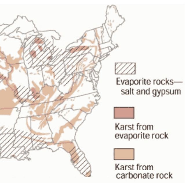
Sink Holes
Sink holes are common in limestone and other carbonate rock, and
salt beds. In the Midwest sink holes are common in karst regions
where there is much limestone bedrock present. South of this
location, in Kentucky, much of the state is karst. In Hamilton
County there are few karst areas. A Ohio Geological Survey karst
map identifies 3 general areas of known karst in Hamilton county.
These are located at the western end of Winton Lake, North of
Taylor creek, and here in Mount Airy Forest. In Mount Airy Forest
the different levels of bedrock contain only 25 to 50% limestone,
so it is a little unusual to have sinkholes here. But there are and
they tend to be small, less than 25 meters in diameter and 3 meters
deep. Virtually, none of them hold water other than the one before
you. Below is a map of
karst regions in the eastern United States.
As mentioned above sink holes are formed by the erosion of the
limestone bedrock.
The typical mechanism
for this erosion is slightly acidic rain water. A very weak
carbonic acid is created when rain passes through the air and picks
up carbon dioxide (CO2) which dissolves in the rain
water. As the rain
passes through the soil it picks up additional
CO2.
The water can
then work its way through cracks in the rock. This acidic water can then
dissolve the calcium carbonate (CaCO3) in the limestone,
leaving voids. As the
cracks and voids grow, the faster flowing weak acidic solution can
accelerate the erosion process. Over time the void becomes large
enough that any landform above it might collapse or subside forming
the sinkhole. The
chemical process is shown below.

Sink holes are often in the news when they are formed by unnatural
processes (broken water main washing away soil under a roadbed) and
interfere with human activities.
Natural sinkhole processes are classified as collapse, subsidence,
solution, and alluvial. Briefly, this is how the
mechanisms vary.
Solution sinkholes - these form in a
similar way as subsidence sinkholes except that there is only
exposed rock and no overlying sediments. As water infiltrates
fractures in the soluble rock, it begins widening the crack. This
may form a collection site for groundwater providing that the water
cannot leak through the layers of rock below, or haven?t yet eroded
through to another fracture becoming subsurface groundwater. The
diagram below shows a solution sinkhole, note the thin or
non-existent sediment layer on top
Subsidence
sinkholes occur in karst areas covered by soils or other
unconsolidated materials. They appear to occur very quickly , due
to the fast collapse of the overlying materials. The reasoning
behind this is that most of the solution process takes place under
the surface. Upon formation, a cylindrical hole is created. The
hole is then eroded over a period of time into more of a bowl
shape. These sinkholes are eroded and widened very easily sue to
the presence of soils and unconsolidated materials located on the
rims of the hole. Subsidence sinkholes are also prone to become
ponds of varied sizes.
Collapse
sinkholes form either from sudden mass movements of karst bedrock
due to sudden drops in the water table or when the roof of an
underground cavern or cave collapses, or both. Unlike solution
sinkholes, collapse sinkholes can be angular in shape with vertical
walls. Over time, abrasion will erode the walls and create a round
or oval-shaped sinkhole. One common reason for a sudden drop in the
water table is excessive groundwater pumping. Over time, collapse
sinkholes often fill with water.
Alluvial
stream sinkholes are created by streams sinking through deposits of
alluvium on the surface of the landscape into the underlying
soluble karst bedrock. The same natural processes that lead to the
formation of subsidence sinkholes can also lead to alluvial stream
sinkhole formation. These sinkholes are often prone to filling of
water
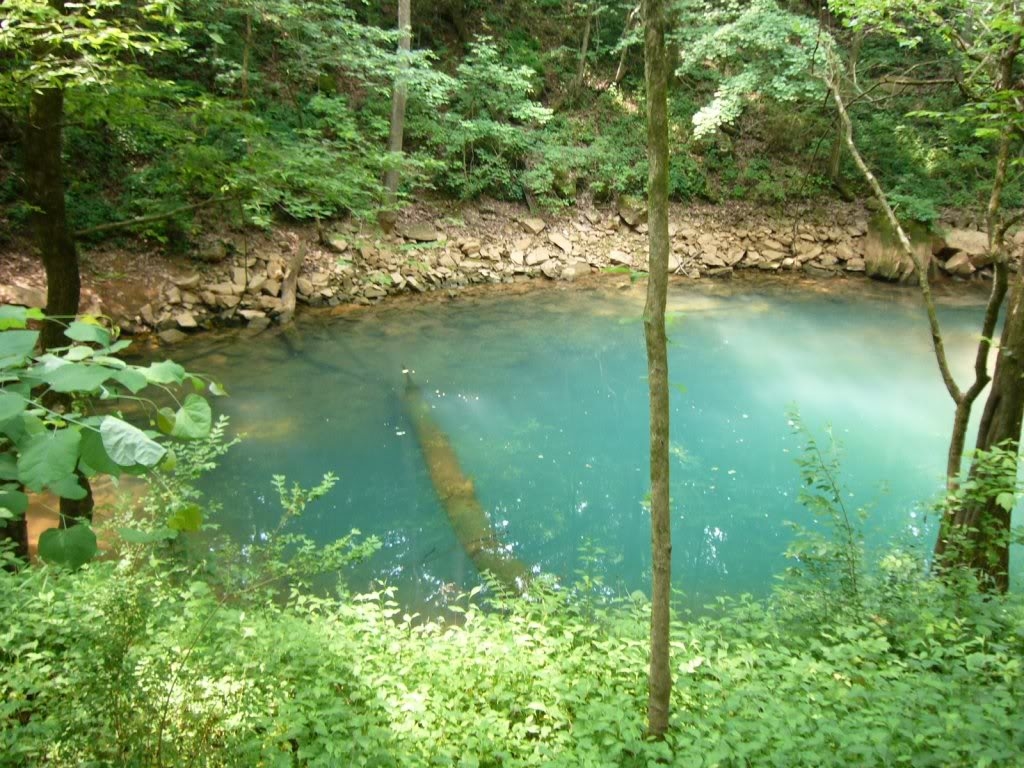
Blue Holes
As stated above blue holes are sink holes that contain
water. They are
obviously less common than ?dry? sinkholes. To be filled with water the
sinkhole needs to be below the water table level or constantly fed
with water. Some of
the more famous ones lie under the ocean. The one shown below is in Belize
and a favorite for divers.

At times the blue hole will be under a river like at http://coord.info/GC20CPJ.
At times the water in a blue hole will come from and underground
stream. That is the
case for the blue holes at Cedar Sinkhole near Mammoth Cave
http://coord.info/GC2QF82

or at Lost River Cave
http://coord.info/GC2E3FB.
These are sometimes called karst windows. These are sinkholes that
developed over existing underground streams/caves. At times streams will disappear
into or emerge from a blue hole. Blue holes in general are somewhat
circular, steep-walled depressions. They are named for the blue hue
of the water. The blue holes appear blue from the sun reflecting
off microscopic particles of limestone in the water.
Logging Requirements ? Please email the
answers to these questions:
1)
Estimate the width, length and depth of the
blue hole.
2)
What is the water supply for this
hole?
3)
What type of sinkhole is this:
collapse, subsidence, solution, or alluvial and why?
4)
What helps give the water in this blue hole its color?
5)
Optional: a photo of yourself at the site.