Jednoduchá a krátká multina, která vás provede po nově vzniklé naučné stezce Lesní svět, od Myšlínského potoka na vrch Vlčí Halíř u osady stejného názvu. Vzhledem ke své délce ideální i pro děti, pro něž byla primárně stezka navržena a stejně tak i tato keš.
Kdybyste tudy šli před několika lety, těžko byste prostředí rozpoznali. Most, u kterého trasa multiny začíná, byl dříve jen drobným můstkem, pod nímž se pouštěly lodičky a stavěly přehrádky na potoce. Stezka vzhůru byla jen lesní pěšinou. Některé věci však přece jen zůstaly - je tu klid a nahoře vás v letních měsících čeká odměna ve formě ostružin. A najdete-li i finálku, což by problém být neměl, vyskytne se vám poměrně zajímavý výhled na další část Mnichovic.
Celá trasa (až na kousek k finálce) lze absolvovat na kole či s dítětem v kočárku (obě možnosti mnohokrát ozkoušeny). Takže již žádné otálení a hurá do kopce!
Úvodní souřadnice vás zavedou k první tabuli naučné stezky. Zde je rovnou i první stage.
Stage 1 Strom jako dům - N 49° 55,871 E 14° 43,470
Zde zjistěte v jaké řadě (shora) je ukrytá veverka obecná? Číslo řady = A
Stage 2 Tabulky poznání - Rostliny - N 49° 55,855 E 14° 43,550
Vaším dalším úkolem bude nalézt orsej jarní - v kterém je sloupci (zleva)? Číslo sloupce = B
Stage 3 Dřeviny - otočné kolo - N 49° 55,858 E 14° 43,596
Po přiřazení všech dvojic sečtěte jehličnaté stromy na tabuli a odečtěte je od těch listnatých. Výsledkem budiž C
Stage 4 Srnec obecný - myslivecká mluva - N 49° 55,813 E 14° 43,724
Zvládnete přiřadit všechny pojmy? Pokud ano, nebude problém spočítat všechna zvířata na tabuli. Součet (i těch na první pohled skrytých) je D
Stage 5 Potravní labyrint - N 49° 55,812 E 14° 43,807
Přitvrdíme. Jaké je druhové jméno zobrazeného měkkýše na obrázku? A z kolika je písmen? Počet písmen druhového jména = E
Stage 6 Mravenci a mraveniště - N 49° 55,790 E 14° 43,898
Pořádně si prohlédněte tabuli a spočítejte, kolik je zde nadpisů? Součet nadpisů = F
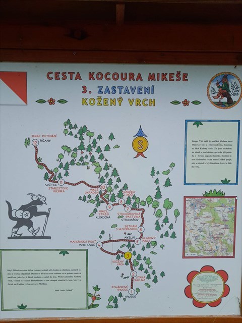 Cestou na poslední stage projdete kolem stage jiné naučné stezky s názvem "Cesta kocoura Mikeše - 3. zastavení - Kožený vrch". Sice si informace určitě přečtěte, neboť vám poví mnoho zajímavého o místech kam míří tato multicache, ale poslední indicii odtud nezískáte, ta je až na další tabuli o kus dál.
Stage 7 Rozklad odpadků - N 49° 55,781 E 14° 43,944
Zde provedeme poslední početní úlohu - kdybychom obalili nedopalek žvýkačkou, kolik let se bude rozkládat? Roky rozkladu = G
Nyní je čas občerstvit se, jste na konci naučné stezky. V létě si nabídněte místní ostružiny, jinak se po krátkém výpočtu můžete směle vydat na finální souřadnice, nebojte už to bude jen kousek a jen mírně do kopce.
N49° 55.(C+D)(A)(A)
E 14° 43.(B+F)(G-E)(B+E)
Věřím, že vás stejně jako mě pohled od kešky potěší, georobotci třeba najdou ve schránce něco k výměně (při základu jsme tam toho dali, co se vešlo) a zpátky to už máte jen z kopce ;-)
Jo a i tady je bonusové číslo, tak poznamenejte, kdo ví...
An easy and short multi, which leads you through a new built nature trail A forest world, from the Myšlín's stream to the hill Wolf's Heller next the village of the same name. In fact to its lenght is this path ideal for children, for who it was primarily invented, as like as this cache.
If you went through this area before some years, you have hardly recognized the environment. The bridge, where the trail of the multi starts, was formerly only a little bridge, under that children let their little boats float and constructed little dams on a the stream. The path upwards was only a forest foothpath. But some things stayed yet - there is a calm and there is a reward upwards for you in a form of blackberries. And if you find a final cache, which should not be a problem, an interesting view on a next part of Mnichovice will occur.
The whole track (excluding a little part to a final cache) is accessible for bikes and prams with children (both possibilities many times tested). So no more waiting and hurray uphill!
The given coordinates leads you to a first panel of a nature trail. Here is directly the first stage too.
Stage 1 A tree as a house - N 49° 55,871 E 14° 43,470
Find here in which line (from above) is hidden a squirrel common? The number of the line = A
Stage 2 Tables of a cognition - Plants - N 49° 55,855 E 14° 43,550
Your next task is to find an "orsej jarní" - in which column (from left) it is? The number of the column = B
Stage 3 Woody plants - a turning wheel - N 49° 55,858 E 14° 43,596
After combinating all pairs, count up coniferous trees on the panel and subtract them from broad-leaved trees. The result is C
Stage 4 A roe deer common - a hunter's slang - N 49° 55,813 E 14° 43,724
Will you be able handle with all terms? If yes, it will not be problem to count all the animals on the panel. The count (the hidden ones too) is D
Stage 5 A food labyrint - N 49° 55,812 E 14° 43,807
We get tougher. What is a species name of a displayed mollusc in the picture? And how many letters this name has? The count of letters of a species name = E
Stage 6 Ants and anthill - N 49° 55,790 E 14° 43,898
Look properly on the panel and get the count od headings there. The count of headings = F
When going to the last stage, you will pass a stage of an another natural trail called "The yourney of a cat Mikeš - 3rd stop - Leather hill". Read informations, they will tell you many interesting details of places where this multicache leads, but you could not get there the last clue, it is only on the next panel near this place.
Stage 7 A decomposition of rubbish - N 49° 55,781 E 14° 43,944
We make here the last counting task - if we wrap cigarette butt with a gum, how many years it will decomposite? Years of the decomposition = G
Now there is a time to have a snack, you are in the end of the natural trail. When summer, you can offer yourself local blackberries, otherwise after a short count you can boldly set out to final coordinates, do not worry, it will be only a short hike uphill.
N49° 55.(C+D)(A)(A)
E 14° 43.(B+F)(G-E)(B+E)
I believe, that the view from the cache will make you happy like me, georobots will maybe find something for exchange in the container (when hide we fill up richly the container) and the way back is only downhill ;-)
Yeah and there is a bonus number too, so note it down, who knows...
Líbí se vám tato krabička? Zkuste i mé další!
V oblasti:
V Praze:
Škůderské kopce:
Série Škůderských křížků:
Velká Úpa:
Do you like this container? Try my more caches!
In area:
In Prague:
Škůdra's hills:
Škůdra's cross' series: