De Staringgroeve EarthCache
-
Difficulty:
-

-
Terrain:
-

Size:  (other)
Please note Use of geocaching.com services is subject to the terms and conditions
in our disclaimer.
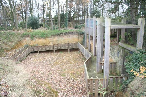
Nederlands: De Staringgroeve is een uitgegraven oude put en opengesteld voor het publiek en er omheen werd een parkje aangelegd. English: The Staringgroeve is an old pit which is excavated and open for the public. This quarry is located in a small park.
De Staringgroeve
Nederlands:
In de 19e eeuw nam de belangstelling voor techniek en wetenschap sterk toe; ook de geologie kwam tot bloei. De Losserse Es, een lichte glooiing in het landschap, leek een veelbelovende plek voor het vinden van delfstoffen: op de es lagen hier en daar brokken zandsteen. Tien kilometer verderop “verheffen zich plotseling de hoge Molenberg van Gildehaus en daarachter de Bentheimse rots, schreef W.C.H.Staring, een van de grondleggers van de geologie. Naar hem is ook de groeve genoemd die als proefput diende om de Losserse Es te onderzoeken. Hij toonde de aanwezigheid van zandsteen op 10 meter diepte aan. Exploitatie bleek niet lonend, omdat het materiaal te lemig en kalkhoudend was om als bouwsteen of meststof (kalk) te gebruiken. Bovendien was deze “Gildehauser” kalksteen poreus en bevatte het veel “verontreinigingen” van fossiele resten zoals schelpen, slakken en een enkele ammoniet.De zandsteen van Losser is ontstaan in de Krijtperiode 130 miljoen jaar geleden, evenals de zandsteen in Gildehaus. De zandsteen in Bentheim is 140 miljoen jaar oud, veel harder en daardoor zeer geschikt als bouwmateriaal. In de Middeleeuwse bouwkunst werd zandsteen vooral gebruikt voor kerken. De Romaanse delen van de St.Plechelmusbasiliek in Oldenzaal, (ca 1200), vormen hiervan een goed voorbeeld.
Door toenemende welvaart kwam het gebruik van zandsteen vanaf de 17de ook binnen het bereik van burgers: particuliere huizen en ook stadhuizen werden deels voorzien van zandsteen ( voormalig stadhuis van Almelo en Neuenhausuit de 17de resp. 18de eeuw, zandstenen voorgevel van het stadhuis in Ootmarsum).Buitenwanden van vakwerkboerderijen stonden tot ca.1700 op lange eikenhouten balken op de grond. Deze werden steeds meer vervangen door rijen rechthoekige blokken zandsteen. Ook werd in grote boerderijen veelal de leemvloer vervangen door vloerplaten van zandsteen. Het vee kreeg zandstenen voederbakken. De Staringgroeve is in 1968 tot stand gekomen, mede door W.F.Anderson, die met een aktetas vol geologische vondsten – gekregen van de Losserse bevolking – naar de burgemeester van Losser ging. Hij wist het gemeentebestuur te overtuigen dat de oude put aan de Hogeweg een unieke geologische groeve was. Plannen om de Losserse Es voor woningbouw in te richten, zijn toen aangepast.
The Staringgroeve
English:
In the 19th century there was a strong interest in technology and science and Geology. The Losserse Es, a light slope, looked like a promising place to find minerals, here and there lay some pieces of sandstone.Ten kilometres in the distance you will suddenly see the high Mill Mountain of Gildehaus and behind it the Bentheimse rock, written down by W.C.H.Staring, one of the founders of Geology in Holland. This quarry, use as a test pit to excavate the Losserse Es, is named after him. He showed the presence of sandstone at a depth of 10 meters. Exploiting it was not workable, because the material was too calcareous and muddy, to use as building material or fertilizer. Furthermore this “Gildehauser” limestone was porous and contained fossilized “pollution” like shells, snails and some ammonite. This Losser and Gildehaus sandstone originate back 130 million years ago. The sandstone in Bentheim dates back 140 million years ago and is much harder and suitable as building material. In the mediaeval architecture sandstone was used to build churches. The Roman parts of the St.Plechelmusbasiliek in the town of Oldenzaal (ca 1200) are a good example. Because of growing prosperity, civilians also used more and more sandstone in there houses and barns. They also used sandstone in parts of city halls (formerly city hall from the town of Almelo en Neuenhaus in the 17th and 18th century, and a sandstone front of the Ootmarsum city hall). Long time they used long oak blocks beneath the supporting wall’s of farmhouses until 1700, after that they use more and more rectangle sandstone blocks. In large farms they replaced the loam floor with plates of sandstone. Also the cattle got sandstone cratches. The Staringgroeve was founded in 1968 by W.F.Anderson who went with a bag full of geological finds to the mayor of the town of Losser. He convinced the city council that the old pit in the Hogeweg was a unique geological quarry. Plans to build on this quarry were adjusted.
To log this Earth cache:
Nederlands:
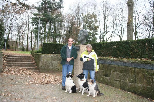
Foto: Maak op het coördinaat dat bovenaan deze pagina staat een foto van jezelf met je GPS en het monument van Dr. W.C.H.Staring en voeg deze bij je log.
Opdracht: Als voorwaarde om deze earthcache te mogen loggen moet je een email sturen aan de makers van deze cache met het antwoord op de volgende informatie; loop naar N52.15.376 E007 00.432. Hier vind je een aantal informatieborden over de fossielen die hier zijn aangetroffen. Op bord nummer 2 staat bij figuur 1 een Latijnse naam van een van deze vondsten en een jaartal, bij de ingang van het toegangshek staat de volledige datum dat deze groeve werd geopend. Stuur deze antwoorden per email naar de makers. “Indien de email niet goedgekeurd is, wordt de log verwijderd”.
De borden zijn niet meer op hun plek, dus deze vraag mag tijdelijk overgeslagen worden, het bord bij de ingang hangt er nog wel dus dit antwoord moet wel gemaild worden.
English:
Picture: Go to the coordinates on top of this page and take a photo of yourself with your GPS and the monument of Dr.W.C.H.Staring and add this picture to your log.
Assignment: For logging this cache you are required to send an e-mail to the makers of this cache which contains the following: Go to N52.15.376 E007 00.432. Here you will find a few information signs. On board number 2 figure 1 you see a Latin name from one of these fossils and a date (year), at the entrance-gate is a small plate in the wall, in this plate you will see the complete date this quarry is opened. Send these answers via e-mail. If an e-mail is found to be incorrect the log will be deleted.
The info sign is not at its place anymore, so temporarly skip this question, the sign next to the entrance is still in its place so this answer you have to mail.
Additional Hints
(No hints available.)