
Assateague Island stretches for 37 miles along the Atlantic coasts of Maryland and Virginia and is part of a vast chain of barrier islands extending from Maine to Texas. Changing sea level and migration of offshore sediments play vital roles in forming and maintaining these important coastal features. Barrier islands can form when offshore sand deposits accumulate sufficiently to break the water surface or when sea level rise causes inland dunes to become separated from the mainland. Others form when “spits” deposited across the mouth of a bay eventually break from the mainland.
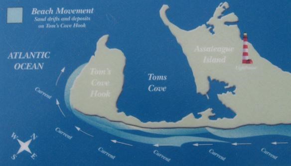
Barrier islands like Assateague are highly dynamic places, as currents and storms work to continuously reshape the land form. Though changing course periodically throughout the year, long shore currents continuously transport sand south along the coast. On a seasonal basis, harsh winter weather pulls sand from dunes and upper beaches, depositing it into offshore sand bars and reducing beach width. This process is reversed during milder summer weather, as gentler wave action acts to restore the shoreline.
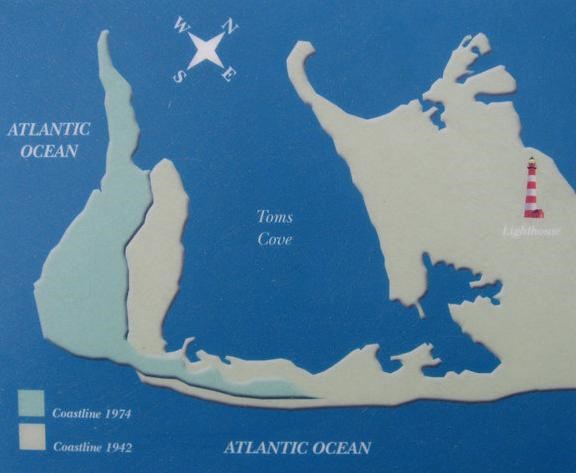
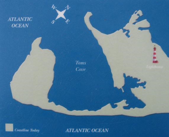
Assateague is also moving westward as a result of sea-level rise and the force of the surf through a process called “island rollover.” During severe storm events, sand is eroded from the ocean beaches and carried across the island by flood waters and re-deposited in marshes along the western shore, steadily narrowing the bay that separates the island from the mainland. These events can break through dunes, spilling sand in fanlike deposits or even carving inlets, such as the one that has separated Assateague and Ocean City since 1933. Long shore currents will eventually deposit sediments and close these gaps unless, like the Ocean City inlet, it is maintained with jetties and dredging.
The Atlantic Ocean lies along the eastern side of Assateague Island, with the park's boundary extending a half mile into its waters. The ocean acts to constantly sculpt the shore by transporting sand to and from offshore areas and along the coastline itself, and by occasionally washing sediments over the island and depositing them in the bay to the west.
When the Assateague Lighthouse was built, it was close to the sea, on the south end of the island. Since then, the island has moved around it. The lighthouse itself has remained in its original location.
The changes made by ocean currents happen too gradually to see, but major storms cause sudden changes that are hard to miss. In one giant whoosh, a storm can change the shape of Assateague Island by pushing sand from the beach onto the island's interior. The storm of 1933, for example, actually created the Ocean City inlet!
Have you ever swum into the ocean and back to shore, only to find yourself further down the beach than before? The same ocean currents that carried you down the beach (called littoral currents) also move sand down the coast. Waves then sweep the sand into dunes. Sand grain by sand grain, the island changes shape and location.
Assateague is slowly but surely moving to the west and growing to the south. Like other barrier islands, Assateague is an ever-shifting pile of sand. Continually sculpted by water and wind its size, shape, and location have changed constantly throughout history. Assateague Island is forever on the move.

To log this earthcache:
Plan to arrive at the Toms Cove visitor's center during working hours. You will find the answers to the following questions by speaking with the Park Rangers. Send the answers to my email. Please DO NOT post answers in the cache log.
a. List the four natural occurances that are considered the prime movers of the island and specifically how each of them effect its shores?
b. How many feet westward does the island move each year?
c. What would it be like if you were standing at these coordinates in 1860?
d. What might happen to Toms Cove in the future?