
 Outcrops of burnt rock are found in a road cut and cliffs
on the east side of Grimes Canyon a little south of Fillmore.
There is a pullout with ample parking. The features can be
seen from the car, but the best examples do require walking
over uneven ground and weedwacking (terrain 2.5). Watch for
snakes, they love the rocky slopes.
Outcrops of burnt rock are found in a road cut and cliffs
on the east side of Grimes Canyon a little south of Fillmore.
There is a pullout with ample parking. The features can be
seen from the car, but the best examples do require walking
over uneven ground and weedwacking (terrain 2.5). Watch for
snakes, they love the rocky slopes.
The Monterey Formation is common near the coast of California.
In fact, similar rocks were deposited throughout the Pacific Rim
during the Miocene (17.5 to 6 million years ago). All of these
rocks share similar characteristics. They are
- Diatomaceous (made up of the shells of microscopic plankton
called diatoms)
- Phosphatic (containing phosphate)
- Dolomitic (containing dolomine); and
- Rich in organic matter (oil and gas).
This last characteristic, being rich in organic matter, makes
these rocks economically important because they often are
reservoirs for oil and gas. Most of the off-shore oil rigs along
the California coast are pulling oil from this formation. Across
the Pacific, Japan has similar rocks and oil reserves.
Whether from a lightning strike, spontaneous combustion, or some
other natural ignition source, the organic material in this area of
the Monterey Formation somehow began to burn and change the
surrounding rock in a process called combustion metamorphism.
Exhaust and steam moved upward from the fire altering rock far
above the subsurface fire. This movement of air sucked in oxygen
from the atmosphere inward through fractures in the rock.
References estimate that the temperature exceeded 1650 deg C,
enough to melt the rock.
 This changed the surrounding rock into ash, slag,
and glass-like material similar to obsidian that is sometimes
called fused shale. Thin ribbons of purple, red, yellow, and
black fused shale can be seen in the road cut and cliffs.
Additionally, during the recrystallization, the rock acquired
a magnetism that is stronger than the surrounding rocks.
This changed the surrounding rock into ash, slag,
and glass-like material similar to obsidian that is sometimes
called fused shale. Thin ribbons of purple, red, yellow, and
black fused shale can be seen in the road cut and cliffs.
Additionally, during the recrystallization, the rock acquired
a magnetism that is stronger than the surrounding rocks.
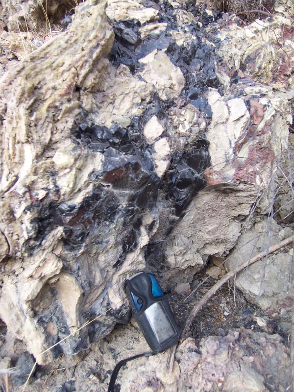
In the road cut the fused shale is in an approximate 3-inch
thick ribbon near the top of the cut (see the picture with
coordinates). In the cliffs, there are a series of layers with
fused shale, but you should find some large examples in the rocks
that lie at the base of the cliff at the coordinates. Look for the
purple and black glassy rocks.
Fused shale was used by the local Native American Villages to
create sharp tools and trade with other villages. Its use may have
begun 5000 years ago. Currently the material is mined and used as a
decorative stone.
Logging requirements:
Send me a note with :
- The text "GCZJMV Grimes Canyon Burnt Shale" on the first
line
- The number of people in your group.
- The powdery material at the base of the road cut and compare it
to ash you would find in a campfire;
- The glassy material and compare it to obsidian (or glass if you
haven’t seen obsidian)
- If you have a magnetic compass, see if it is affected by the
rocks in the area (post that in your log)
The above information was compiled from the
following sources:
- Geology and Mineral Resources Study of Southern
Ventura County, California, 1973, California Division of Mines and
Geology Preliminary Report 14
- Richard J. Behl California State University,
Long Beach, Monterey Formation,
http://seis.natsci.csulb.edu/rbehl/Mont.htm
- Santa Barbara and Ventura Basins, Tectonics,
Structure, Sedimentation, Oilfields Along an East-West Transect, A.
G. Sylvester and G.C. Brown Editors, Coast Geological Society Field
Guide No. 64
- Burnt Oil Shale Deposits of Ventura County, CA.
The Ventura Gem & Mineral Society, Inc. (VGMS) Rockhound
Rambling February 2004.
http://www.vgms.org/bt/vgms0402.htm