Mazama Ash - Edmonton EarthCache
-
Difficulty:
-

-
Terrain:
-
Size:  (not chosen)
Please note Use of geocaching.com services is subject to the terms and conditions
in our disclaimer.
Welcome to Edmonton's first EarthCache! Fine-grained flood plain
and overbank deposits of the North Saskatchewan found along
Edmonton’s river valley record one of the most spectacular and
catastrophic volcanic eruptions in North America since the end of
the last Ice Age.
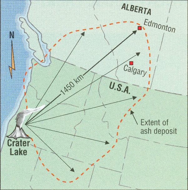
Mount Mazama of southern Oregon (about 1450 km southwest of
Edmonton) is part of a chain of volcanoes that formed around 400
000 years ago. For most of its history, Mazama’s eruptions were not
particularly violent. About 6800 years ago, Mount Mazama erupted
explosively, with a force 100 times greater than the Mount Saint
Helen’s eruption in 1980! The eruption drained the magma chamber
which fed the volcano and the mountain collapsed inwards, leaving a
deep crater called a caldera. The caldera, 9 kilometres wide and
1219 metres deep, is now occupied by Crater Lake, the second
deepest lake in North America. By the end of the eruption, almost
70 cubic kilometres of rock had been displaced.
Ash from this eruption was sent high into the stratosphere,
undoubtedly producing spectacular sunsets throughout the northern
hemisphere. The ash plume was carried by winds northeastwards,
blanketing almost 1.3 million square kilometres, including much of
southern Alberta.
Mazama Ash is often found in exposures along river valleys in
southern Alberta. Locally, the ash is preserved in North
Saskatchewan flood plain deposits which consist of alternating
layers of dark organic-rich beds and grey silt. The most prominent
and accessible exposures of the Mazama Ash can be seen just
upstream from the LRT Bridge on the south bank of the river. This
is one of the most northerly occurences of the Mazama Ash in
Alberta.

The ash horizon is a prominent centimetre-scale-thick silty layer
with a light-pinkish hue and gritty texture due to high volcanic
glass content. It occurs in a bed that is lighter in colour than
the beds above and below, and it looks like someone took a knife to
the exposure and cut a horizontal line through it. The layer
thickens and thins suggesting that it was quickly reworked and
redistributed by surface water after settling through the air.
Here, it is about one centimetre thick, but in southern parts of
the province it is thicker, simply because there areas were closer
to the eruption. Its age was determined by radiocarbon dating of
wood that was buried in the ash.
Like all volcanic ash deposits, the Mazama Ash has its own
distinctive mineral composition, which makes it useful for
correlating and dating deposits across large areas. It is a
particularly important tool for archeologists studying Alberta’s
past because they use it to date remains of older cultures. Any
artifact found below the ash is considered quite rare.
To log this EarthCache, take a picture of someone in your party
with their finger directly on the Mazama Ash. If you are a party of
one, a picture of your finger on the ash layer will suffice. Don't
forget to include your GPS in the picture. Please look at
the pictures that I have posted before seeking for the ash. I have
placed arrows on them that clearly show the horizon to give you a
better idea of what you are looking for. Also, to proove
that you have been to the site and learned something, you must make
some observations. Please email me the scale of thickness of the
exposed beds above and below the ash horizon (no need to bring
measruing tape, just tell me are the beds mm-scale, cm-scale,
m-scale, km-scale). Furthermore, describe the colour and grain size
of the flood-plain deposits above and below the ash horizon
(examples of grain size are mud, silt, sand, granule, cobble,
pebble and boulder. If there is more than one size, state a range).
Happy EarthCaching!
References:
Mussieux, R. and Nelson, M., 1998. A Traveller's Guide to
Geological Wonders in Alberta. The Provincial Museum of Alberta.
pp. 254
Shaw, J. and Godfrey, J. D., 1993. River Valley Trail. In: Edmonton
Beneath Our Feet. Edmonton Geological Society. p. 109-134


Additional Hints
(Decrypt)
Vs lbh ner univat gebhoyr jvgu tenva fvmr qrfpevcgvba, rfgvzngr gur tenva fvmr qvnzrger va senpgvbaf bs n zvyvzrgerf naq pbafhyg gur Hqqra-Jragjbegu pynffvsvpngvba jura lbh trg ubzr (tbbtyr vg).