LOCATION: Stokes State Forest, Branchville, New Jersey.
ACCESSING THE TRAIL
Park on the northeast side of Sunrise Mountain Road near the
wooden marker for the Tinsley Trail Cross Sunrise Mountain Road and
walk west on the Tinsley Trail, marked by yellow circle blazes. The
trailhead of the Tinsley Trail is at N 41 12.655, W 74
44.089. At the 2nd intersection of Tinsley and Glacial Geology
Trails (GGT) head north on the GGT, marked by blue blazes. The
intersection of the Tinsley and GGT is at N 41 12.698, W 74
44.411. The Earthcache is on the GGT, about a 15 minute walk
from the parking area. You can get a trail map at the Stokes State
Forest Park Headquarters, 1 Coursen Road, Branchville, NJ.
If you would like to take a longer walk, continue along the GGT,
which makes a loop that rejoins the Tinsley Trail not far from
where you parked. Note that portions of the GGT are a bit
challenging, with some narrow sections and a few downed trees.
NOTE TO PAPERLESS CACHERS
The description of this Earthcache may be too long to be
imported into your Palm or similar device. It may be wise to print
it so that you can see what you need to do to log the cache.
THERE WERE GLACIERS IN NEW JERSEY???
Over the last two million years, during the Pleistocene and late
Pliocene Epochs, glaciers periodically covered large areas of North
America. Geological evidence shows that glaciers expanded to and
retreated from the New Jersey area at least three times during the
Pleistocene. The age of the oldest of these, the pre-Illinoian
stage, is uncertain, but is estimated to be more than 800,000 years
old. About 150,000 years ago, during the Illinoian stage, an ice
sheet again covered northern New Jersey. The most recent
glaciation, known as Laurentide ice sheet, occurred during the late
Wisconsinan substage, about 21,000 years ago.
The Tinsley trail brings you onto a recessional morraine left by
the Laurentide ice sheet. RECESSIONAL MORRAINES are ridge-like
accumulations of materials that were left behind at the end of a
glacier as it retreated. The outer edges of the morraine are often
marked by RIDGE-AND-SWALE TOPOGRAPHY, parallel bands of ridges.
Another common feature of morraines is KNOB-AND-KETTLE TOPOGRAPHY.
Kettles are depressions in glacial drift that are made by the
wasting away of a detached block of glacial ice wholly or partly
buried in drift. Morainal kettles vary greatly in size and shape,
and most contain seasonal water and have bouldery floors. Look for
both features along the trails.
ERRATIC’S BEHAVIOR LEADS TO IMPRISONMENT
GLACIAL ERRATICS are rocks that have been transported by
glaciers and dropped at a distance (often many miles) from their
original location. Erratics are a different rock type than the
local bedrock because it was common for glaciers to flow across
different types of bedrock, plucking up chunks of rock as they
moved.
This Earthcache is a glacial erratic imprisoned in a cage of
rebar. The rock type is nephelene syenite of Ordovician age, about
420 million years old. Nepheline syenite is a dark gray to black,
coarsely crystalline igneous rock consisting of the minerals
nepheline, feldspar, one or more mafic (magnesium or iron-bearing)
minerals such as amphibolite or pyroxene, and little or no quartz.
Look for other nephelene syenite boulders along the trail.
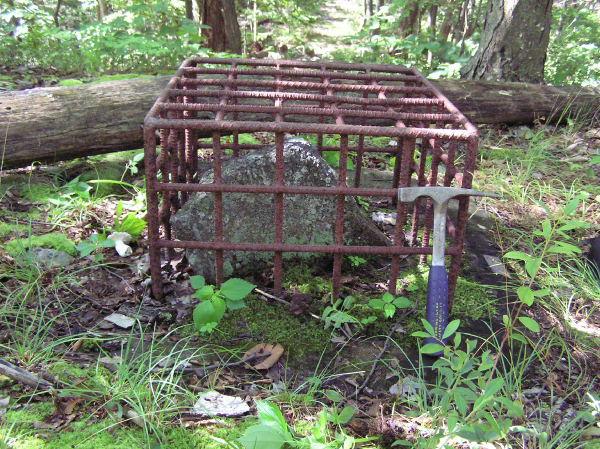 Caged nephelene syenite erratic found along the Glacial Geology
Trail in Stokes State Forest, New Jersey. This erratic was
glacially transported from a small body of syenite sometime during
the last ice age, about 18,000 years ago. The syenite outcrop lies
1.5 to 3.5 miles northeast of the erratic on the east side of
Kittatinny Mountain and about 200 to 330 feet below its summit.
Caged nephelene syenite erratic found along the Glacial Geology
Trail in Stokes State Forest, New Jersey. This erratic was
glacially transported from a small body of syenite sometime during
the last ice age, about 18,000 years ago. The syenite outcrop lies
1.5 to 3.5 miles northeast of the erratic on the east side of
Kittatinny Mountain and about 200 to 330 feet below its summit.
The bedrock in Kittatinny Mountain is the Shawangunk Formation,
a tough and very resistant quartzite and quartz-pebble conglomerate
of Silurian age, about 425 million years old. Look for rocks from
the Shawangunk Formation along the trail.
The pattern of erratics across the landscape is a record of the
direction that the glacier flowed. These syenite boulders were
transported from an outcrop two to three miles northeast on the
southeast-facing flank of Kittatinny Mountain , 300 feet below its
summit. The presence of these erratics at this site indicates that
the glacier moved south 500 to 700 west, a direction that cuts
across the more southwesterly trend of the mountain.
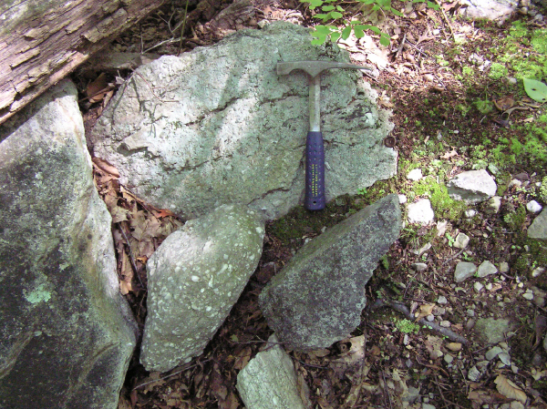 Glacial erratics at the entrance to the Glacial Geology Trail.
Light- and dark-colored clast below hammer handle is nephelene
syenite. It is a coarse granular aggregate that consists primarily
of the mineral nephelene (dark gray, short, heaxagonal crystals)
with accessory orthoclase and biotite. Light-colored clasts are
quartzite and quartz-pebble conglomerate derived from the
Shawangunk Formation. This formation underlies the higher areas on
Kittatinny Mountain forming a nearly continuous ridge from the
Shawangunk Mountains in New York to Blue Mountain in
Pennsylvania.
Glacial erratics at the entrance to the Glacial Geology Trail.
Light- and dark-colored clast below hammer handle is nephelene
syenite. It is a coarse granular aggregate that consists primarily
of the mineral nephelene (dark gray, short, heaxagonal crystals)
with accessory orthoclase and biotite. Light-colored clasts are
quartzite and quartz-pebble conglomerate derived from the
Shawangunk Formation. This formation underlies the higher areas on
Kittatinny Mountain forming a nearly continuous ridge from the
Shawangunk Mountains in New York to Blue Mountain in
Pennsylvania.
GLACIAL GARBAGE, GRABS AND GRAFFITI
Erratics aren't the only evidence of glacial globetrotting.
Glaciers modified the landscape by deeply scouring valleys,
grinding down and reshaping bedrock ridges, hills and slopes, and
by eroding and redepositing soil and loose rock. Scratches and
grooves cut into bedrock, called STRIATIONS, record the direction
of glacial flow. As ice sheets moved, they plucked up boulders,
gravel, sand, silt and clay. In some areas, these materials were
later deposited as TILL, which is an unsorted mix of material
dropped directly from glacial ice or at a glacier’s margin. Till
was deposited on the bedrock surface in sheets, in streamlined
hills called DRUMLINS, and in ridges called MORRAINES which mark
the end of an ice sheet. In other areas, the glaciers left behind
STRATIFIED SEDIMENT, which is sorted and layered material deposited
by glacial meltwater streams at and beyond a glacier’s margin.
Stratified sediment was laid down in valleys by rivers that drained
away from the glaciers, and in glacial lakes. KETTLES are
depressions in glacial drift that are made by the wasting away of a
detached block of glacial ice wholly or partly buried in drift.
Morainal kettles vary greatly in size and shape, and most contain
seasonal water and have bouldery floors.
To claim this cache: Answer the following questions, and
post your answer in your log. Tell us how many people were in your
group. (You don't have to wait for a confirmation from us to claim
the cache. We trust you!)
Describe the appearance of the syenite erratic and compare it to
the appearance of the many lighter colored bounders found along the
trail. How are the two rocks types different? Take a photograph of
yourself or your GPS receiver beside the imprisoned erratic.
****
TECHNICAL INFORMATION
Geologic Setting
The site is on the Northwestern flank of Kittatinny Mountain,
200 feet below the crest of Kittatinny Mountain. The local bedrock
is the Shawangunk Formation (gray quartzite, and white
quartz-pebble conglomerate of Silurian age), and bedding dips
steeply northwest. The upper part of the mountain along its main
ridge is characterized by many rock outcrops, weathered fractured
rock, and very thin till. Most rock outcrops show evidence of
glacial scour. They are striated and polished and exhibit a
streamlined form. In this area the Ogdensburg-Culvers Gap moraine
crosses the crest of Kittatinny Mountain and heads westward towards
the Big Flat Brook valley; its course forming a large reentrant.
The topography of the moraine lies in marked contrast to the
glacially-scoured ridge crest of Kittatinny Mountain. The moraine,
which lies about 100 feet below Sunrise Mountain Road, is an area
of thick till characterized by ridge-and-swale and knob-and-kettle
topography. Small boulder fields are common and most of the kettles
contain seasonal water. This area of morainal topography provides
diverse habitat for a wide variety of plants and animals in a very
small area.
The recessional moraines in northwestern New Jersey are as much
as 65 feet (20 m) thick, and 2500 feet (762 m) wide. Although, most
are less than 1000 feet (305 m) wide. Their surfaces are bouldery,
and they consist of poorly compacted stony till with minor beds of
stratified sand, gravel, and silt. The moraines generally have
asymmetrical cross sections and their distal slopes are the
steepest. Their distal margins are sharp, whereas the innermost
margins are indistinct. The outermost parts of the moraines are
generally marked by single or parallel sets of ridges that are as
much as 25 feet (8 m) high, 150 feet (46 m) wide, and 2000 feet
(610 m) long. Although, most are less than 500 feet (152 m) long.
Many appear to have been formerly continuous, but may have been
disconnected by collapse during melting of buried ice. Sets of
ridges are separated by elongated depressions that are as much as
20 feet (6 m) deep below their rim, 100 feet (30 m) wide, and 300
feet (91 m) long. The depressions parallel the ridges, and many
contain swamp deposits. Irregularly-shaped depressions also occur,
which are as much as 40 feet (12 m) deep, as much as 500 feet (152
m) wide, and probably were caused by melting of ice blocks. The
innermost parts of the morainal segments have fewer ridges, fewer
elongated depressions, and are marked by knob-and-kettle rather
than ridge-and-kettle topography. The morphology expressed by the
moraine at in the area of the Earthcache is typical for morainal
segments that abut thick and widespread till. In general these
segments are larger, more continuous, and have more fully developed
moraine-parallel ridges than those abutting thin patchy drift.
The course of the moraines reflects both regional and local
topographic control. Lines drawn perpendicular to their course
parallel nearby striations, indicating ice was active at or very
near the glacier margin. Well logs indicate that the Augusta
moraine where it crosses Papakating Creek valley, and the
Ogdensburg-Culvers Gap moraine, where it crosses the Paulins Kill
and Wallkill Valleys overlie ice-contact deltaic outwash (Witte
1997) suggesting that these features were deposited following a
readvance.
The lobate course of the moraines, their morphology, and
evidence of glacial readvance suggests they were formed by 1) the
transport of debris and debris-rich ice by the glacier at its
margin, and 2) penecontemporaneous and postdepositional sorting and
mixing of material by mass movement, chiefly resulting from slope
failure caused by melting ice, and saturation and collapse of
sediment. The source and mechanism of sediment transport is
unclear. Most of the morainal material appears to be of local
origin, but it is not known whether the glacier was reworking drift
at its margin or transporting sediment to its margin by direct
glacial action. Inwash is not a viable mechanism because the larger
deposits lie on mountain or ridge tops. The origin of the
moraine-parallel ridges is also unclear. These features may be push
ridges. However, due to the absence of data on their internal
structure, this premise is highly speculative.
Reference: Witte, Ron W (1998) Glacial Sediment and the Ice Age
in New Jersey, New Jersey Geological Survey Information
Circular.
This Earthcache is brought to you by the
NEW JERSEY GEOLOGICAL SURVEY
an agency of the New Jersey Department of Environmental
Protection.


Visit us at www.njgeology.org