This are a series of waypoints along the Island in the Sky Trail that will show you dolomite vs limestone, crossbedded sandstone, chert nodules, an entrenched meander, and a fault line. Handicapped access is only available to the observation deck of the visitor center. The rest of the trail is paved with steep steps at the start and end. On hot days be sure to take water and rest on the way back up.

 General instructions: All waypoints are accessable from the paved trail, do not leave the trail. All geologic formations and archeological material are protected, so do not alter them.
Dolomite – the given coordinates
The trail descends down to a layer of rock called the Kaibab Formation. The Kaibab Formation was deposited about 255 million years ago in the Permian. During this part of the Permian, this area was covered with a warm shallow ocean near the shore. As various marine animal animals died and settled to the bottom of the sea, their shells and skeletons, composed of calcium carbonate, built up a thick layer that would later become limestone. Later in very calm protected parts of the ocean, some of the calcium in the limestone was chemically replaced with magnesium to form dolomite.
Dolomite tends to be slightly harder than limestone. As a result it erodes differently. At this waypoint notice the rock next to the trail. This is dolomite. Feel the texture of the surface. (You will compare this to a limestone outcrop for the logging requirement)
Beneath the dolomite is a softer layer that has eroded out from beneath it forming overhangs. The cliff dwellings are built under these overhangs
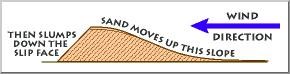 Cross-beds – N35 10.223 W111 30.601
Across the canyon and a little lower in elevation are cross-beds in the Coconino Sandstone. This sandstone was also deposited during the Permian a little before the Kaibab Formation. The Coconino sandstone was deposited about 270 million years ago when a coastal desert with sand dunes covered the area.
Graphic from USGS: http://www2.nature.nps.gov/geology/usgsnps/dune/dune.html
 The pattern in the rocks, called crossbedding, is formed by layers of sand grains as they build up into a dune then collapse. Wind piles sand up the gentle windward side of a dune. When the dune becomes too steep to support itself, it collapses creating the angled layers. This process also slowly inches the dune in the direction of the wind.
Over time, the next dune migrates over the first, burying the first and preserving them as cross-beds. The USGS Western Coastal & Marine Geology website has some downloadable movies to demonstrate the process (http://walrus.wr.usgs.gov/seds/Movie_list.html).
Transgression – Same as Crossbeds
The layers of rock reflect the gradual rise in sea level in this area during the Permian. The older sandstone at the bottom of the canyon in a coastal desert. Above this sandstone lies a limestone that formed in a shallow sea. Between the two, and not really visible from the trail is a mudstone that was deposited in an estuary or delta. This transition from a terrestrial rock type (facies) to a marine rock type (facies) records a rise in sea level called a transgression. In reality, it is very difficult to tell if the transgression is due to a rising sea level or sinking of the land.
The opposite of a transgression is a regression. In that case, the younger terrestrial facies would be on top of the older marine facies.
 Chert – N35 10.167 W111 30.630
At this waypoint look for the rounded nodules in the rock face. These nodules are made of chert, a type of rock made up of silicon dioxide. These nodules were formed around sponges that were buried in the warm oceans where the Kaibab Formation was deposited.
Limestone - N35 10.081 W111 30.606
The rock face at this waypoint is composed of limestone. At this location, Kaibab Formation remained largely unaltered and is composed of calcium carbonate. Feel the texture of the rock face and compare it to the dolomite from the previous waypoint. E-mail your comparison to me to received credit for the find.
Entrenched Meander – N35 10.211 W111 30.574
After the deposition of the Kaibab Formation about 255 million years ago, the Moenkopi and the Chinle Formations were deposited on top of the Kaibab. The Moenkopi is currently exposed in Wupatki National Monument, and the Chinle is found in the Petrified Forest National Monument.
About 80 million years ago the Western US began to be pushed up in a mountain building event that formed the Rocky Mountains. A large area of the 4-corners region (The 4-corners region is where the states Utah, Colorado, Arizona, and New Mexico all meet at their corners), called the Colorado Plateau, was uplifted as one large block. Walnut Canyon is located on the southern margin of the Colorado Plateau.
Deposition of sediment ceased and ancient rivers began to erode away layers of rock. Similar to the way the removal of cargo from a cargo ship will let the ship float higher in the water, the erosion of the rock from above the region caused the continent to float higher in the mantle. At Walnut Canyon over a mile of rock was eroded away. Some of these rocks that are missing from Walnut Canyon still exist at Zion and Bryce Canyon National Parks and the Grand Staircase-Escalante National Monument.
While eroding the softer Moenkopi and Chinle formations the rivers easily meandered across the landscape. However, once the rivers began eroding through the hard limestone of the Kaibab Formation about 6 million years ago, they no longer could change their courses and began to only erode down through the rock. This effectively froze the river’s path. At about the same time, a lava flow at Anderson Mesa blocked many drainages in the area redirecting water into Walnut Canyon. As a result this steep walled canyon formed relatively quickly, within about 1 million years. The result is this entrenched meander. An entrenched meander is a bend in a water course that is trapped in its path.
 Faults and Joints – Inside Visitor Center, No GPS reception
From the observation deck a fault can be see across the canyon. The fault is to the right of the cliff dwellings and runs up and down the cliff. The rocks on the side with the cliff dwellings has moved down relative to the rocks on the other side of the fault. This relative motion appears to follow what gravity would do, rolling down the inclined plane of the fault , making it a normal fault. If the motion were opposite making the rocks appear to be pushed up the incline, the fault would be a reverse fault.
The Island trail crosses a fault on either side of the meander.
Joints are large cracks in the rock that form when the weight of rock above it is removed, similar to an ice cube expanding when it is dropped into water, or from compression such as during uplift or mountain bulding, like a large cake that is picked up without any support.
These faults and joints create weak areas in the rock. These weak areas tended to be where the river eroded down through the rock which helped guide the river along its current course.
Logging requirements:
Send me a note with :
- The text "GCZ5H6 Walnut Canyon Geologic Sampling" on the first line
- The geocaching names of the people in your group.
- E-mail the texture difference between the dolomite and limestone outcrop, and
- Post a picture that includes you and/or your GPS, at Walnut Canyon. Additional pictures are welcome, no spoilers please.
The above information was compiled from the following sources:
- Chronic, Halka, Roadside Geology of Arizona, Mountain Press Publishing, Missolua, Nineteenth Printing, January 2005.
- NPS, Geology, Walnut Canyon National Monument Pamphlet.
- USGS: http://www2.nature.nps.gov/geology/usgsnps/dune/dune.html
Placement approved by the
Walnut Canyon National Monument