The original coordinates for this earthcache took you up to a
National Forest Service picnic area with an educational sign and a
fire lookout. Due to the reception cachers received from the
resident lookout, the coordinates have been moved. If you do head
up to the lookout anyway (
for coordinates see the Aug 2, 2007 log from geoaware), do not
mention caching and hide your gps. The picnic area is also open
from 8:30A to 4:30p.
The new coordinates take you out a dirt road on Milk Point. You
can see the rim to the east through the trees at many locations
along the way.

 The Mogollon (MUGgy-own) Rim is a 200-mile long
escarpment that marks the southern edge of the Colorado
Plateau. This escarpment is between 100 and 2000 feet high and
is a dominant geomorphological feature of the state of
Arizona. The best views are from the fire lookout tower.
The Mogollon (MUGgy-own) Rim is a 200-mile long
escarpment that marks the southern edge of the Colorado
Plateau. This escarpment is between 100 and 2000 feet high and
is a dominant geomorphological feature of the state of
Arizona. The best views are from the fire lookout tower.
There is an informational panel, picnic table, fire lookout
tower, and residence at the given coordinates. Visitors are allowed
up in the lookout tower from 8 am to 4:30 pm (as I recall). The
residence is private and off-limits.
About 80 million years ago the Western US began to be pushed up
in a mountain building event that formed the Rocky Mountains. A
large area of the 4-corners region (The 4-corners region is where
the states Utah, Colorado, Arizona, and New Mexico all meet at
their corners), called the Colorado Plateau, was uplifted as one
large block.
Relative to the surrounding areas, the geology of the Colorado
Plateau is as simple as one might hope for. Much of the area is
composed of flat-laying sedimentary layers of rock in order with
the oldest rocks on the bottom and the youngest rocks at the top.
Periodic volcanic lava flows are found on the top of these
sedimentary rocks, sometimes filling the canyons and valleys.
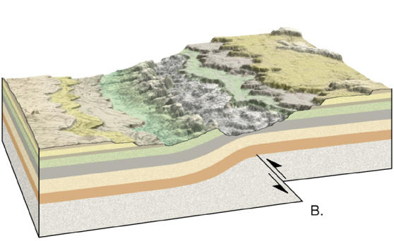 The Mogollon Rim marks the southern edge of the
Colorado Plateau. This escarpment was not formed by a fault,
but rather by the uniform erosion back from a monocline that
formed over a fault. In a monocline, layers bend in one
direction between layers of rock, kind of like a ramp. (see
the picture to the right source:Dr. Judson L. Ahern ).
The Mogollon Rim marks the southern edge of the
Colorado Plateau. This escarpment was not formed by a fault,
but rather by the uniform erosion back from a monocline that
formed over a fault. In a monocline, layers bend in one
direction between layers of rock, kind of like a ramp. (see
the picture to the right source:Dr. Judson L. Ahern ).
The fault created the monocline approximately 15 to 20 million
years ago. When the monocline first formed it was approximately 7
miles southeast of this location. Since then, the layers of rock
have been eroded fairly uniformly northeastward creating the
escarpment.
This escarpment dominates the weather patters of the region. It
creates a rain shadow as winds come up from the south, creating the
deserts of northeast Arizona and western Utah. It also creates a
daily pattern of thunderstorms that are common in the region.
Drainage patters off the rim help supply the water needed for the
region’s population. Mining and timber industries along the rim
helped settle the area.
 Logging requirements:
Send me a note with :
- The text "GCZ5FD Mogollon Rim" on the first line
- The number of people in your group.
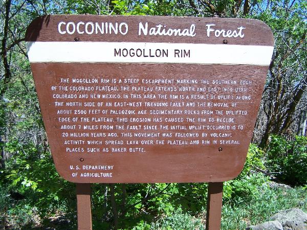
- From the informational sign at the original coordinates how
many feet of what age rock was eroded to create the escarpment?
Since the sign is not at the coordinates, see if
you can find this info on the internet. If not the sign is shown on
the right. Click it to bring up a larger image.
- For those people who want to do a little resarch, find out the
age in years of the geologic age referenced in the first
question.
The following sources were used to generate this
cache:
- Land, Sky, and People: The Southwest Defined
Edited by Joseph Carleton Wilder UNIVERSITY OF ARIZONA PRESS THE
SOUTHWEST CENTER TUCSON GEOGRAPHIC FOCAL AREAS OF THE SOUTHWEST
http://digital.library.arizona.edu/jsw/3403/geog.html
- Dr. Judson L. Ahern
http://geophysics.ou.edu/dynamic/notes/structure/structure.html
- Chronic, Halka, Roadside Geology of Arizona,
Mountain Press Publishing, Missolua, Nineteenth Printing, January
2005.