 A ma soeur...
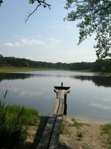
L'étang de Montperché ou Montpercher:
Le but de ce geocache est de vous faire découvrir un petit étang
solognot situé au sud de Chambord, dans la forêt domaniale de
Boulogne. Vous y trouverez des bancs, des tables, pour réaliser un
pique-nique en famille.
Trois variantes pour ce geocache:
- Vous êtes pressé, ou en
famille:
A 2,2 km après le centre ville de
Thoury en
direction de
Dhuizon , prendre sur la droite l'allée forestière de Crouy et
rejoindre le parking aux coordonnées suivantes: N 47°35.386'
E 001°36.021'. Il ne vous reste plus qu'à rejoindre l'étang de
Montperché et la cache aux coordonnées ci-dessous.
- Vous êtes marcheur ou à VTT (3
km - aller):
A partir de
Dhuizon, rendez-vous au waypoint suivant: N 47°35.317' E
001°37.853' ou vous pourrez garer votre véhicule. Attention! cette
petite route n'est pas très facile à trouver dans Dhuizon (A partir
du centre ville, prendre la direction Thoury, et à 80m sur la
gauche (avant les dos d'ane des écoles), vous trouverez cette
petite route). Prenez cap au 300° et suivez le chemin de grande
randonnée (GR3c) balisé en rouge et blanc, jusqu'à ce waypoint: N
47°35.440' E 001°37.440'. Vous rentrez maintenant dans la forêt
domaniale de Boulogne. Continuez sur le chemin en suivant toujours
le balisage rouge et blanc du GR3c. Vous allez bientôt atteindre
l'étang de Montperché et la cache.
- Vous êtes bon marcheur ou à
VTT (4,3 km -aller):
Sur la route de
Dhuizon à
Thoury , à 1,5 km après
le centre-ville, vous trouverez sur la droite de la route le
waypoint: N 47°35.897' E 001°38.583' ou vous pourrez garer la
voiture. Suivre le balisage rouge et blanc du GR3c en direction du
waypoint: N 47°35.317' E 001°37.853'. Prenez cap au 300° et suivez
le chemin de grande randonnée (GR3c) balisé en rouge et blanc,
jusqu'à ce waypoint: N 47°35.440' E 001°37.440'. Vous rentrez
maintenant dans la forêt domaniale de Boulogne. Continuez sur le
chemin en suivant toujours le balisage rouge et blanc du GR3c. Vous
allez bientôt atteindre l'étang de Montperché et la cache.
La cache:
Vous la trouverez sous une
petite souche, légèrement en contre-bas de la chaussée de
l'étang à ces coordonnées:
- N 47°35.203'
- E 001°36.058'
Bonne chasse!
English version:
To my sister...
L'étang de Montperché or Montpercher:
The objective of this geocache is to bring you
into a tipical Sologne site. You'll discover a pond not far from
the famous Chambord, into the state forest of Boulogne. You'll find
picnic area.
Tree way to find this geocache:
- In hurry, or with all the
family:
After 2,2 km from the center of
Thoury in
the direction of
Dhuizon , take on the right the lane "Allée forestière de
Crouy". You'll find a parking here: N 47°35.386' E
001°36.021'.
- You want to walk a bit (3 km -
to go):
From
Dhuizon, find this waypoint: N 47°35.317' E 001°37.853' .
You'll stop the car there. It's not easy to find in Dhuizon. Go
300° and follow the GR3c (red and white indication) to this
waypoint: N 47°35.440' E 001°37.440'. You are now in the state
forest. Follow the red and white indications and you'll find the
Montperché pond.
- You want a longer walk or you
like riding in forest (4,3 km - to go):
On the road from
Dhuizon to
Thoury , you'll find a
parking at this waypoint
waypoint: N 47°35.897' E 001°38.583'. Follow the red and white
indications to this waypoint N 47°35.317' E 001°37.853'. Go 300°
and follow the GR3c (red and white indication) to this waypoint: N
47°35.440' E 001°37.440'. You are now in the state forest. Follow
the red and white indications and you'll find the Montperché
pond.
The cache:
You'll find it easely under
a
small stock, on the background of the pond at these coordinates
coordonnées:
- N 47°35.203'
- E 001°36.058'
Have fun!