This is the bridge that appears on the 2005
Indiana Geocoin.
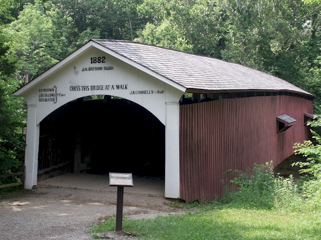
Narrows Bridge
Built in 1882 by Joseph A.
Britton
Location: Located on east side of Turkey Run State Park,
next to Lusk Mill site.
Size: The length of this bridge is 121' +8' +8'. The
width is 16'6" with 12'6" of clearance. It has a Burr Arch 1 span
truss. The foundation is hewn stone.
Original Cost: $3,400
Repair/Restoration History: Replaced Salmon Lusk’s
Bridges of 1840-1847 and 1847-1875. Bypassed 1960. Rebuilt in 1977
by State of Indiana Department of Natural Resources.
Bridge History: The previous Lusk Bridge was destroyed in
1875. When the Parke County Commissioners decided to replace the
bridge, iron bridges were becoming popular. The first bids, opened
on August 24,1882, included: Smith Iron Works - $13.00, $15.50,
$21.00 per lineal foot; Wrought Iron Bridge Co. - $20.00, $21.65
per lineal foot; King Iron Bridge Co. - $21.20 per lineal foot;
Columbia Bridge Works - $24.00 per lineal foot; G.F. Haynes (Wood)
- $20.00 per lineal foot; J.A. Britton (Wood) - $3,750 total.
All Bids were rejected.
My wife's great-great grandfather, J.A. Britton was later
awarded the contract for $3400 at the age of 45. This bridge has
been acclaimed as the first in J.A. Button’s illustrious covered
bridge career. Some purists have criticized the pointed arch
joints, J. A. Britton built a Billie Creek Bridge in 1880, but it
was probably an open bridge. The last bridge J.A. Britton built was
the Nevins Bridge at the age of 83 he later died at the age of
91.
Joseph A. Button’s first wife died as he was working on the
Narrows Bridge. He met his second wife, who was living at a farm
not far from the narrows, while working on the bridge.
The Narrows bridge is one of the most photographed covered
bridges in the state. It is accessible from a public road, three
Turkey Run State Park hiking trails, and canoe trips on Sugar
Creek. The famous bridges of Turkey Run include two covered bridges
still standing over Sugar Creek: Narrows, and Cox Ford. There were
three earlier bridges at the Narrows and the Turkey Run Bridge,
located near Indiana Highway 47 and the Turkey Run State Park
entrance. Then there is the famous swinging bridge over Sugar
Creek.
Sugar Creek was once called Rock River because of its size and
rocks. The Pottawatomie Indians called it Pungosecone which may be
translated as "the waters of many sugar trees" or "ashes at mouth
of stream".
Here is a link to Turkey Run State Park ( Turkey Run State Park ).
The cache is a micro, which I'm not real fond of but it was the
only thing that would work in this location witout a permit from
the DNR to place it on park property. Hopefully in the future I can
get a permit and move this into an ammo container on the park
property but until then, this will work. You can access the cache
and bridge without paying to get into Turkey Run State Park by way
of a county road on the east side of the park. If you have the time
to visit the park and hike the trails, I'm sure you will enjoy it.
Please hide the cache as well or better than you found it. There is
a Sacagawea dollar in the cache for the first one to find. Also,
don't forget to bring your own pen.
Make sure you visit Turkey Run Stash while in the area, located
just west of the bridge. Turkey Run Stash is the oldest
unachieved cache in the state of Indiana!