K cache muzete vyrazit z Pekla, z Ceske Cermne a nebo z Noveho Hradku po turistickych znacenych cestach. Hledani indicii a cache by nemelo presahnout hodinu. Cesta na misto bude trvat ruzne, podle zvoleneho vychoziho bodu. Pro ziskani souradnic cache musite navstivit 4 mistecka neprilis vzdalena od sebe. Vysledne souradnice cache pak spoctete takto:
N 50º 22,(D)(C)(A+D)' E 16º 12,(B+C)(C-A-B)(D)'
This cache will bring you to romantic places in the valley called Peklo of Olesenka river.
The best access to the cache is from the small village of Peklo, Novy Hradek or Ceska Cermna by marked tourist trails. You will have to visit four places - four stages of the multicache - which are not very far from each other. It will take you about one hour to find this multicache. The final coordinates are:
N 50º 22,(D)(C)(A+D)' E 16º 12,(B+C)(C-A-B)(D)'
|
N 50º22,798´ E 16º12,462´
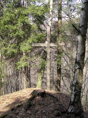
Bily kriz (vekem uz bily neni).
Letopocet je vyryt do betonku u paty krize.
AXXX
|
|
N 50º22,798´ E 16º12,462´
White cross (it's not white anymore).
The year is inscribed into the concrete by the foot of the cross.
AXXX
|
|
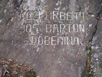
N50º22,787´ E16º13,505´
Bartonuv kamen, ktery je uprostred krizovatky lesnich cest a byl vztycen na pocest vyroci, o kterem se doctete na kameni samotnem a zaroven slouzi jako hranicni kamen Bartonova panstvi. Do kamene jest vytesan napis a na boku kamene naleznete dva letopocty.
BXXX
XXXX
|
|
N50º22,787´ E16º13,505´
Stone called Bartonuv kamen stands in the middle of a cross roads. It is a boarder stone of Barton demesne. Two years are inscribed into the side of the stone.
BXXX
XXXX
|
|
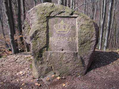
N50º22,633´ E16º12,566´
Louisen platz
Toto misto oznacene Louisen Platz souvisi s majiteli nachodskeho panstvi, knizaty Schaumburg – Lippe. Pomnik nese knizeci korunku a jmeno Louise. Princezna danska, Louise (* 17.2.1875 + 4.4.1906), byla prvni zenou Bedricha knizete Schaumburg – Lippe. Letopocet na pomniku je rokem jejich snatku.
XCXX
|
|
N50º22,633´ E16º12,566´
Louisen platz
Louise was a danish princess, first wife of duke Schaumburg Lippe. The year of their wedding is inscribed into the stone.
XCXX
|
|
|
N50º22,541´ E16º12,947´
Bartonova skala,(mistni nazev pro skalu) do niz je vytesan napis a letopocet
XXXD
vystavby cesty usnadnujici praci v lese a tezbu dreva. Cestu nechal stavet majitel panství a Novomestskeho zamku Josef Barton z Dobenina. Zde si muzete precist neco o historii jejich rodu.
|
|
N50º22,541´ E16º12,947´
Bartonova skala (local name of the rock) where you can find inscription and a year
XXXD
The road was built by the owner of Nove Mesto demesne in this year to make timber harvesting easier.
|