Canal de Nante à Brest - Rigole d’Hilvern Traditional Geocache
Canal de Nante à Brest - Rigole d’Hilvern
-
Difficulty:
-

-
Terrain:
-

Size:  (small)
Please note Use of geocaching.com services is subject to the terms and conditions
in our disclaimer.
En 1806, Napoléon 1er decide la realisation du Canal de Nantes à
Brest pour des raisons stratégiques: les Anglais contrôlent les
mers, ce canal doit permettre de désenclaver les arsenaux Bretons
et la Bretagne intérieure.
Les travaux débutent en 1811 et s’achèvent en 1842. Le Canal
va favoriser le développement économique par le transport de
produits importés (épicerie, vin,engrais, chaux, sable de Loire
etc) et exportés (bois, cereals, pommes de terre etc) Cette
activitéest fortement ralentie à partir de 1923, en raison de la
construction du barrage de Guerlédan et périclite dans les années
1970, relayéepar la navigation de plaisance.
Le canal traverse les 3 cantons du Pays des Rohan sur près de 70
kms, avec plus de cent écluses, don’t 12 noyées par la
retenue du barrage de Guerlédan.
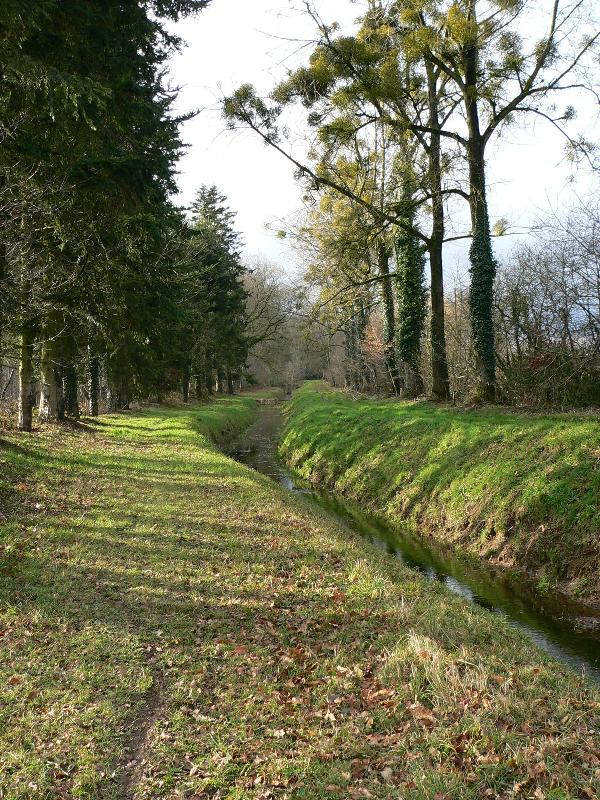
La rigole d’Hilvern, creusée de 1828 à 1838, a été conçue
pour alimenter le canal de Nantes à Brest. Alors que Bosméléac et
Hilvern ne sont distants que d’une vingtaine de Kilomètres à
vol d’oiseau, c’est sur 62,5 kms et une pente de
0,3mm/metre que va être réalisé cet ouvrage. L'eau fournie au canal
à partir du rigole a été remplacée en 1990 par l'eau pompée du
fleuve Blavet.
In 1806 Napoleon 1st decided to have a canal
built between the ports of Nantes and Brest for strategic reasons.
The sea being under English control, the canal would make the
Breton naval dockyards and the centre of Brittany, less
isolated.
They started digging the canal in 1811 and it was completed in
1842. It boosted the local economy with the transportation of
imported goods (spices, wine, fertiliser, lime and sand from the
Loire etc) and also exporting produce (wood, cereals, potatoes
etc.) However in 1923, the building of a dam at Guerlédan was a
severe blow to the canal trade and in the 1970’s this
activity came to a halt. Trade has now been replaced by leisure
boating.
The 44 mile long stretch of the canal, runs through the three
smaller districts of the Pays des Rohan. There are more than 100
locks on this section, 12 submerged under the water of the
Guerlédan lake.
The rigole d’Hilvern, dug between 1828 and 1838, was
conceived to feed the Nantes to Brest canal with water from a
specially created lake at Bosméléac. Whereas Bosméléac and Hilvern
are only a score of kilometres apart, (as the crow flies), the
rigole takes 62.5 kms (39 miles) to cover the same distance, (i.e.
3 times as far) with a drop of 0.3mm per meter. The rigole’s
water supply was replaced in 1990 by water pumped from the river
Blavet near Porzo.
Additional Hints
(Decrypt)
Qh fgngvbaarzrag, pebvfrm yr pnany, gbhearm à tnhpur yr ybat qh unyntr whfdh'à pr dhr ibhf neevivrm à yn wbapgvba qh evtbyr rg qh pnany. Fhvirm yr pôgé qebvg qh evtbyr. Yn pnpur rfg fbhf ha gebaçba q'neoer.
Sebz gur cnexvat, pebff gur pnany, ghea yrsg nybat gur gbjcngu hagvy lbh neevir ng gur whapgvba bs gur evtbyr naq gur pnany. Sbyybj gur evtugunaq fvqr bs gur evtbyr. Gur pnpur vf haqre n snyyra gerr gehax.