Late day, April 18, 1775, General Gage, in an effort to forestall insurrection, sent forth approximately 800 Regulars to the west from Boston. The Colonials heard that the mission was going to be two-fold. First, the Regulars were to arrest the firebrand rebel-rouser Sam Adams and his compatriot John Hancock, the wealthiest man in Massachusetts Bay Colony. (We have strong, but unsubstantiated, suspicions that Hancock was underwriting the costs of the colonial uprising.) Second, they were to locate and confiscate arms and powder in the Town of Concord. The soldiers were specifically instructed to be peaceful and not to instigate any problems.
This action was leaked to the Colonials, perhaps by General Gage’s American-born wife. After the Old North Church flashed the lantern twice, Paul Revere and William Dawes sped through the countryside to warn Sam Adams, John Hancock and the Concord Minutemen. Adams and Hancock were staying at the Hancock-Clark Parsonage, at the coordinates above, along with Dorothy Quincy (Hancock’s fiancée), Hancock’s Aunt Lydia, Reverend and Mrs. Clark, and 8 of the 12 Clark children. Revere and Dawes arrived with their warning about midnight and then rode on to warn the men of Concord.
|
Around 5 a.m. the following morning Revere returned to the Parsonage to discover Adams and Hancock still there. The men were looking forward to a breakfast of the first brook salmon of the season, a real delicacy. He railed at them and they shortly left, without breakfast. They journeyed about 3 miles to the home of James Reed, which was located where the Burlington Mall now stands. From here they sent back to the Hancock-Clark residence for their salmon.
|
|
In the meantime, Major Pitcairn and six companies of light infantry had hurried ahead of the main British force. They arrived at the Lexington Town Green to find 40-60 armed Colonials facing them down. The leader of the Colonials realized the impossibility of their situation and ordered a retreat.
But before the Colonials could complete their retreat someone, no one knows who, fired the first shot, it got out of hand and eight Colonials were killed, many of them shot in the back. They are buried at a memorial on the Green. Dolly Quincy and Aunt Lydia witnessed the carnage on the Lexington Town Green from a second story window of the Parsonage.
As soon as the British left, Dolly and Aunt Lydia hurriedly hitched up the horses, grabbed the salmon and rode to join Adams and Hancock at the Reed house. The entire party then sped about a mile further to the Sewall Parsonage.
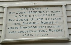
The Hancock-Clark Parsonage main room, containing many historical treasures, can be viewed daily from 10 - 4 during the warm weather. The HC house highlights the events of the Paul Revere's ride and has a 14-minute movie to introduce the seeds of the Patriot's Day revolt. A full tour is given on the hour at $6 per person. Limited parking is available on-site, behind the house. Or for $10 you can tour all three Lex Hist Soc buildings: additionally, Buckman Tavern (tours on the half hour from 10 - 4) and Munroe Tavern (tours on the hour) first tour is at 1 and final at 4. Munroe Tavern gives the British side of the Patriot's Day story.
|
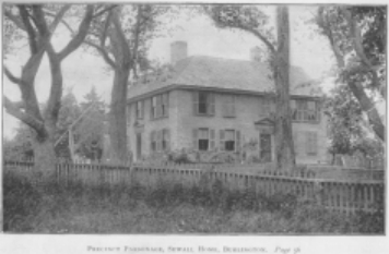
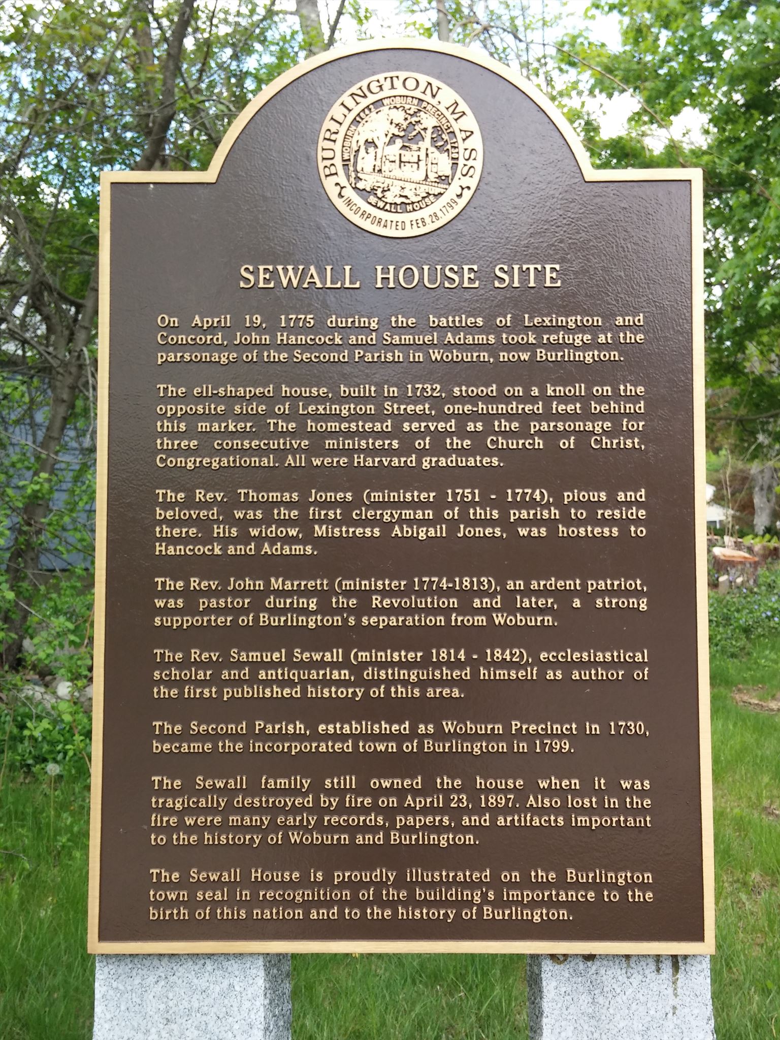
Next we travel to the location of the Sewall Parsonage. Unfortunately it burned down in 1897, and we can only visualize it from its photos. Also, it is pictured on the Burlington Town Seal because of its historical relevance. The Burlington Historical Committee has erected a commemorative plaque here, across the road from where the Parsonage sat.
|
|
To find the Sewall Parsonage location first find a brass plaque next to the Hancock-Clark front door (not museum entrance). There is a year listed at the bottom of the plaque. ADD the first 2 digits to 42° 29.966 to get latitude. SUBTRACT the 3rd and 4 digits FROM 71° 12.285 to get longitude.
|
Once at the Sewall Parsonage, Adams, Hancock, Dolly and Aunt Lydia were warmly greeted by Reverend Marrett and Madame Jones, the widow of the former minister Rev. Thomas Jones. (It was common for widows of clerics to remain under the aegis of the Parsonages.)
Madame Jones began to prepare a fine lunch for her guests, with the brook salmon as its centerpiece, when an unidentified individual burst in saying the British were coming and that Adams and Hancock would soon have the “enemy at their heels”. Neither Adams nor Hancock could have known that this was a false alarm so they departed in great haste. After having missed breakfast, now they were without lunch.
|
|
We can only presume that Dolly, Aunt Lydia and Madame Jones, who were left, finally enjoyed the salmon.
|
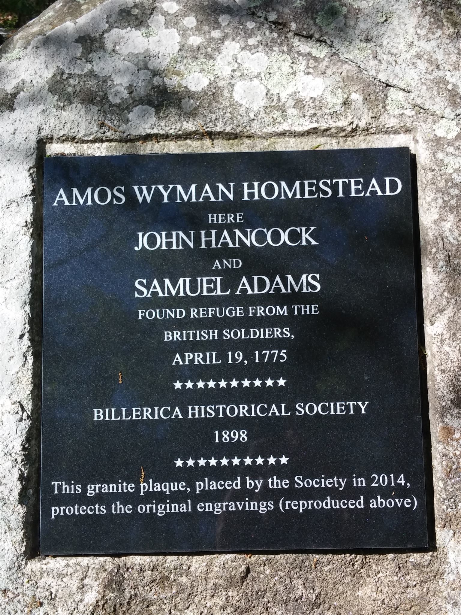
After quickly hiding Hancock’s “gilded carriage”, Rev. Marrett and Cuff Trot, Madame Jones’ slave, guided Adams and Hancock through woodland paths (which unfortunately no longer exist) about 2 miles to the poor farmstead of Amos Wyman.
By this time Adams and Hancock must have been famished. They indicated that some food would be appreciated and Mrs. Wyman did what she could. She took down a wooden platter from atop a cupboard. It was certainly not the china they would have had at either of the Parsonages. Yet she laid before her two distinguished guests what she had: cold boiled salt pork, cold unpeeled boiled potatoes and homemade coarse brown bread. They undoubtedly “dug in” with gusto – even if it wasn’t salmon. Adams and Hancock spent the night at the Wyman home and moved on the next day.
Later, after the war, Hancock (the first Governor of the Commonwealth of Massachusetts) appreciatively presented Mrs. Wyman with a cow - an item of great value to a small farmer.
|
|
The Billerica Historical Society has placed a plaque where the homestead once stood. To find this plaque, pictured above, take the house number (on the house) of the home across the side street from the Sewall House Site plaque. Add that house number to each of the following: 42 30.778, 71 14.081. The result will bring you to the plaque, with the archeological dig site nearby.
The easiest access to the public site is from a semi-public Suite parking area. From the plaque coordinates, subtract .043 from both the latitude and longitude to find a walkway leading a short distance to the main public pathway on your right. This pathway will lead you to the plaque.
The cache is well-hidden within sight of the plaque. In fact it is minus .002 North and plus .001 West.
Do not wander too far afield, since there is a gun club nearby (which donated this 2-acre property to the Town of Billerica).
Bibliography