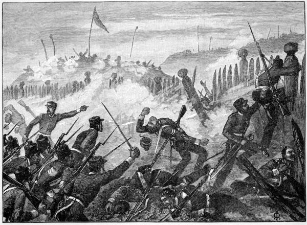
Attacking the Rangiriri Pa
This is an 11 stage multi-cache that will suit people who have an interest in New Zealand history and are keen on a leisurely drive south from Auckland to the Waikato. It is not physically demanding nor is it intended to be particularly difficult but there is quite a lot of driving involved and short uphill walks to some of the sites. To give you an idea of how far you will go the route takes you in a southerly direction generally following Hwy 1 and Hwy 39 finishing up at approximately 38 degrees south.
A number of the waypoints are accessed off the VERY busy State Hwy 1 so you will need to take particular care when exiting and re-entering the traffic. For safety reasons (i.e. avoiding U turns on the expressway) the road names for the access to some of the waypoints are given in the notes.
Definitely kid friendly and you never know they might even learn something at the same time?
EDIT: Jan 2013. The Historic Places Trust have developed audio guides for the main battle sites that you will be visiting as part of this cache. They can be downloaded as a 50MB zip file containing the MP3 files so you can listen to them either on your phone or any other MP3 player as you visit each site. You don't have to do this to complete the cache but it would significantly enhance the experience. The audio guides can be downloaded for free at: http://www.hamiltonwaikato.com/the-waikato-war/downloads
To set the scene:
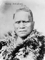
The year is 1863. Maori farmers in the Waikato raise much of the food upon which Auckland depends. The Taranaki war is all but over but tensions are simmering. Auckland and New Plymouth are spilling over with new colonists but Maori are becoming very resistant to selling land. This new tribal unity is largely as a result of the installation of a Maori King, Potatau, some five years earlier. Most European colonists view supporters of the king movement, or Kingitanga, as disloyal to the British Crown.
Mistrust between Maori and the Europeans has grown and settlers have fortified their farmhouses and other buildings in the South Auckland area as refuges in the event of Maori attack. There is the odd skirmish and deaths on both sides. Rumours are circulating that Maori may launch an attack on Auckland itself.
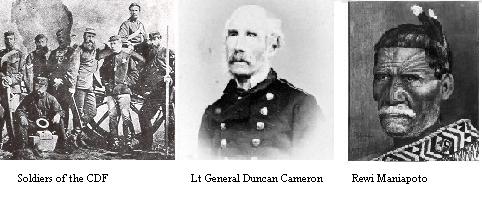
Governor Grey is determined to put down what he sees as a threat to British authority represented by the Kingitanga and extend the colonial government's authority over Maoris outside the effective reach of the law. He builds a military route, the great south road, and redoubts through the bush from Auckland to north Waikato. He convinces the British government not to withdraw the troops brought to NZ for the Taranaki war and further strengthens his force with sailors, marines, two units of colonial troops (Colonial Defence Force and Forest Rangers), Auckland and Waikato militias and Maori loyal to the crown (Kupapa).
On 9 July 1863, Grey orders that all Maori living between Auckland and Waikato be expelled south of the Mangatawhiri Stream, which marks the northern Kingitanga boundary, unless they take an oath of allegiance to Queen Victoria. Most ignore this.
The invasion of the Waikato begins on 12 July 1863 when Grey orders Lt-General Duncan Cameron and his force of combined regular and volunteer soldiers across the Mangatawhiri Stream.
Collect the answers to the questions as you go as you will need them to find some waypoints and the final cache.
Waypoint 1 : Travelling south from Auckland on State Hwy 1 take the Pokeno exit and stop at S37 14.844, E175 01.518. As at August 2005 this site was a "work in progress". It will be interesting to see how it develops.
Q1: This site has a two word name. Y = (number of letters in the second word ending in "t") minus 3
Waypoint 1a (Optional): Get back onto Hwy 1 and head south. Take the first exit LEFT onto Pioneer Rd. At S37 15.709, E175 02.621 you will have just crossed the unmarked Mangatawhiri Stream which marked the Kingitanga "border" in 1863. Continue on down Pioneer Rd until you rejoin Hwy 1.
Waypoint 2: 2.1 km south of Mercer turn left onto Oram Rd. Waypoint 2 is at S37 17.564, E175 03.624. Take care as in winter the track up the hill can be slippery and muddy. READ THE NEXT INSTRUCTION CAREFULLY: The sign here mentions a nearby redoubt. Go to this redoubt THEN find the answer to Q2.
Q2: At the redoubt, E = the number of letters in the last YELLOW word on the sign beginning with "s"
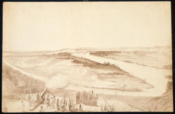
40-pounder Armstrong guns firing on Meremere Pa from the Whangamarino Redoubt
Waypoint 3: Get back onto Hwy 1 and take the first left (Springhill Rd) past the old Meremere power station. Waypoint 3 is at S37 19.110, E175 04.197
Q3: Z = (the November day referred to on the sign) plus one.
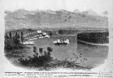
An exchange of fire between the gunboat "Pioneer" and the Meremere defenders
Waypoint 4: S37 25.649, E175 07.772. Some excellent new signage installed here in January 2013. While you are on site, take note of ridge to the east of Hwy 1 where a 900-strong force attacked from, the Waikato River where the Avon and Pioneer gun boats attacked from, the slopes on the south side of the Maori defensive line where 520 men from the gun boats landed and attacked from and the nearby lake where Maori escaped to.
Q4: W = Number of Pohutukawa trees within the fenced area
Waypoint 5: S37 25.904, E175 08.033. If you get the chance there is an excellent audio-visual on the Waikato War across the road at the privately owned museum/tea rooms (small charge for this). No need to visit the museum to complete the cache though.
Q5: One stone in this yard was erected by General Cameron in memory of his orderly who was killed.
H = (The orderlies Regiment) - 1
Waypoint 5a (Optional): Continue on down Hwy 1 to S37 39.779, E175 09.244. This will take you to the carved gates of the Turangawaewae Marae which is home to the present day Maori King - the Kingitanga movement has survived to the present day. Please note that the Marae itself is private property and you will need to get permission should you wish to enter. There is a phone number on the gate.
Waypoint 6: S37 H.795, E175 08.(Y+W)46
Q6a: C = thickness of the iron in millimetres
Q6b: D = (beam of the ship in meters) plus 2
Q6c: B = number of gun turrets
Waypoint 7: The next couple of waypoints are slightly out of order in terms of the chronological progression of the invasion but going this way does shorten the driving distance considerably. At Ngaruawahia turn off Hwy 1 onto Hwy 39 then head to Pirongia S37 59.401, E175 11.872
Q7: V = (number of letters in the large RED word at the top of the sign ending in "r") - 1
Waypoint 8: S37 59.642, E175 11.880
Q8: X = (Number of planks on the bridge) divided by 2
Waypoint 9: From Pirongia head to Te Awamutu. S38 00.543, E175 19.663.
Q9: A marble memorial close by has the inscription: "In memory of the Maori …". Q = number of letters in the word AFTER "Maori" in this inscription. The word we want ends in "s"
Waypoint 10: S38 00.884, E175 22.589. Cameron's masterstroke in the war was secretly outflanking (at night), the Paterangi line which comprised many kilometres of impregnable trenches and was garrisoned by around 1800 Maori warriors then attacking the undefended location here. A number of civilians were killed in unsavoury circumstances which became a controversial point of the war.
Q10: A = (The last digit in the year this building was opened) - Q
Final Waypoint. The cache. S38 AB.CDE, E175 VW.XYZ.
Checksum of all answers = 99
The cache is in a 200ml camo painted container
Congratulations - you have done it!
There are plenty of other places we could have visited and we could have gone into the land confiscations and the Raupatu land settlement but we had to stop somewhere! However, there are a couple of other places not too far away that may be of interest:
S38 00.682, E175 19.422 (Te Awamutu Museum) - has a good collection of Waikato War artefacts.
S38 02.337, E175 20.726 Rewi Maniapoto memorial at Kihikihi
I had to do a bit of reading to put this one together. There is one book in particular that I would like to acknowledge; "The Waikato War of 1863-1864 A guide to the main events and sites" by Neville Ritchie as providing a valuable reference.