An artesian, or free flowing well, occurs when ground water
becomes pressurized and forces its way to the surface. Pressure is
created when the ground water recharge zone is at a higher
elevation than the head of the well. This forces water to flow from
the well without pumping. The word artesian comes from the town of
Artois in northwestern France, where Carthusian monks drilled the
first such well in 1126.
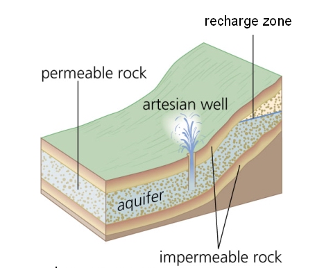 Figure 1: How an artesian well works
Figure 1 illustrates the geologic conditions needed for an
artesian well to flow. Artesian wells are most always located at
the base of a high hill or mountain – the situation we see here.
The wellhead is at about 715 ft elevation, while the hill
immediately to the west (the ground water recharge zone) is nearly
200 ft higher. This elevation difference provides the pressure that
drives the water in this well.
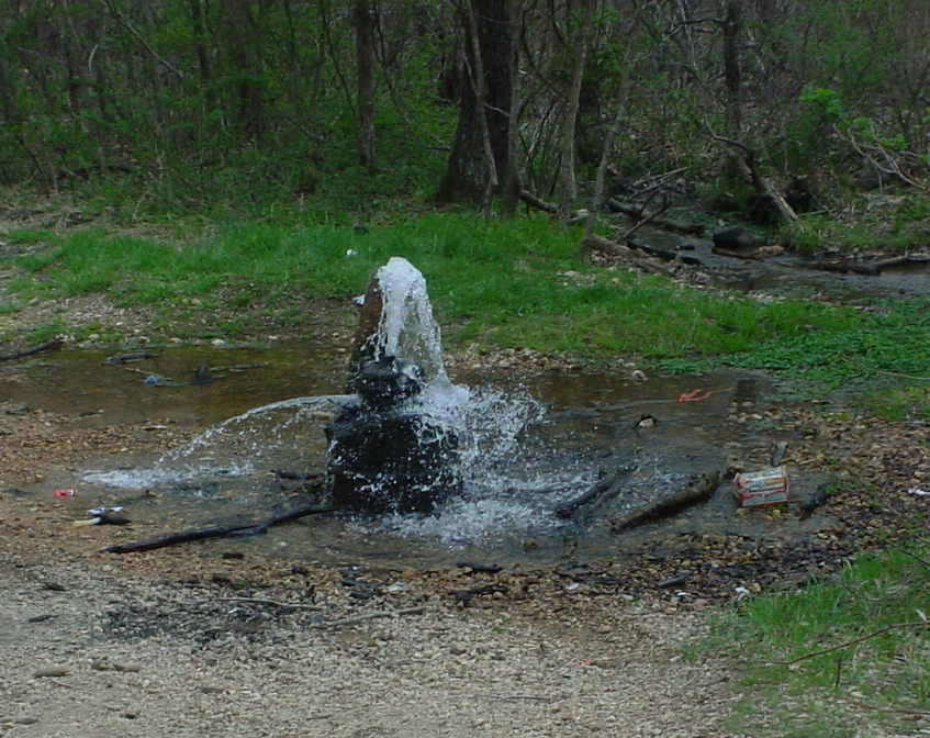 Figure 2: The well
This artesian well (see Figure 2) is located in Mark Twain
National Forest. It was drilled by National Lead Company in the
early 1950s in the search for lead and zinc deposits to feed their
Fredericktown smelter. No metals were intercepted in this well, but
because it produced such copious quantities of cool, pure water,
the Forest Service purchased the well casing and left it open for
public use.
I first became aware of this well in about 1980. It has produced
more than 100 gallons of water per minute for over 50 years. There
is watercress growing nearby. It loves the cold, slightly alkaline
water and has a tangy, peppery flavor.
FINDING THE CACHE
To make this cache muggle-resistant, I've ditched the metal tag.
Stand at the well (or as close as you dare) and project the
following waypoint:
· BEARING = 249.7 DEG (TRUE) · DISTANCE = 1.24 MI
This is where you'll find the cache. It's an ammo box placed at
the base of a tall pine tree near the intersection of a road and a
trail. It contains some nifty items and the logbook. If the road is
dry you can drive right to the cache with most any vehicle. The
first half-mile is pretty steep (grades of up to 11%), so if the
road is muddy you may have to walk, or use 4WD.
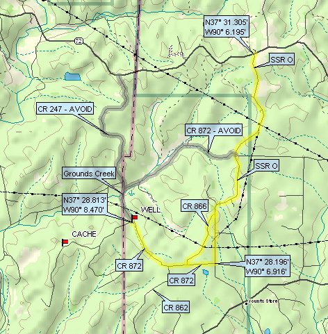 Figure 3: How to get here (without getting stuck)
DRIVING DIRECTIONS (see Figure 3):
This is more than just a suggested route. It’s actually quite
IMPORTANT that you approach the well by this route to avoid getting
stuck.
1. Take MO Rt 72 to Hwy O · The intersection is approximately 12
mi east of Fredericktown at 37 N 31.305, 90 W 06.195 2. Take Hwy O
south to County Road 872 (4.11 mi) · This intersection is at 37 N
28.196, 90 W 06.916 · CR 866 will also get you to CR 872 3. Take CR
872 west to FS 2137 (1.86 mi) · The well is visible from the CR
872/FS 2137 intersection
WARNING! (ACHTUNG!)
Do not try to approach the well from the north on CR 247! This
will require you to ford Grounds Creek (at 37 N 29.236, 90 W
08.644). You may get stuck in this creek, even with 4WD. The route
to take is highlighted in yellow (see Figure 3). The routes to
AVOID are highlighted in grey.