The Mont Alto Picnic Ground of today has a rich history which began
on April 6, 1883 with the Greeley, Salt Lake and Pacific narrow
guage railroad. The RR's first train, nicknamed "Switzerland
Trail", left Boulder for Penn Gulch (later named Sunset). The route
went up Fourmile Canyon to Sunset where wagons completed the
journey past Mont Alto to the mining operations in Ward.
In 1897 the Colorado and Northwestern Railway extended this
narrow guage railway north to Ward and south to the Eldora,
Nederland, Cardinal and Caribou areas. To serve these mining
communities an order was placed for three powerful
locomotives, to be numbered 30, 31 and 32.
(Boulder owns Engine #30 today). The trains during this period
usually carried mining supplies and ore to the mills.
When the mines started to play out this railroad retooled the
line as a tourist route and renamed itself "The Switzerland Trail
of America". "One need not go to Switzerland for sublime mountain
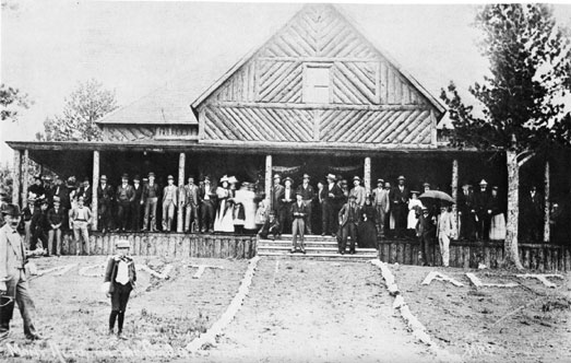
scenery", touted the railroad ads. The line built a large lodge at
Mont Alto that was used for concerts and dances. On the day the
park opened, the city of Boulder closed for business so that
everyone would have a chance to go to the "open house". Tourists
packed the trains (which also carried kegs of beer packed in snow)
for a fun filled day of picnicking and baseball. Music and dancing
was enjoyed long after sunset.
This historic railway was bought in 1909 by The Denver Boulder
& Western. The trains ran for several more years but finally
the line closed down in 1919. Today the rails are gone but the
route continues as a forest service road (FDR327) to be enjoyed by
modern explorers. The Mont Alto Lodge is also gone... Today it's a
picnic ground with a chimney and fountain to remind us of the "old
days".
To enjoy the whole trail start at N40°01.069 W105°30.551 (Just
north of Nederland) and drive east to Sugarloaf Mountain. At the
Sugarloaf Mt. parking area turn left and drive W by NW to the town
of Sunset. Turn right then left again on FDR327 and follow the
railroad bed to Mont Alto.
My 4x4 club enjoyed a historical trip to
the area in 2001. Hikers and bikers also share the Switzerland
Trail today.