Physikalische Daten
| mittlerer Radius |
[km] |
6371 |
| Dichte |
[g/cm³] |
5,515 |
| Masse |
[10²³kg] |
59,736 |
| mittlere Entf. zur Sonne |
[AE] |
1,0 |
| Umlaufzeit |
[d] |
365,256 |
| Rotationsdauer |
[h] |
23,934 |
| Neigung der Achse |
|
23,45° |
| Anzahl Monde |
|
1 |
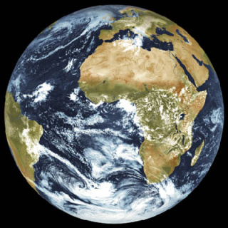
This cache is one in a series of caches representing objects in the Solar System in a scale of 1:100,000,000. That means that 1000 km in nature are shown as 1 cm in the model. The Earth would be a sphere of 12.7 cm diameter. In the cachebox is a picture showing you this size of Earth.
Stage 1 represents the perihelion position of Earth, that means the position with the shortest distance to the sun. The Earth reaches this position on January 2.
Stage 2 is the Position of the Earth on April 14.
The final stage is at the position with the greatest distance to sun (aphelion). This Position is reached on July 5.
At the first stage you find (no more!) a group of 3 trees. Behind one of them (an ex tree) you find a concrete thing like a tin can but grey and solid showing you the coordinates of the next stage.
You will find a signpost.
The distance to "RK" is X,A km
The distance to "GH" is C,X km
The distance to "SP" is D,B km
Then calculate : E=A+C; F=B-A
The final stage is at N50°AE.ADD E008°CF.FAC
Please notice the coordinates of the final stage.
You need them to find the SolSys bonus cache.
The Sun is represented by the telecommunication tower on top of the Feldberg.
see Geocache GCM7HZ: Feldberg-SolSys: Sonne
Dieser Cache gehört zu einer Serie von weiteren Caches, die Objekte des Sonnensystems in einem Maßstab von 1:100.000.000 darstellen sollen. Das bedeutet, dass 1000 km in der Natur als 1 cm im Modell erscheinen. Die Erde wäre dann eine Kugel von 12,7 cm Durchmesser. In der Cachebox befindet sich ein Bild, das die Erde in dieser Größe zeigt.
Stage 1 repräsentiert die Perihel Position der Erde, d.h. die Position mit der kürzesten Distanz zur Sonne. Dieser Punkt wird am 02.Januar durchlaufen.
Stage 2 ist die Position der Erde am 14.April.
Der Final Stage befindet sich am sonnenfernsten Punkt der Erdbahn (Aphel). Er wird jeweils am 05.Juli erreicht.
Bei Stage 1 fand man eine Gruppe von 3 Bäumen. Hinter einem dieser Bäume (jetzt Stumpf) befand sich ein Schild, jetzt ein konservendosenartiges Ding, ein grauer Bohrkern, mit den Koordinaten von Stage 2.
ACHTUNG: 26.12.2011
Die Beschreibung der Rechnung für den Final an stage 2 wurde an die neuen Schilder dort angepasst.
Dort findet man einen Wegweiser mit Schildern.
Die Entfernung zu "RK" sei X,A km
Die Entfernung zu "GH" sei C,X km
Die Entfernung zu "SP" sei D,B km
Dann folgendes berechnen : E=A+C; F=B-A
Der final Stage ist bei N50°AE.ADD E008°CF.FAC
Bitte merkt euch die Koordinaten des Final.
Ihr braucht sie um den SolSys Bonus Cache zu finden.
Die Sonne wird durch den Fernmeldeturm auf dem Feldberg dargestellt.
siehe Geocache GCM7HZ: Feldberg-SolSys: Sonne
You can download the orbit of the Earth as
Die Bahn der Erde kann heruntergeladen werden als
GoogleEarth kml-File
OziExplorer Track
Top50 Overlay