This virtual will take you on a journey to Spion Kop. That’s not the famous Spion Kop in South Africa, or even the less famous ones in Canada or Tasmania, but instead it’s the Central Coast’s own hidden gem on the clifftops above Woy Woy Bay.
DO NOT ATTEMPT THIS CACHE IF HEAVY RAIN HAS RECENTLY FALLEN OR IS EXPECTED, AS THE WATERFALL CREEK CROSSING MAY BECOME IMPASSABLE.
Other important information about the National Park is here:
This is a long walk, a bit over 10km return, with plenty of elevation change and some short steep scrambles along the way. Take heed of the attributes, expect it to take at least four hours to complete and bring plenty of water with you (at least 2 litres, preferably more). Phone coverage can’t be relied on anywhere below the ridgelines. In short, this is not a hike to be undertaken lightly or with inadequate preparation.
The track is shown on OSM maps, including the Trails map provided in the official geocaching app, but not on Google maps. It would be a good idea to check beforehand that your navigation device shows it, as the route is indistinct in places.
To log this cache as Found, you must send me (by Message Centre or email) answers to the questions at WP1, WP2 and GZ (the listed coordinates), as well as including with your online log a photo of yourself or something of yours with the Kop’s dragon-head rock in the background. More details later.
To get there, start your hike from the car park P1 off Woy Woy Road in Kariong, then follow Bambara Road to its junction with the Koolewong Ridge Fire Trail and turn right. The access track to the Kop begins at trailhead T1 on a power line service road running parallel with the fire trail.
From the trailhead, make your way downhill along the track to Waterfall Creek where you need to cross over to the western side and head downstream to WP1.
WP1: The Waterhole
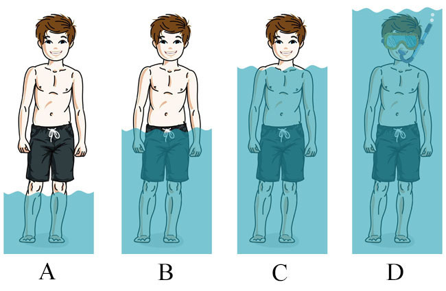
Just below a small cascade near the western side of the creek is a pothole a couple of metres across:
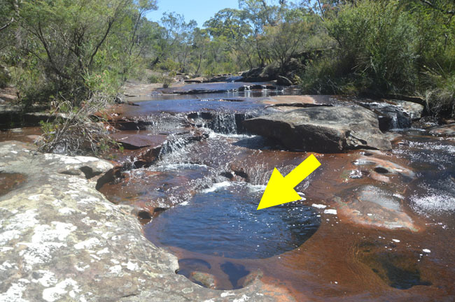
To answer this waypoint question, you can get in the hole if you want, or you can just use a long stick.
Question 1: If you were to stand in it (assuming there isn’t a drought and the pothole is full), how far up would the water come on you?
Once you’re ready to move on, proceed a little further downstream to trailhead T2 where the track picks up again, heading west away from the water through a gap between two large rocks.
Reference Point 1: The Cave
Here you'll come to a good sized cave which might well have been used as shelter by the local Aboriginal people. It’s the sort of place someone like me might hide a cache except, well the NPWS won’t let me.
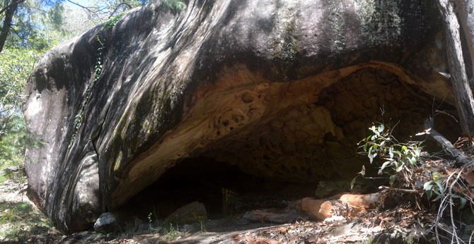
There’s no question to answer here but feel free to post whatever photos you like. The track continues around to the left of the cave.
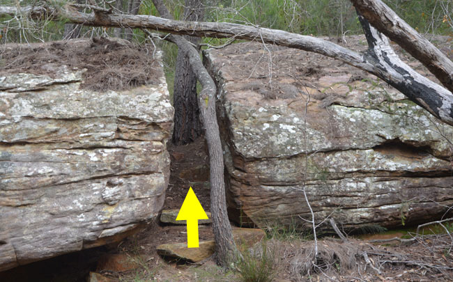
Reference Point 2: The Chute
Here you’ll come to a crevice in the rock that provides access to the upper level.
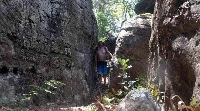
Make your way along to the northern end where there’s an easy climb up at the base of a tree.
Again there’s no question to answer here, so just enjoy the moment and take some photos.
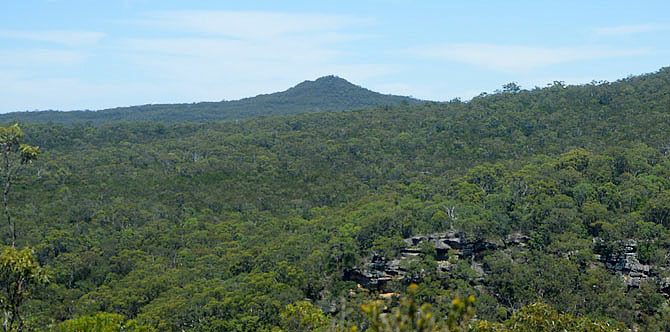
Reference Point 3: Mount Wondabyne View
From here you can look west to Mount Wondabyne, that distinctive conical-shaped peak everyone notices when travelling south along the M1 towards the Kariong Interchange. From this angle, though, it’s not very conical but more an elongated ridge with a high point at its northern end.
WP2: Waterfall Bay Overlook
After a long steady climb, the track emerges onto a rock shelf offering good views down across Waterfall Bay. From here you can even catch a glimpse of the top waterfall back near WP1.
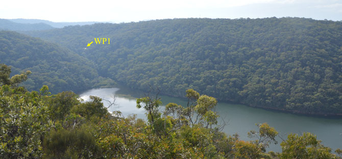
This is a good spot to pause for some refreshment and take a few photos, but first you have a question to answer.
Question 2: Looking east across the water to the ridge, what type of prominent man-made structure is on the top above the cliffs?
You only have a few hundred metres to go now before you reach GZ.
GZ: Spion Kop
You’ve arrived! Before getting too carried away with the views or the dragon-head rock, there’s one more question to answer and a photo to take, just to prove you were really here.
Question 3: On a Christmas long ago, someone named Abrams visited here and left their mark on the rock shelf. What year was it?
Photo Task: For this, you'll need to take a photo of yourself (face optional) or something identifiable as yours (your caching gear, a page with your caching name on it, etc.) with the dragon-head rock finger in the background.
THERE IS NO NEED TO CLIMB OUT ONTO THE FINGER!
In fact, I'd rather you didn't, at least for your log photos, so please don't tempt the ultimate DNF. This exposed location can get sudden and unexpected wind gusts, even on a calm day. Here's an example of where you can safely stand or sit:
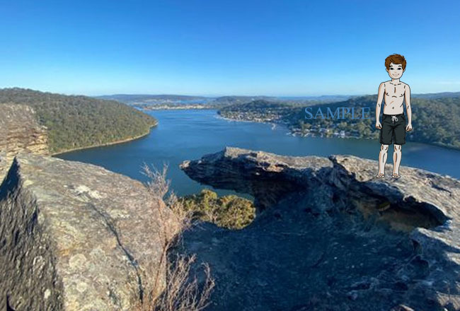
As this cache didn’t exist prior to publication, photos from earlier visits cannot be used to fulfil this requirement, nor can edited photos such as the one above.
So that’s it, mission accomplished! I hope you enjoy the location and the walk back. Email or message me your answers to the THREE questions and don’t forget to include your photo at GZ (along with any others you want to share) with your online log. I’ll endeavour to reply to all answers as soon as I can but there’s no need to wait, you can log your find as soon as you’ve sent them.
Congratulations to bella at waggy, asbestiform and crash2079, the first to kop it!
Virtual Rewards 4.0 - 2024-2025
This Virtual Cache is part of a limited release of Virtuals created between January 17, 2024 and January 17, 2025. Only 4,000 cache owners were given the opportunity to hide a Virtual Cache. Learn more about Virtual Rewards 4.0 on the Geocaching Blog.