
Cette cache n'est pas
accessible à marée haute
This cache is not accessible at high tide
Les falaises de Kerlaz (départ du Ris) sont un magnifique
endroit à découvrir... à
marée basse.
Selon mon estimation, en marée normale, vous avez une
fenêtre de +/-1h30 autour de l'horaire de la marée
basse.
Ne sous-estimez pas la marée, il n'y a pas
d'échappatoire à flanc de falaise.
Pour cela je vous invite à commencer la série par
la cache #1 la plus éloignée, en mer descendante.
The Ris cliffs are a
magnificent place to discover... at low tide.
In my estimation, during
normal tide, you have a window of +/-2 hours around the low tide time.
Don't underestimate the
tide, there is no escape from the cliff side.
To do this, I invite you
to start the series with cache #1, the furthest away, when the sea goes
down.
Horaires
de marées / Tide
times: www.horaire-maree.fr/maree/DOUARNENEZ/

click
on the flag to reach the translation
Une
Earthcache
Il ne s’agit pas d’une cache
physique. Pour loguer cette cache, vous devez dans un premier temps
prendre connaissance de
sa description éducative en
matière de géologie, puis d’observer le
site sur lequel vous êtes, et enfin de répondre
aux questions qui vous seront posées. Une
cotation
plus élevée de la difficulté
de l'earthcache nécessitera des réponses plus
avancées afin que votre log puisse être
validé.
Vous pourrez alors loguer en "Found it" sans attendre mais vous devez
me faire
parvenir vos réponses en même temps
en me
contactant soit par mail dans mon profil, soit via la messagerie
geocaching.com (Message Center), et je vous contacterai en cas de
problème. Les réponses collectives sont
acceptées à condition que les photos restent
individuelles et que soient mentionnés dans le log les
autres membres de la team.
Les logs 'found it' enregistrés sans
réponses ou sans photo ou trop rudimentaires seront
supprimés; vous pouvez toutefois les loguer en 'write note'
le temps de compléter tout ça
ultérieurement.

La
géologie du site

Le substrat est constitué
de schistes briovériens affectés par
le métamorphisme à l’approche du massif
granitique de Locronan (développement d’une
foliation parallèle au litage).
En
pied de falaise, un platier ancien est fossilisé par un
poudingue ferrugineux englobant
des galets de lithologie variée, montrant quelques
éléments de taille importante,
comme les quartz, issus vraisemblablement de lentilles ou de veines de
ségrégation
de quartz et de filons présents dans les formations
briovériennes. Cette formation
correspondant à un milieu à forte
énergie est coiffée par une formation
gréseuse
admettant des galets bien émoussés, puis par des
grès roux correspondant à des sables
dont la granulométrie est voisine de celle des sables
actuels de la plage de Trezmalaouen.
Ces
formations sont également présentes au fond
des cavités et des grottes échancrant la falaise
rocheuse. Des grès ferrugineux,
plaqués à la falaise rocheuse
jusqu’à 5 à 8 m au-dessus du niveau des
hautes mers
et englobant quelques éclats anguleux de schiste, correspondent à
une dune fossile, également
grésifiée par les eaux chargées
d’oxydes drainant le versant littoral.
Cette dune rousse, vraisemblablement contemporaine
du début d’un retrait de la mer, lorsque de vastes
estrans sableux se sont trouvés
soumis à la déflation éolienne,
à la fin de la transgression éémienne,
a été rapidement
imprégnée par la limonite, qui l'a
préservée, lorsque les coulées de
gélifluxion
ont par la suite raboté l’abrupt littoral durant
le Weichselien.
Les
spécialistes qui se sont succédé sur
le site ont observé que la dalle ferrugineuse
présentait un réseau de fissures avec des
décalages s’apparentant à la
réactivation
de fractures du substratum schisteux. Des réajustements
tectoniques sont en effet
possibles en raison de la proximité de l’accident
Kerforne, qui débouche dans l’anse
du Ry, à proximité.
Source: SGMB
Pour
aller plus loin en géologie
Crédits:
Fafahakkai
◊ Le grès
Le grès est une roche sédimentaire
détritique, issue de l’agrégation de
grains de taille majoritairement sableuse (0,06 mm à 2 mm)
et consolidé lors de la cimentation (appelée
diagénèse). Les grains constituant le
grès sont issus de l'érosion de roches
préexistantes qui déterminent en grande partie sa
composition, principalement constitué de quartz et
feldspath. Selon le degré de cimentation et sa composition,
il peut s'agir d'une roche très friable à
cohérente. On trouve une grande
variété de milieux où ce sont
déposés des grès, depuis le domaine
continental (rivière, plage) au domaine marin (turbidites).
Son équivalent non consolidé est
généralement appelé sable.
• Altération
Cette roche détritique peut subir différents
types d'altération aux contacts des
éléments atmosphériques.
Une des formes particulière de dégradation du
grès et d'autres roches non calcaires est la formation de
creux à surface lisse présentant une forme de
creux (rond ou oblongue), des cupules.
D'autres altération colorent la roche.
- Encrassement gypseux : des croûtes noires
épaisses et granuleuses se forment par réaction
du dioxyde de soufre contenu dans l’air avec les particules
de calcium présentes dans le grès. Elle se
forment généralement dans des endroits
à l'abri de la pluie
- Patine vernissée : De fines pellicules
également noires plus lisses se forment sur de larges pans
de la roche soumise aux lessivages de la pluie. Cette patine ne
détruit pas la roche comme le gypse, mais y
adhère fortement, formant une couche protectrice mais peu
esthétique. Cette patine est due à l'eau de pluie
qui pénètrent dans la pierre et
réagissent avec les minéraux contenant du fer.
Les ions ferreux peuvent migrer vers la surface où ils
précipitent sous cette forme de croûte fine noire
et patinée.
- Cristallisation et altération par les sels de la roche,
sous une forme de couche blanchâtre.
◊ Le schiste
Un schiste est une roche qui a pour particularité d'avoir un
aspect feuilleté, et de se débiter en plaques
fines ou « feuillet rocheux ». On dit qu'elle
présente une schistosité. Elle se
caractérise par un grain très fin, invisible
à l’œil nu ce qui fait qu'on dit qu'il
s'agit d'une roche non grenue, à l'aspect lisse au toucher.
• Le micaschiste
Un micaschiste est une roche métamorphique à
forte transformation constituée principalement de
minéraux en feuillets, ou phyllosilicates tels que des micas
et de la chlorite.
Comme les schistes moins métamorphiques, les micaschistes
sont caractérisés par un feuilletage
(schistosité ou foliation selon le degré de
métamorphisme) très marqué
résultant des déformations ductiles de la roche.
C'est une roche à texture très fine avec des
grains invisibles à l'oeil nu.
• Altération
Les micas sont soumis aux processus généraux
d'altération qui conduisent, à partir des
minéraux primaires silicatés, à la
formation de constituants secondaires. Ces minéraux
conservent la même structure en feuillets que dans les micas.
On retrouve ainsi :
- la vermiculitisation : en présence de solutions riches en
cations, le potassium inter-foliaire est remplacé par des
cations plus hydratables (Ca, Mg...) lors de hydratation.
Cela donne des minéraux blancs avec un teint mat, de la
vermiculite. Avec une transformation plus importante de la structure,
on peut obtenir un minéral argileux gonflant, la
montmorillonite.

- la chloritisation : la chloritisation s'effectue en milieu acide. Le
potassium est remplacé par de l'aluminium.
Cela donne un minéral vert donnant une coloration globale
verte à la roche, la chlorite.

- la rubéfaction : mis à l'air libre, le fer
contenu dans les minéraux va s'oxyder pour donner un oxyde
ferrrique (Fe2O3), de l'hématite.
Ce minéral prend une couleur rouille
caractéristique. Le fer oxydé peut migrer et se
rassembler pour donner des croûtes ferrugineuses.

D'un point de vue de l'érosion, le micaschiste, fortement
lité, s’effrite assez facilement en
écailles sous une action mécanique.
Cela donne donc une forme d'altération en fines couches de
roche en dégradé.

Questions
La lecture attentive du descriptif de la cache,
ainsi qu'une observation des éléments de terrain
et un peu de déduction sont normalement suffisants pour
répondre aux questions de cette EarthCache.
Voir le chapitre "une
earthcache" pour les conditions de log.
Question
0 - Prenez une photo indivuelle de vous (pas de
photo collective), ou de votre objet
distinctif de géocacheur, ou de votre pseudo
écrit sur une feuille de papier ou dans votre
main... un
peu comme celle de la photo d'observation
et joignez-là à votre log ou à vos
réponses
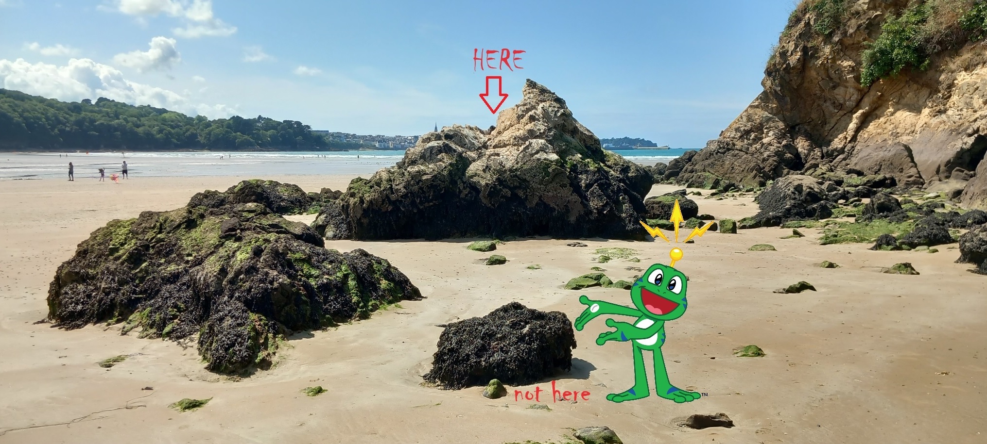
Tout d'abord, vous devez monter en haut du monticule de roche
indiqué sur la photo.
Question
1
- Au plus haut du rocher, plutôt côté
terre, décrivez la roche que vous voyez.
Nommez-là.
Question
2
- Au plus haut du plus haut, quelle altération chromatique
de la roche apercevez-vous ? Expliquez-la (couleur).
Question 3
- Autour de vous, toujours en haut mais quelques pieds
côté mer, quelle roche voyez-vous ? Sommes-nous
sur la même roche, si oui en quoi diffère-t-elle /
si non, nommez-là.
Question 4
- Quelle altération
chromatique de la roche apercevez-vous ? Expliquez-la (couleur).

An
Earthcache
This is not a
physical cache.
To log this cache, you must first
read its educational description of geology, then observe the site you
are on, and finally answer
the questions that will be asked. A higher earthcache difficulty rating
will require more advanced answers so your log can be validated.
You will then be able to log in "Found it" without waiting but you must
send me your
answers at the same time by contacting me either by email
in my profile, or via geocaching.com messaging (Message Center), and I
will contact you in case problem. Collective answers are accepted
provided that the photos remain individual and that the other members
of the team
are mentioned in the log.
'Found it' logs recorded without
answers or without
a photo or that are too rudimentary will be deleted; however, you can
log them in a 'write note' while you complete all of this later.
Geology
of the site
The substrate is made up of Brioverian schists
affected by metamorphism
approaching the granite massif of Locronan (development of foliation
parallel to the bedding).
At the foot of the cliff, an ancient reef flat (wave-cut plateform) is
fossilized by a
ferruginous pudding encompassing pebbles of varied lithology, showing
some large elements, such as quartz, probably coming from lenses or
veins of quartz segregation and veins present in the formations.
Brioverian. This formation corresponding to a high energy environment
is capped by a sandstone formation with very blunt pebbles, then by red
sandstones corresponding to sands whose grain size is close to that of
the current sands of the Trezmalaouen beach.
These formations are also present at the bottom of cavities and caves
indenting the rocky cliff. Ferruginous sandstones, clad on the rocky
cliff up to 5 to 8 m above high sea level and including a few angular
shards of shale, correspond to a fossil dune, also sandified by the
oxide-laden waters draining the slope littoral. This red dune, probably
contemporary with the beginning of a retreat of the sea, when vast
sandy foreshores found themselves subject to wind deflation, at the end
of the Eemian transgression, was quickly impregnated by limonite, which
preserved, when the gelifluxion flows subsequently planed the steep
coastline during the Weichselien.
The specialists who successively visited the site observed that the
ferruginous slab presented a network of cracks with offsets resembling
the reactivation of fractures in the shale bedrock. Tectonic
readjustments are in fact possible due to the proximity of the Kerforne
accident, which opens into the nearby Ry cove.
Source: SGMB
To
go further in geology
◊ Sandstone
Sandstone is a detrital sedimentary rock, resulting from the
aggregation of grains of predominantly sandy size (0.06 mm to 2 mm) and
consolidated during cementation (called diagenesis). The grains
constituting the sandstone come from the erosion of pre-existing rocks
which largely determine its composition, mainly consisting of quartz
and feldspar. Depending on the degree of cementation and its
composition, it can be a very friable to coherent rock. We find a wide
variety of environments where sandstones are deposited, from the
continental domain (river, beach) to the marine domain (turbidites).
Its unconsolidated equivalent is generally called sand.
• Alteration
This detrital rock can undergo different types of alteration in contact
with atmospheric elements.
One of the particular forms of degradation of sandstone and other
non-calcareous rocks is the formation of hollows with a smooth surface
having a hollow shape (round or oblong), cupules.
Other alterations color the rock.
- Gypsum fouling: thick, grainy black crusts are formed by the reaction
of sulfur dioxide contained in the air with calcium particles present
in the sandstone. They generally form in places sheltered from rain
- Glazed patina: Fine films, also black and smoother, form on large
sections of the rock subjected to washing by rain. This patina does not
destroy the rock like gypsum, but adheres strongly to it, forming a
protective but unattractive layer. This patina is due to rainwater
penetrating the stone and reacting with iron-containing minerals.
Ferrous ions can migrate to the surface where they precipitate in this
form of a thin black and weathered crust.
- Crystallization and alteration by rock salts, in the form of a
whitish layer.
◊ Schist
A schist is a rock which has the particularity of having a laminated
appearance, and of being cut into thin plates or “rock
sheets”. It is said to have schistosity. It is characterized
by a very fine grain, invisible to the naked eye, which means that it
is said to be a non-grained rock, with a smooth appearance to the touch.
• Micaschist
A mica schist is a highly transformed metamorphic rock consisting
mainly of sheet minerals, or phyllosilicates such as micas and chlorite.
Like less metamorphic schists, mica schists are characterized by very
marked foliation (schistosity or foliation depending on the degree of
metamorphism) resulting from ductile deformations of the rock.
It is a very fine textured rock with grains invisible to the naked eye.
• Alteration
Micas are subject to general alteration processes which lead, from
primary silicate minerals, to the formation of secondary constituents.
These minerals maintain the same layered structure as in micas.
We thus find:
- vermiculitization: in the presence of solutions rich in cations, the
inter-foliar potassium is replaced by more hydratable cations (Ca, Mg,
etc.) during hydration.
This gives white minerals with a dull complexion, vermiculite. With
further transformation of the structure, a swelling clay mineral,
montmorillonite, can be obtained.
- chloritization: chloritization takes place in an acidic environment.
Potassium is replaced by aluminum.
This produces a green mineral giving an overall green color to the
rock, chlorite.
- reddening: exposed to the open air, the iron contained in the
minerals will oxidize to give ferric oxide (Fe2O3), hematite.
This mineral takes on a characteristic rust color. Oxidized iron can
migrate and collect to form ferruginous crusts.
From an erosion point of view, the mica schist, strongly layered,
crumbles quite easily into scales under mechanical action.
This therefore gives a form of alteration in thin layers of degraded
rock.
Questions
Careful reading of the description
of the cache, as
well as an observation of the terrain features and a little deduction
are normally sufficient to answer the questions of this
EarthCache.
See
chapter "an
earthcache" for log conditions.
Question
0 - Take an individual photo of yourself (no
collective photo), or your distinctive geocacher object, or your
nickname written on a sheet of paper or in your hand... a bit like the one in the
observation photo,
and
attach it to your log or your answers
First, you need to climb to the top of the
rock mound shown in the photo.
Question
1
- At the highest point of
the rock, on the landward side, describe the rock you see. Name it.
Question
2
- At the highest of the highest, what chromatic alteration of the rock
do you see? Explain it (color).
Question 3
- Around you, still at the top but a few feet towards the sea, what
rock do you see? Are we on the same rock, if so how does it differ / if
not, name it.
Question 4
- What chromatic
alteration of the rock do you see? Explain it (color).