Chaos rocheux au Tanet ...
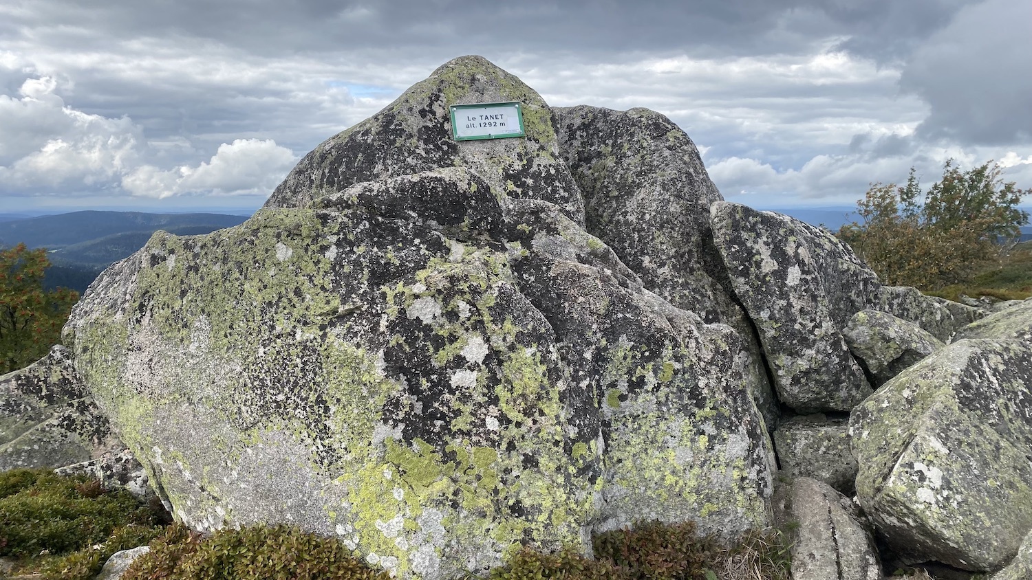
Le Tanet est une montagne de la crête vosgienne culminant à 1 292 m. Elle a donné son nom à une station de ski accrochée à son flanc alsacien.
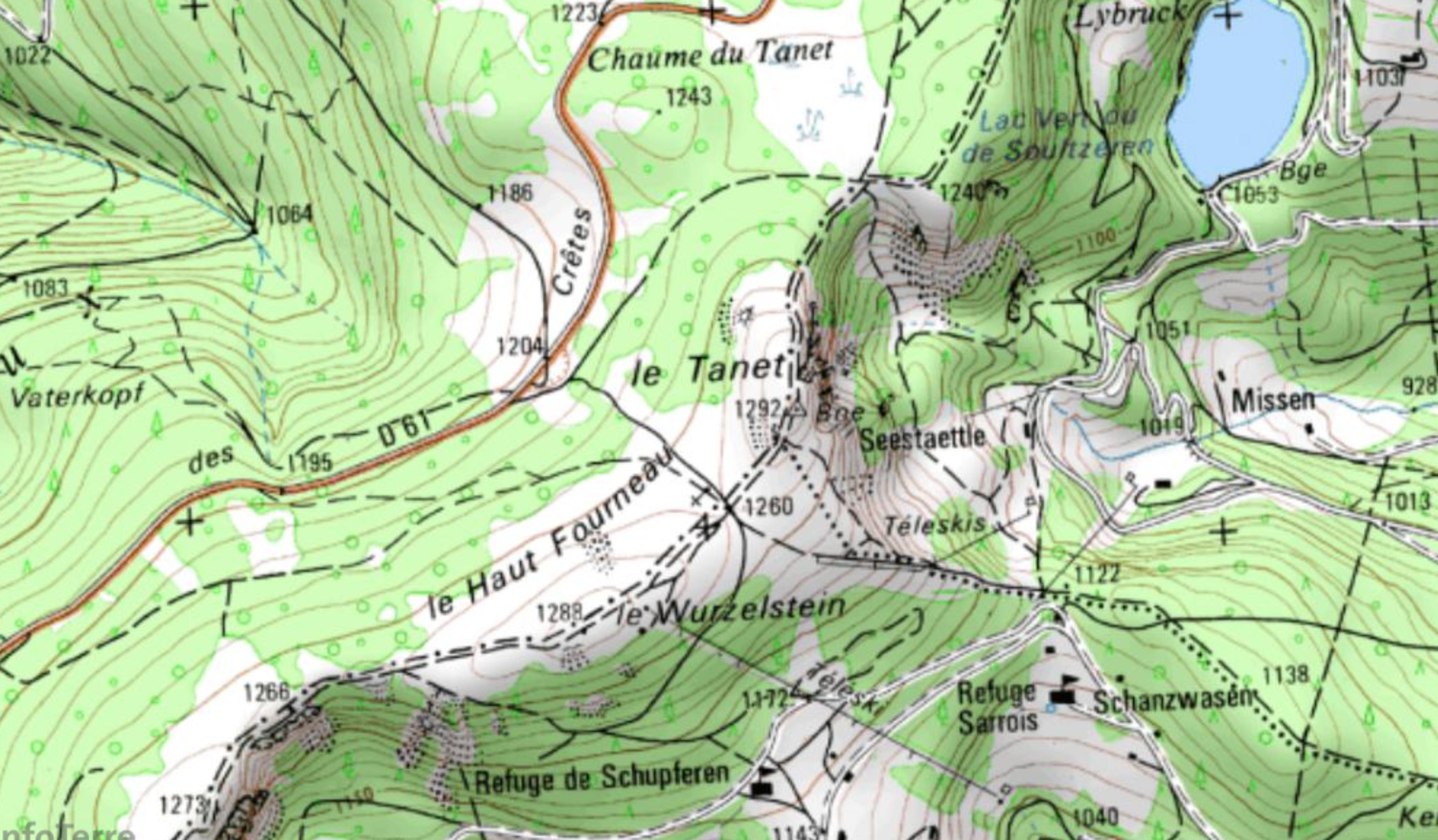
Le Tanet surplombe la combe du Valtin sur le versant lorrain, et les forêts et anciens pâturages du lac Vert et de la vallée d'Altenbach sur le versant alsacien. Ces deux vallées ouvertes vers l'orient sont formées d'anciens cirques glaciaires profondément creusés et ciselés, notamment ceux du lac Vert et du Seestaettlein. Le Tanet est situé entre le Gazon de Faîte et le Monthabeu.
Son sommet au nord du Haut Fourneau culmine à 1 292 mètres d'altitude. Il est recouvert de blocs rocheux, aussi les nomme-t-on communément les rochers du Tanet. Leur dénomination correspondante en alsacien ou allemand est Taneckfelsen. Le sommet est accessible par le sentier de grande randonnée GR5.
Ce surprenant amas rocheux est composé de bloc de granite du Lac Vert (granitoïde péralumineux) âgé de 330 millions d’année, avec une mise en place liée à l’orogenèse Varisque lors de la formation de la Pangée.
Ce sommet présente un relief dissymétrique. Le versant vosgien, en pente douce est un témoin du soulèvement du socle hercynien à l’ère tertiaire exhumé lors du rehaussement du socle vosgien à l’époque alpine. Le versant alsacien, plus abrupt, est échancré́ par plusieurs cirques glaciaires datant du Quaternaire. Les lignes de niveau sur la carte IGN du secteur montrent bien la rupture de pente à l'Est vers l'Alsace et la pente plus douce de la chaume vers la vallée du Valtin avant de descendre vers le fond de cette ancienne vallée glaciaire.
Les roches rencontrées sur la crête datent de l'époque du Carbonifère (- 330 Ma), voir la carte du BRGM
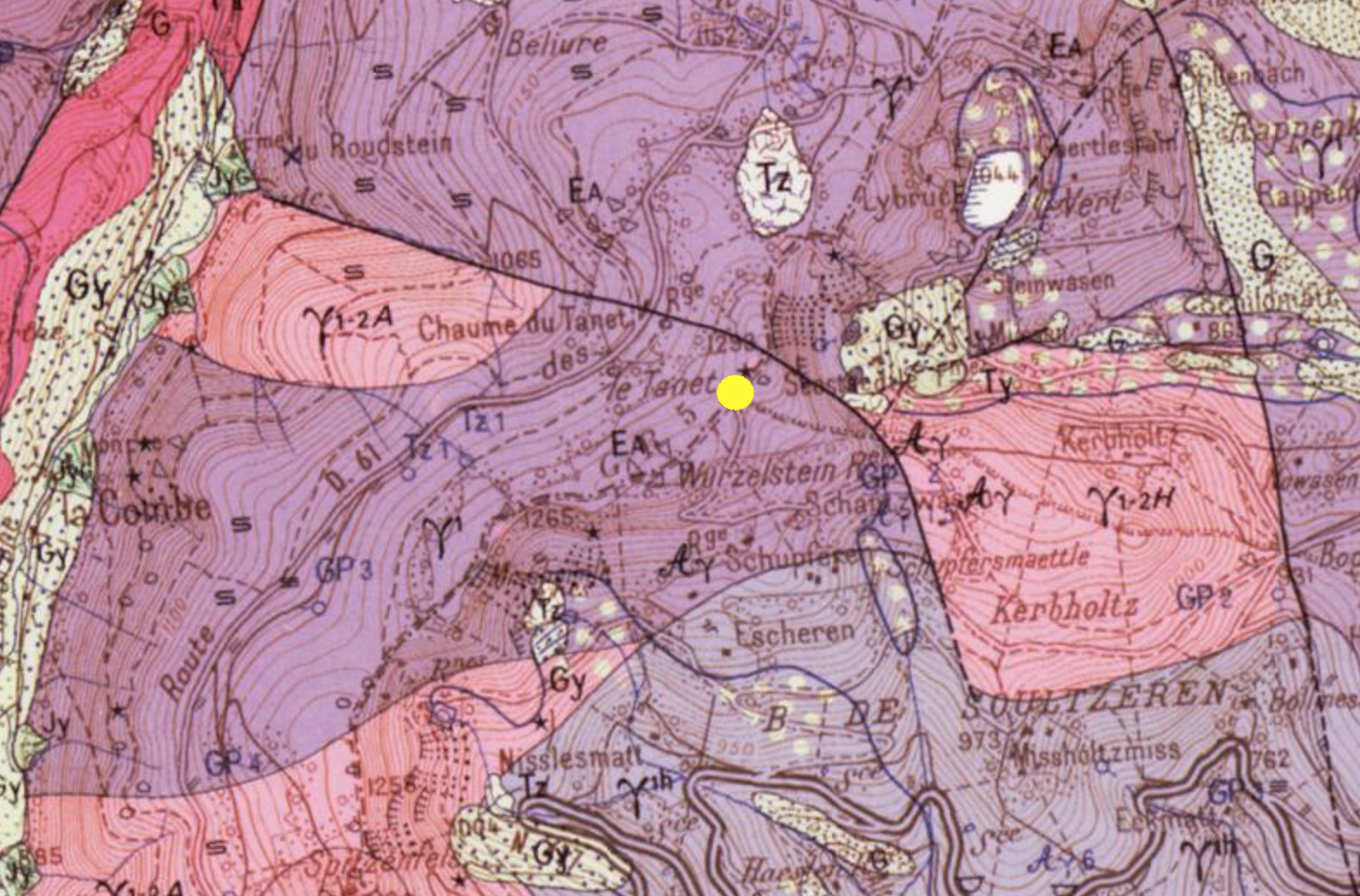
Notice du BRGM concernant ce granite
Sa composition minéralogique est exprimée par une analyse modale volumique (pourcentages) :
|
Quartz
|
Microcline
|
Plagioclase
|
Biotite
|
Muscovite
|
Minéraux
accessoires
|
| 25 |
18 à 25 |
35 à 42 |
10 |
4 |
1 |
Le quartz se présente en cristaux groupés en amas, à structure engrenée. Le microcline est perthitique et poecilitique. La biotite est parfois disposée en structure cloisonnée et est plus ou moins transformée en chlorite. La muscovite a plusieurs habitus : cristaux libres et bien cristallisés, cristaux liés par épitaxie aux plagioclases, nids de pinite occupant la place de fantômes de cordiérite. Les principaux minéraux accessoires sont le sphène, le zircon et l'apatite. Le granite du lac Vert contient quelques enclaves surmicacées. C'est un granite leucocrate, subalcalin et fortement sodique.
Nom scientifique de ce chaos rocheux
La position de ces blocs apparement empilés en chaos est en réalité un « Tor » : une formation où les blocs ont été séparé par l’action de l’eau, du gel et du vent sur les diaclases (fracturation préexistante).
Remerciements
Merci au Conservateur du Centre de Géologie TERRAE GENESIS (28 rue de la Gare - Peccavillers - 88120 LE SYNDICAT) pour les précisions apportées pour le descriptif de cette EarthCache
Les diverses questions
Question 1 : sur le sentier, encombré de nombreuses roches granitiques, en N 48° 04.939' E 007° 03.0672', vous trouverez cette roche au sol :
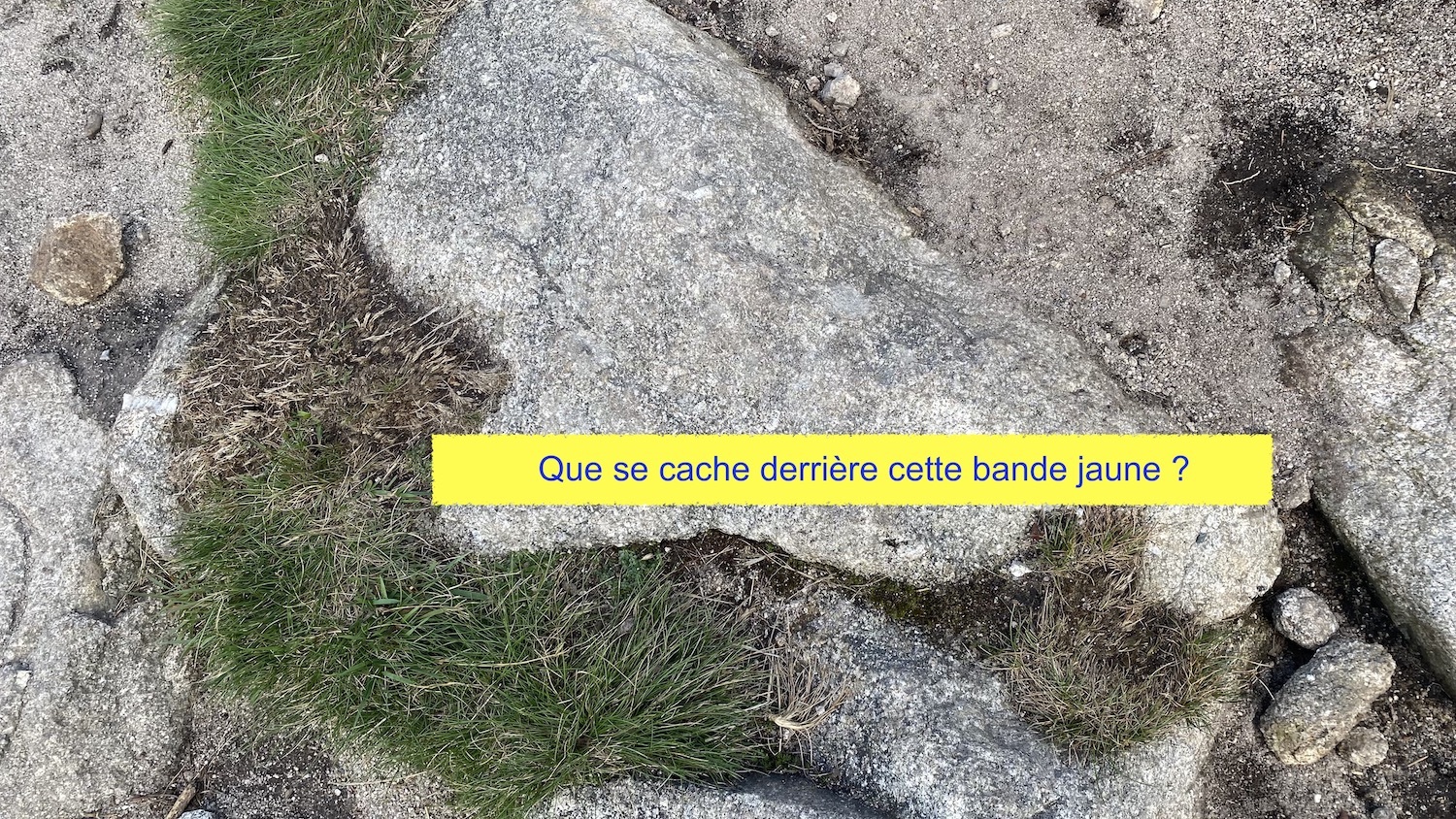
Que se cache derrière la bande jaune de la photo ?
Question 2 : quel type de granite rencontrez-vous ici et de quelle époque ?
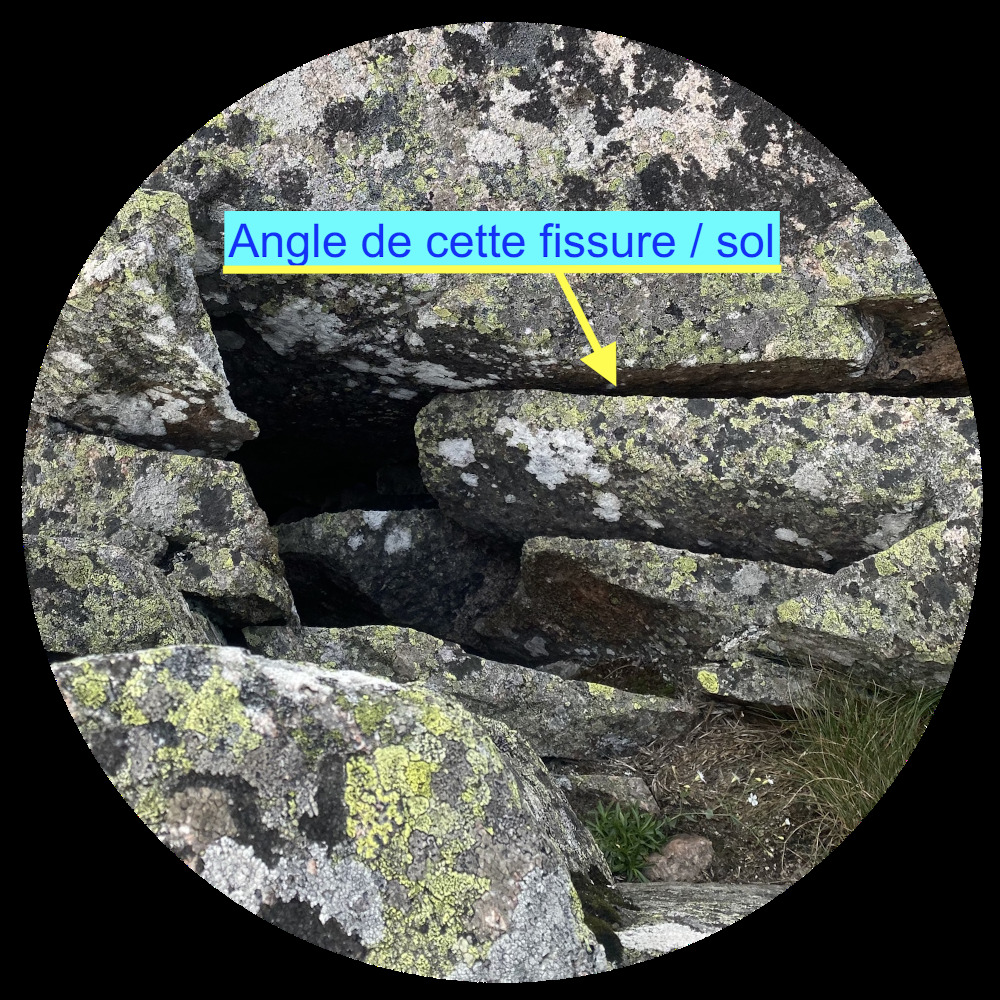
Question 3 : proche du sommet du Tanet vous trouverez ce bloc fissuré (voir photo - attention la fissure n'est pas horizontale), quel angle forme la fissure par rapport au sol ?
Question 4 : Avec vos mots, décrivez la forme des blocs au sommet du Tanet (lisses, rugueux, anguleux, arrondis, empilés régulièrment ou non ...) et expliquez quels phénomènes géologiques en est l'origine.
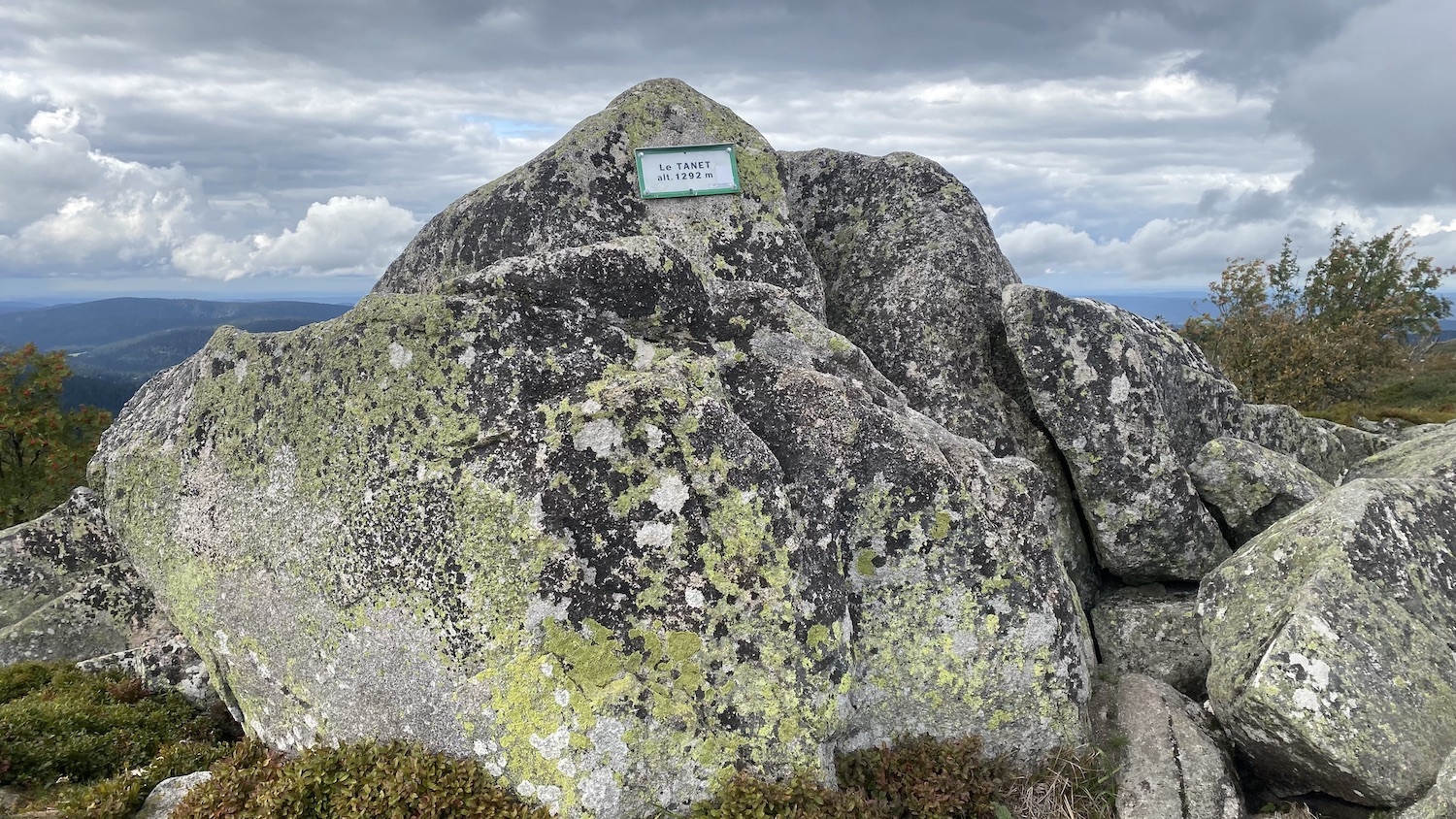
Une photo avec votre pseudo visible sur une morceau de papier ou autres, ou de vous avec le panneau "Le TANET alt 1292m" en arrière-plan doit être jointe au log.
Comment loguer :
Loguez cette cache "Found it" et envoyez-moi vos propositions de réponses soit via mon profil, soit via la messagerie geocaching.com (Message Center), et je vous contacterai en cas de problème.
A découvrir sur le sentier et sans rapport avec la géologie :
En N 48° 04.905' E 007° 03.020', au croisement des sentiers, n'hésitez pas à découvrir le panneau sur l'histoire des chiens de traîneaux venus du Canada pendant la Guerre de 14-18.
A découvrir au sommet :
En N 48° 05.019' E 007° 03.129', en N 48° 05.019' E 007° 03.129', vous pouvez découvrir un ancien repère géologique.

Profitez bien du panorama ...
Rocky chaos at Tanet ...
Le Tanet is a mountain on the Vosges ridge, rising to 1,292m. It has given its name to a ski resort clinging to its Alsatian flank.
Le Tanet overlooks the Valtin combe on the Lorraine side, and the forests and ancient pastures of Lac Vert and the Altenbach valley on the Alsace side. These two east-facing valleys are formed by ancient glacial cirques, deeply carved and sculpted, notably those of Lac Vert and Seestaettlein. Le Tanet lies between Gazon de Faîte and Monthabeu.
Its summit to the north of the Haut Fourneau rises to an altitude of 1,292 metres. It is covered with boulders, which are commonly referred to as the Tanet rocks. The corresponding name in Alsatian or German is Taneckfelsen. The summit is accessible via the GR5 long-distance hiking trail.
This astonishing cluster of rocks is made up of 330 million-year-old Lac Vert granite blocks (peraluminous granitoids), whose emplacement is linked to the Variscan orogeny during the formation of Pangea.
The summit's relief is asymmetrical. The gently sloping Vosges side bears witness to the uplift of the Hercynian basement in the Tertiary era, which was exhumed when the Vosges basement was raised in the Alpine period. The steeper Alsatian side is indented́ by several glacial cirques dating from the Quaternary period. The level lines on the IGN map of the area clearly show the break in slope to the east towards Alsace and the gentler slope of the stubble towards the Valtin valley before descending to the bottom of this former glacial valley.
The rocks found on the ridge date from the Carboniferous period (- 330 Ma), see the BRGM map.

BRGM's notice on this granite
Its mineralogical composition is expressed by volume modal analysis (percentages)
|
Quartz
|
Microcline
|
Plagioclase
|
Biotite
|
Muscovite
|
Minéraux
accessoires
|
| 25 |
18 à 25 |
35 à 42 |
10 |
4 |
1 |
Quartz occurs in crystals grouped in clusters, with an interlocking structure. Microcline is perthitic and poecilitic. Biotite is sometimes arranged in a partitioned structure and is more or less transformed into chlorite. Muscovite has several habitus: free, well-crystallized crystals, crystals epitaxially bonded to plagioclase, pinite nests occupying the place of cordierite ghosts. The main accessory minerals are sphene, zircon and apatite. Lac Vert granite contains a few overmicaceous enclaves. It is a leucocratic, subalkaline and strongly sodic granite.
Scientific name for this rocky chaos
The position of these apparently chaotically stacked blocks is actually a "Tor": a formation where the blocks have been separated by the action of water, frost and wind on the diaclases (pre-existing fracturing).
Many thanks
Thanks to the Conservator of the Centre de Géologie TERRAE GENESIS (28 rue de la Gare - Peccavillers - 88120 LE SYNDICAT) for the details provided for the description of this EarthCache.
Various questions
Question 1 : On the trail, cluttered with numerous granite rocks, at N 48° 04.939' E 007° 03.0672', you'll find this rock on the ground:
What's behind the yellow stripe in the photo ?
Question 2 : What type of granite do you find here, and from what period ?
Question 3 : Near the summit of Tanet you'll find this cracked boulder (see photo - note that the crack is not horizontal). What angle does the crack form in relation to the ground?
Question 4 : In your own words, describe the shape of the boulders at the summit of Tanet (smooth, rough, angular, rounded, regularly or irregularly stacked ...) and explain the geological phenomena behind them.
A photo with your nickname visible on a piece of paper or similar, or of you with the sign "Le TANET alt 1292m" in the background, must be attached to the log.
How to log :
Log this "Found it" cache and send me your suggested answers either via my profile, or via the geocaching.com messaging system (Message Center), and I'll contact you if there's a problem.
To be discovered on the trail and unrelated to geology :
In N 48° 04.905' E 007° 03.020', at the trail junction, don't hesitate to discover the panel on the history of the sled dogs that came from Canada during the 14-18 War.
Discover the summit :
At N 48° 05.019' E 007° 03.129', at N 48° 05.019' E 007° 03.129', you can discover an ancient geological landmark.
Enjoy the panorama ...