Les Claires Eaux du Plan des Lacs EarthCache
Les Claires Eaux du Plan des Lacs
-
Difficulty:
-

-
Terrain:
-

Size:  (other)
Please note Use of geocaching.com services is subject to the terms and conditions
in our disclaimer.
FRANÇAIS
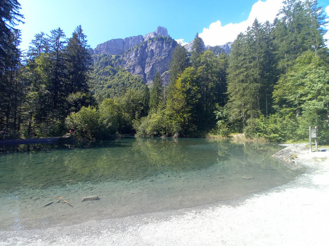
Au débouché du Cirque du Fer à Cheval, le Plan des Lacs forme une étendue relativement plane encadrée par le Giffre et son affluent, le Nant des Joathons. On y trouve un petit lac aux eaux particulièrement transparentes.
Les sommets qui entourent le Cirque du Fer à Cheval, et particulièrement le chainon Ruan-Tenneverge situé à l’est, sont de véritables châteaux d’eau. Ils sont constitués de calcaires fortement plissés et fissurés.
Ces roches perméables absorbent progressivement les eaux issues des fortes précipitations, essentiellement neigeuses, et de la fonte des glaciers du Ruan et de Prazon.
Les eaux s’infiltrent par gravité à travers les différentes couches avant de rencontrer au niveau du Plan des Lacs une couche de marnes imperméables.
Les eaux filtrées et transparentes s’écoulent alors vers le lac.
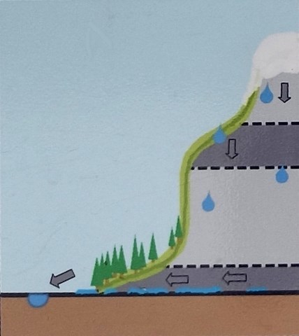
Coupe géologue simplifiée
Comme pour toutes les earthcaches, l’objectif n’est pas de découvrir une boîte. Pour valider votre visite, il vous suffit de vous rendre au point de référence indiqué. Vos observations ainsi que le descriptif ci-dessus vous permettront de valider cette earthcache en répondant aux questions suivantes :
1 - Le calcaire est-il une roche perméable ou imperméable ?
2 - Sur la coupe géologique simplifiée, quelle couleur représente la couche de marnes ?
3 - Au point de référence, mettez votre main dans l'eau. Est elle froide, tiède ou chaude ? Pour quelle raison d'après vous ?
4 - Prenez une photo du lac que vous joindrez obligatoirement à votre log.
Après avoir terminé vos observation, loguez cette earthcache "Found it" et envoyez-moi vos propositions de réponses soit via mon profil, soit via le Message Center. Je vous contacterai en cas de problème.
ENGLISH
At the mouth of the Cirque du Fer à Cheval, the Plan des Lacs forms a relatively flat expanse framed by the Giffre and its tributary, the Nant des Joathons. There is a small lake with particularly transparent waters.
The peaks that surround the Cirque du Fer à Cheval, and particularly the Ruan-Tenneverge range located to the east, are real water towers. They consist of strongly folded and fissured limestones. These permeable rocks gradually absorb water from heavy rainfall, mainly snow, and the melting of the Ruan and Prazon glaciers.
The water infiltrates by gravity through the different layers before encountering a layer of impermeable marl at the level of the Plan des Lacs.
The filtered and transparent waters then flow towards the lake.
Simplified geological section
As with all earthcaches, the objective is not to discover a box. To validate your visit, you just have to go to the indicated reference point. Your observations as well as the description above will allow you to validate this earthcache by answering the following questions:
1 - Is limestone a permeable or impermeable rock?
2 - On the simplified geological section, what color represents the marl layer?
3 - At the reference point, put your hand in the water. Is it cold, lukewarm or hot? Why do you think?
4 - Take a picture of the lake that you must attach to your log.
After having finished your observations, log this earthcache "Found it" and send me your proposals of answers either via my profile, or via the Message Center. I will contact you if there is a problem.
Additional Hints
(No hints available.)