(FR)
Baïne signifie « petite bassine » en gascon.
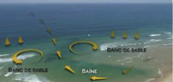
Géologiquement parlant, il s’agit d’une dépression topographique temporaire, ou mare résiduelle, qui n’est pas sans évoquer une piscine naturelle située sur la partie basse de la plage. Elle se forme dans la zone de déferlement des vagues. On les nomme parfois « sillons de plage ».
Cet aspect est particulièrement bon enfant et traitre, ce qui explique la quantité importante de noyades chaque année le long des littoraux où elles se forment volontiers.
À marée basse, une baïne ressemble à une cavité régulière, ce qui permet de déceler des zones à risque quelques heures plus tard. Attention, ceci est un descriptif de géocache et certainement pas une incitation à se baigner dans une zone à risque, bien au contraire.
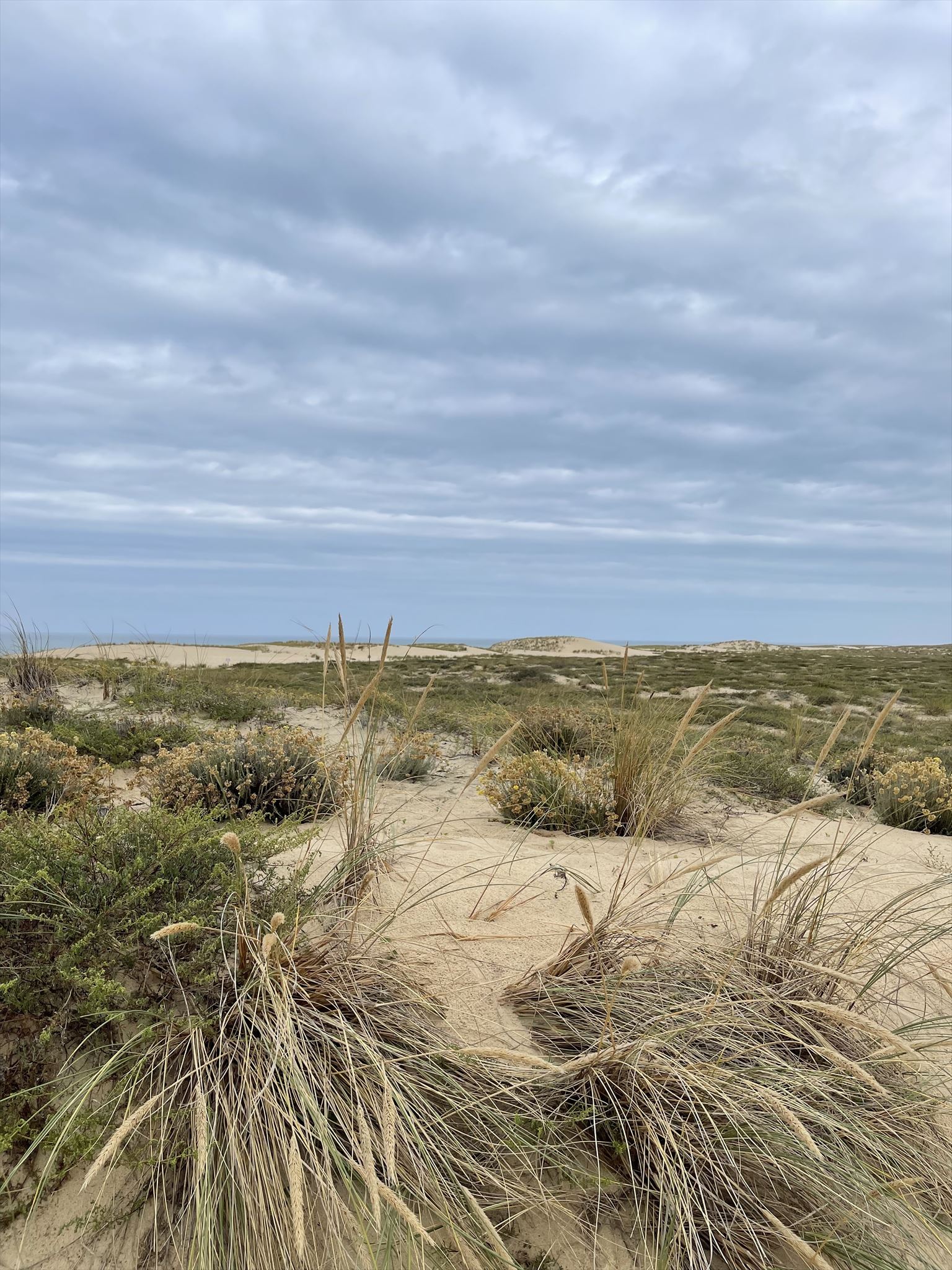
Cette formation géologique temporaire se retrouve sur la plupart des côtes du monde mais le terme baïne est en usage dans le sud-ouest de la France sur la côte Atlantique, comme ici sur la presqu’île du Cap-Ferret.
Sur les côtes de Bretagne ou de la Manche, on les nomme bâche.
Sur le plan géologique, les baïnes caractérisent les plages avec un marnage macrotidal, un gradient sédimentaire doux et un fetch assez court, induisant une morphologie barres-bâches parallèles ou subparallèles à la côte. Autrement dit, il s’agit d’une alternance de sillons avec des bancs de sable intertidaux appelés barres. Intertidal désigne ce qui est situé entre la marée basse et la marée haute, c'est-à-dire la bande qu'on appelle aussi l'estran.
Les baïnes se forment sur un relief où le phénomène de marée est fort.
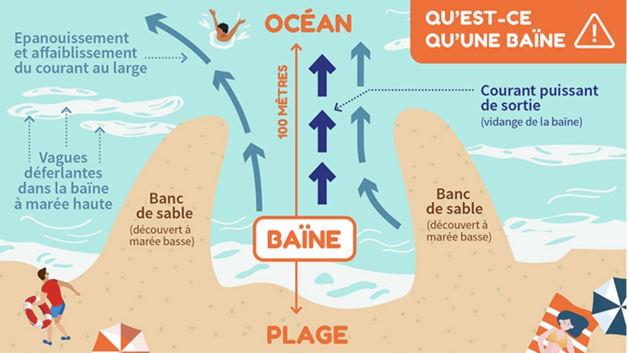
Il faut également que le sable soit fin, le dénivelé de la plage faible, et avec une forte houle. La houle déplace le sable le long du rivage, interférant avec les courants perpendiculaires à la plage. Ces courants emportent vers le large le sable de fond, creusant ainsi des cuvettes visibles à marée basse.
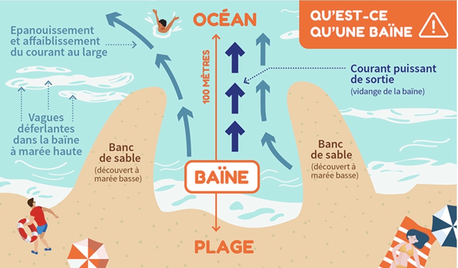
Celles-ci peuvent atteindre une centaine de mètres de large et cinq mètres de profondeur. Chaque baïne a une morphologie propre et engendre différentes formes de courants.
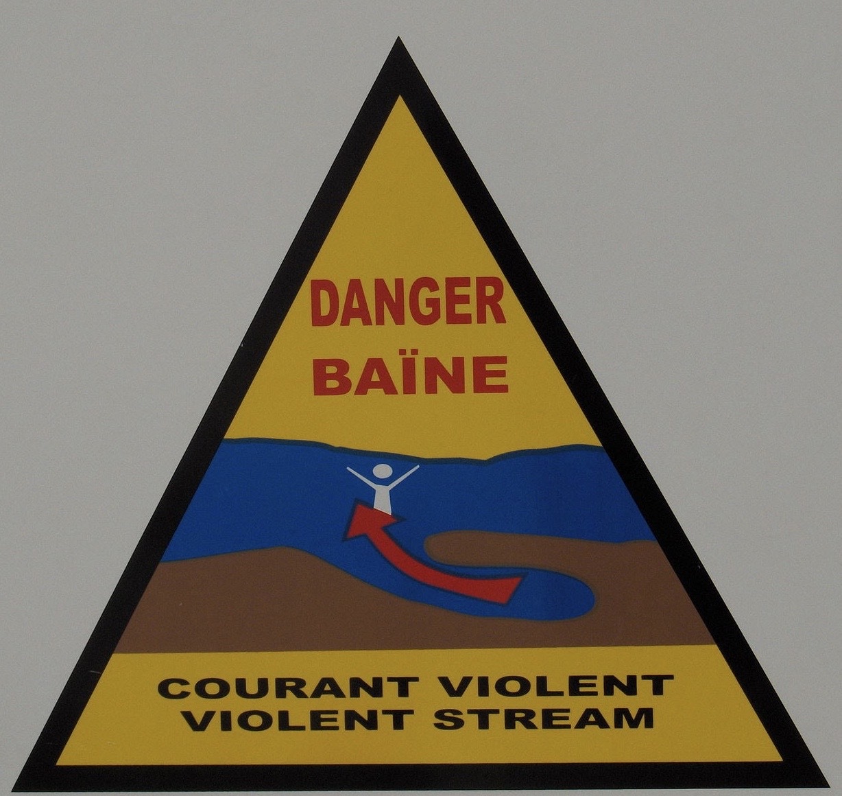
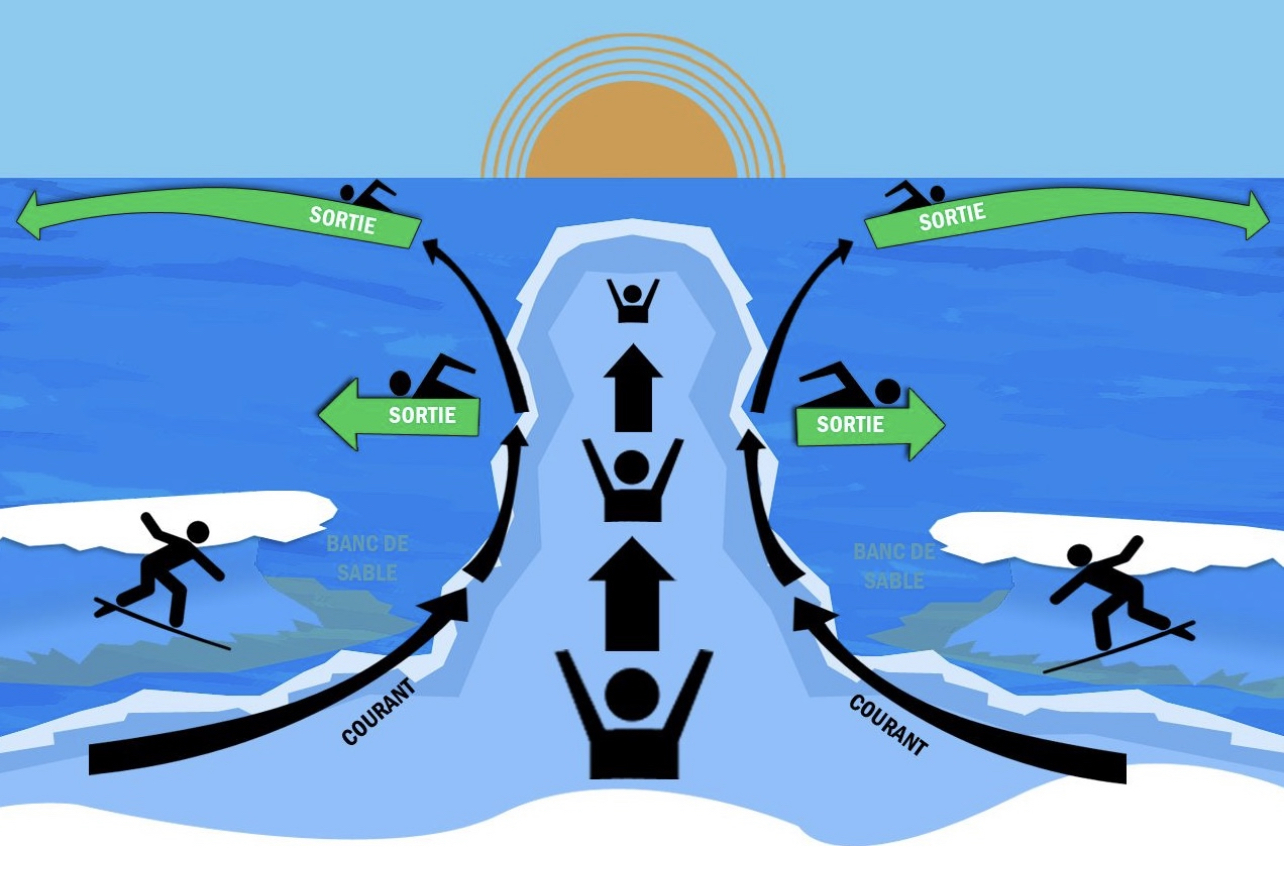
Lorsque la marée recouvre la baïne, l'eau s'échappe violemment vers l'aval selon un système de vidange. Ce sont ces courants de « sorties de baïnes », ou courant d'arrachement, qui provoquent chaque année des accidents parfois mortels.
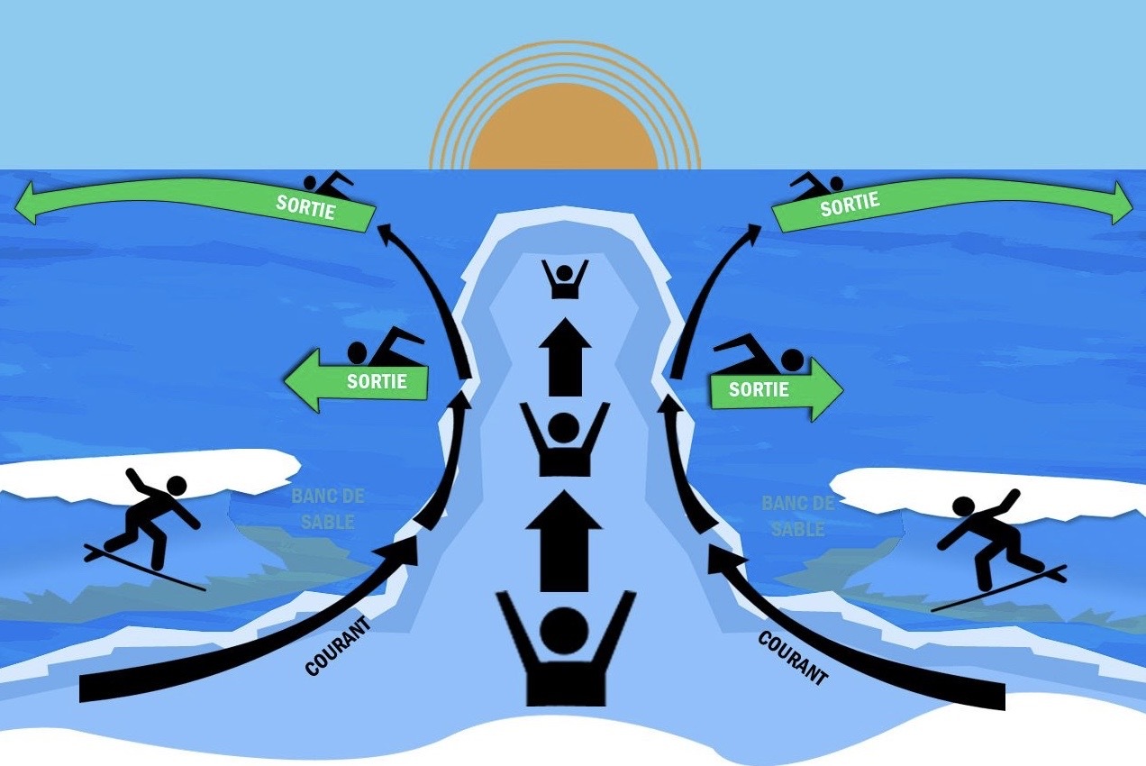
Le meilleur comportement à adopter reste alors de se laisser porter par le courant sans lui opposer de résistance et d'attirer l'attention des sauveteurs. On peut également tenter de rejoindre la plage en nageant latéralement, pour sortir du courant par les côtés. Il est inutile d'affronter le courant de face et de vouloir revenir à son point de départ sur la plage.
Le danger se manifeste durant la seconde et la troisième heure de la marée montante, quand les vagues passent par-dessus le banc de sable qui sépare en partie la baïne de la mer, ainsi qu’entre la quatrième et la sixième heure de la marée descendante.
Ces considérations sont des données scientifiques en lien avec l’information qu’on doit trouver dans le descriptif d’une Earthcache. Il n’y a aucun intérêt à faire des calculs savants selon l’heure des marées, ce serait même dangereux.
Il est déconseillé de se baigner dans les endroits de cette nature, ce ne sont pas les coins agréables pour les loisirs nautiques qui manquent dans le secteur.
Il y a quelques années, on voyait ici des panneaux mis en place par les CRS-Sauveteurs permettant de se souvenir du danger des baïnes, à partir d’un acrostiche facile à mémoriser :
Bassin d’eaux
Apparemment
Inoffensif à
Noyade
Eventuelle
Ces panneaux indicateurs ont été remplacés depuis par d’autres signes informant du grand danger des baïnes. Au PZ de cette cache se trouve un tableau régulièrement mis à jour par les sauveteurs pour informer les estivants.
Questions :
- Prenez une poignée de sable dans la main. Observez le comportement du sable si vous voulez le retenir dans votre poing fermé. Expliquez brièvement pourquoi la nature du sable ici est propice à la formation de baïnes.
- Regardez à présent la mer. L’observation de celle-ci explique que le lieu soit propice à la formation de baïnes. Pourquoi ?
- Il y a sur la plage plusieurs écoles. La pratique de ce qu’on y enseigne est souvent retrouvée dans les zones où se forment des baïnes. De quelle activité s’agit-il ?
Le propriétaire de la cache apprécierait grandement que vous joigniez une photo de la mer et de la plage prise aux alentours du PZ.
Loguez cette cache "Found it" et envoyez-moi vos propositions de réponses via mon profil ou bien via la messagerie geocaching.com (Message Center), et je vous contacterai en cas de problème.
Merci de mettre un point favori à cette cache afin de faciliter la consultation de son descriptif et peut-être sauver des vies.
Soyez prudents !
(EN)
Baïne means "small basin" in Gascon.
Geologically speaking, it is a temporary topographic depression, or residual pond, which is reminiscent of a natural swimming pool located on the lower part of the beach. It forms in the zone of breaking waves. They are sometimes called “beach furrows”.
This aspect is particularly good-natured and treacherous, which explains the large number of drownings each year along the coasts where they willingly form.
At low tide, a baïne resembles a regular cavity, which makes it possible to detect areas at risk a few hours later. Please note, this is a geocache description and certainly not an incentive to swim in a high-risk area, quite the contrary.
This temporary geological formation is found on most of the coasts of the world, but the term baïne is used in the south-west of France on the Atlantic coast where they are mainly seen on the neo-Aquitaine coast, as here on the peninsula of Cap-Ferret.
On the coasts of Brittany or the English Channel, they are called tarpaulin or “bache”.
Geologically, the baïnes characterize beaches with a macrotidal range, a gentle sedimentary gradient and a fairly short fetch, inducing a bar-tarpaulin morphology parallel or subparallel to the coast. In other words, it is an alternation of furrows with intertidal sandbanks called bars. Intertidal designates what is located between low tide and high tide, that is to say the band which is also called the foreshore.
The baïnes are formed on a relief where the tidal phenomenon is strong.
The sand must also be fine, the elevation of the beach low, and with a strong swell. The swell moves the sand along the shore, interfering with the currents perpendicular to the beach. These currents carry the bottom sand out to sea, thus digging basins visible at low tide.
These can reach a hundred meters wide and five meters deep. Each baïne has its own morphology and generates different forms of currents.
When the tide covers the baïne, the water escapes violently downstream according to a drainage system. It is these currents of "baïnes outlets", or rip currents, accompanied by the phenomenon of panic, which cause often fatal accidents every year.
The best behavior to adopt then remains to let yourself be carried by the current without putting up any resistance and to attract the attention of the rescuers. You can also try to reach the beach by swimming laterally, to get out of the current by the sides. There is no need to face the current head on and want to return to your starting point on the beach.
The danger manifests itself during the second and third hour of the rising tide, when the waves pass over the sandbank which partly separates the baïne from the sea, as well as between the fourth and sixth hour of the descending tide.
These considerations are scientific data related to the information that must be found in the description of an Earth cache. There is no point in making scholarly calculations according to the time of the tides, it would even be dangerous.
It is not recommended to bathe in places of this nature, it is not the pleasant corners for nautical leisures which are lacking in the sector.
A few years ago, we saw signs here put up by the CRS-Lifesavers to remember the danger of baïnes, from an easy-to-memorize acrostic with the French word BAINE. The translation is:
Water basin
Apparently
Harmless to
Drowning
Eventual
These signs have since been replaced by other signs informing of the great danger of baïnes. At the PZ of this cache is a board regularly updated by the rescuers to inform summer visitors.
Questions :
1) Take a handful of sand in your hand. Observe the behavior of the sand if you want to hold it in your closed fist. Briefly explain why the nature of the sand here is conducive to the formation of baïnes.
2) Now look at the sea. Observing it explains why the place is conducive to the formation of baïnes. For what ?
3) There are several schools on the beach. The practice of what is taught there is often found in areas where baïnes are formed. What activity is it?
The owner of the cache would deeply appreciate a photo of the place with your log.
Log this "Found it" cache and send me your proposed answers via my profile or via geocaching.com messaging (Message Center), and I will contact you if there is a problem.
Thank you for putting a favorite point to this cache in order to facilitate the consultation of its description and perhaps save lives.
Be careful !