

La digue des Alliés
La digue des Alliés est un ouvrage de 900m de longueur appartenant à l’État, sous maîtrise d’ouvrage déléguée au Grand Port Maritime de Dunkerque (GPMD). Elle sépare la mer du canal Exutoire, l’un des principaux exutoires à la mer des eaux continentales des Wateringues. La digue a été édifiée en 1876 et a fait l’objet de travaux de réparation importants notamment suite aux tempêtes de 1949 et 1953 qui ont chacune occasionné des brèches. Sa structure est atypique : un noyau béton, des recharges sableuses de part et d’autre, un parement côté mer en maçonneries en pente douce et un parement côté canal revêtu de dalles en béton armé.
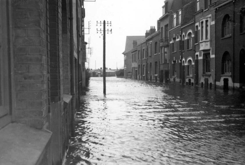
La digue et sa plage protège environ 17 000 personnes de l’arrière-pays dunkerquois. Le 1er févirer 1953, la digue cédait à la pression des flots, drossés par une violente tempête. Deux brèches se forment alors sur la digue du canal exuroire. L'eau envahit rapidement plusieurs quartiers en pleine nuit, notamment la cité du stade Tribut et les rues limitrophes. L'eau penetre dans les rues et inonde les sous-sols des habitations.

La Rue Paul Dufour à Dunkerque le 1er février 1953 (Source : AGUR)
L'évolution du trait de côte
Situé à l’interface entre la terre et la mer, le littoral est un milieu mobile qui fluctue sous l’effet combiné de processus naturels et anthropiques. Ces évolutions se traduisent par des phénomènes d’accrétion (avancée de la terre sur la mer sous l’effet d’une accumulation de matériaux) ou d’érosion (départ de matériaux vers la mer participant au recul du trait de côte et/ou à l’abaissement des plages).
Par grande profondeur, les sédiments qui tapissent les fonds marins se déplacent au gré des courants de marée. A proximité de la côte, ces déplacements s'effectuent essentiellement sous l'action des courants de houle (oscillation régulière de la surface de la mer, indépendante du vent local). Ce transport littoral varie en intensité et en direction en fonction des caractéristiques de la houle.
Sur des périodes de temps longues, la somme des transports littoraux côtiers provoque un mouvement net de sédiments orienté dans une seule direction. Ce mouvement est qualifié de dérive littorale.
Les ouvrages de défense « classiques » peuvent perturber cette dérive littorale, rompant ainsi l'équilibre sédimentaire établi. Ils provoquent alors une accumulation de sable en amont et une érosion en aval.
Les obstacles naturels (caps ou estuaires) ou artificiels (ouvrages portuaires...) bloquant totalement les sédiments de la dérive littorale marquent les limites de ce que l'on appelle des unités seédimentaires. Dans ces dernières, toute intervention peut potentiellement avoir des répercussions sur les secteurs voisins.
Le littoral des Wateringues est concerné par trois unités sédimentaires :
-
UG3: Boulogne-sur-Mer - Dunkerque ouest ;
-
UG4 : Dunkerque ouest - Dunkerque est ;
-
UG5 : Dunkerque est - Frontière belge.
Les ouvrages des avant-ports ouest et est de Dunkerque en sont les jalons. Entre ces unités, le transit sédimentaire s'effectue de l'ouest vers l'est.
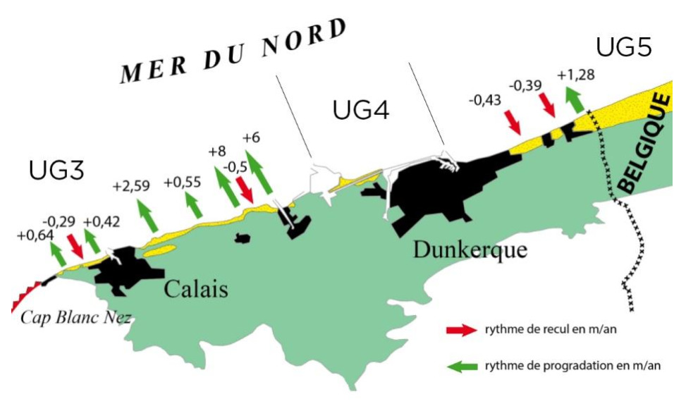
Rythmes d'évolution du trait de côte entre 1963 et 2009 (Source : Crapoulet, 2015)
Le maintien de la plage
La plage de la digue des Alliés est en aval de la dérive littorale orientée Ouest – Est. Accolée à la jetée de Malo les Bains, très peu de sédiment s’y dépose, il n’y a que du transport vers l’Est. Il y a donc nécessité de compenser cette perte par des rechargements d’entretien. Le sable refoulé vient de l’ouest ce qui permet de recréer artificiellement le transit sédimentaire naturel.
La digue des Alliés, ouvrage indispensable à la protection au territoire des waterinques est située à la limite ouest de l'UG5. Le transit sedimentaire étant rompu au droit de la digue, l'érosion s'y manifeste par un abaissement de la plage. Celle-ci peut à terme déstabiliser l'ouvrage. Pour y remédier, et afin de protéger la digue des assauts de la mer, un rechargement de la plage d'1,5 million de m° de sable a été effectué en 2011 et 2014, élevant son niveau d'environ 7 mètres.
Aussi afin de limiter les envols de sable, des filets brise vent ont été installés et des oyats plantés (reconstituant ainsi un milieu dunaire). L'efficacité de ces dispositifs a été immédiat. Désormais, des rechargements sont régulièrement réalisés bour assurer la protection de la digue et de la population.
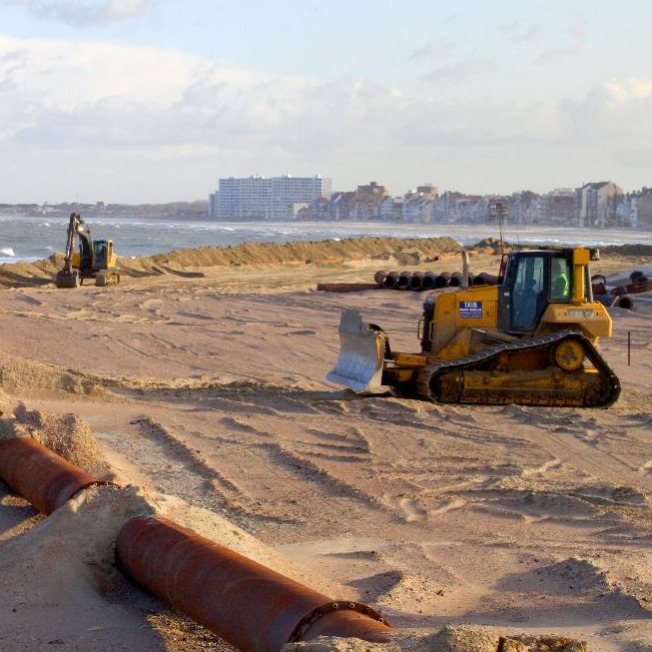
Rechargement de la digue des Alliés (Source : AGUR)
Questions :
1 - Au droit de la digue des Alliés, pensez-vous que l'évolution de la plage est en accrétion ou en érosion? Justifiez.
2 - Pourquoi le maintien de la plage de la digue des Alliés est si crucial?
3 - Donnez trois actions ou dispositifs mis en place par l'Homme pour maintenir la plage?
4 - En quoi consiste la dérive littorale? A Dunkerque, dans quelle direction est orientée cette dérive?
5 - OBLIGATOIRE En plus d'être récréative, cette cache a un but scientifique. Afin améliorer la connaissance tout en sensibilisant les citoyens à la mobilité du littoral, vous trouverez sur place une station CoastSnap. Inspirée d’une initiative australienne, cette démarche permet, en contrôlant l’angle de vue et le panorama depuis un point fixe, de constituer une base importante de photos pour observer l’évolution du littoral tout en sensibilisant les citoyens au caractère éminemment mobile de la bande côtière. Cet outil participatif permet à n'importe qui muni d'un smartphone, de contribuer à l'observation du littoral et plus particulièrement le secteur très sensible de la digue des Alliés, en prenant une photo (voir exemple ci-dessous) depuis le socle disponible au PZ. Afin d'avoir un suivi optimal, je vous remercierai de faire correspondre votre photo jointe à votre log à la date d'enregistrement et de la prendre le jour.
Si vous êtes intéréssés par le dispositif, vous pouvez partager votre photo aux coordonnées indiquées au PZ (facultatif).
Rappel concernant les « Earthcaches » : Il n'y a pas de conteneur à rechercher ni de logbook à renseigner. Il suffit de se rendre sur le lieu, de bien lire le descriptif, d’observer et de comprendre pour pouvoir répondre aux questions ci-dessus. Une fois les réponses trouvées et la photo effectué de jour (toute photo de nuit entrainera la supression du log), envoyez-les par mail via la messagerie "geocaching.com".
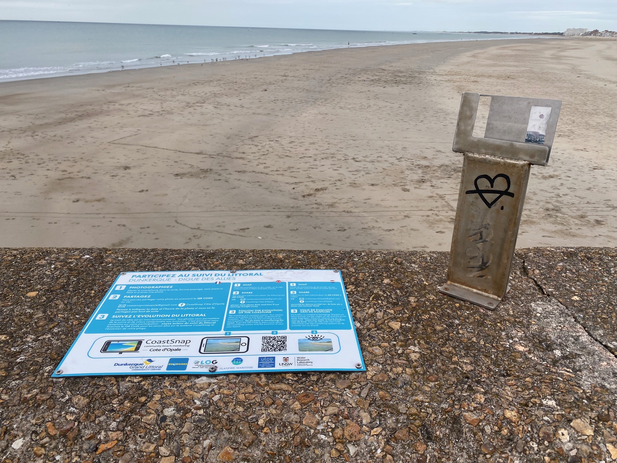

En haut : Socle à partir duquel il faut disposer le smartphone pour faire la photo demandée
En bas : Exemple d'une photo prise depuis la station CoastSnap

The Digue des Alliés
The Digue des Alliés is a 900m long structure belonging to the State, under delegated project management to the Grand Port Maritime de Dunkerque (GPMD). It separates the sea from the Exutoire canal, one of the main outlets to the sea for the continental waters of the Wateringues. The dike was built in 1876 and was the subject of major repair work, particularly following the storms of 1949 and 1953, which each caused breaches. Its structure is atypical: a concrete core, sandy refills on both sides, a sea side facing in gently sloping masonry and a canal side facing covered with reinforced concrete slabs.
The dyke and its beach protect around 17,000 people in the Dunkirk hinterland. On February 1, 1953, the dyke gave way to the pressure of the waves, driven by a violent storm. Two breaches then form on the embankment of the outlet canal. The water quickly invaded several districts in the middle of the night, in particular the city of the Tribute stadium and the neighboring streets. The water enters the streets and floods the basements of the houses.
Rue Paul Dufour in Dunkirk on February 1, 1953 (Source: AGUR)
The evolution of the coastline
Located at the interface between land and sea, the coastline is a mobile environment that fluctuates under the combined effect of natural and anthropogenic processes. These changes result in phenomena of accretion (advance of the land on the sea under the effect of an accumulation of materials) or erosion (departure of materials towards the sea participating in the retreat of the coastline and/or at the lowering of the ranges).
At great depths, the sediments covering the seabed move with the tidal currents. Near the coast, these movements are essentially carried out under the action of wave currents (regular oscillation of the sea surface, independent of the local wind). This coastal transport varies in intensity and direction depending on the characteristics of the swell.
Over long periods of time, the sum of coastal littoral transport causes a net movement of sediments oriented in a single direction. This movement is called littoral drift.
“Classic” defense structures can disrupt this coastal drift, thus breaking the established sedimentary balance. They then cause an accumulation of sand upstream and erosion downstream.
The natural (headlands or estuaries) or artificial (harbour structures, etc.) obstacles totally blocking the sediments of the coastal drift mark the limits of what are called sedimentary units. In the latter, any intervention can potentially have repercussions on neighboring sectors.
The Wateringues coastline is affected by three sedimentary units:
- UG3: Boulogne-sur-Mer - West Dunkirk ;
- UG4: West Dunkirk - East Dunkirk ;
- UG5: East Dunkirk - Belgian border.
The works of the western and eastern outer harbors of Dunkirk are the milestones. Between these units, sediment transit takes place from west to east.

Coastline change rates between 1963 and 2009 (Source: Crapoulet, 2015)
Maintaining the beach
Dike des Alliés beach is downstream of the west-east oriented littoral drift. Attached to the jetty of Malo les Bains, very little sediment is deposited there, there is only transport to the East. It is therefore necessary to compensate for this loss by maintenance recharges. The repressed sand comes from the west, which makes it possible to artificially recreate the natural sedimentary transit.
The dyke of the Allies, work essential to the protection of the territory of water inques is located at the western limit of UG5. The sedimentary transit being broken at the level of the dyke, erosion manifests itself there by a lowering of the beach. This can ultimately destabilize the structure. To remedy this, and in order to protect the seawall from the onslaught of the sea, the beach was replenished with 1.5 million m⊃3; of sand in 2011 and 2014, raising its level by around 7 metres.
Also in order to limit the flight of sand, windbreak nets have been installed and marram grass planted (thus restoring a dune environment). The effectiveness of these devices was immediate. From now on, reloadings are regularly carried out to ensure the protection of the dyke and the population.
Reloading of the Allied dyke (Source: AGUR)
Questions :
1 - To the right of the Allied dyke, do you think that the evolution of the beach is in accretion or erosion? Justify.
2 - Why is the maintenance of the Allied seawall beach so crucial?
3 - Give three actions or devices put in place by man to maintain the beach?
4 - What is littoral drift? In Dunkirk, in which direction is this drift oriented?
5 - MANDATORY In addition to being recreational, this cache has a scientific purpose. In order to improve knowledge while raising citizens' awareness of coastal mobility, you will find a CoastSnap station on site. Inspired by an Australian initiative, this approach makes it possible, by controlling the angle of view and the panorama from a fixed point, to constitute an important database of photos to observe the evolution of the coast while raising awareness among citizens of the eminently mobile nature of the coastal strip. This participatory tool allows anyone with a smartphone to contribute to the observation of the coast and more particularly the very sensitive sector of the Allied dyke, by taking a photo (see example below) from the base available at the PZ. In order to have an optimal follow-up, I will thank you for matching your photo attached to your log on the date of recording and taking it on the day.
If you are interested in the device, you can share your photo at the coordinates indicated at the PZ (optional).
Reminder concerning “Earthcaches”: There is no container to search for or logbook to fill in. All you have to do is go to the place, read the description carefully, observe and understand to be able to answer the questions above. Once the answers have been found and the photo taken during the day (any night photo will lead to the deletion of the log), send them by email via the "geocaching.com" messaging system.
Above: Base from which the smartphone must be placed to take the requested photo
Bottom: Example of a photo taken from the CoastSnap station