

Cette Earth Cache a pour but de vous faire (re)découvrir les méandres morts.
La Rance
Sur une longueur d'un peu plus de 100 kilomètres, le fleuve côtier la Rance coule à travers des unités géologiques très variées, tant en nature qu’en âge. Ces unités appartiennent à deux des grands domaines structuraux aujourd’hui reconnus dans le Massif armoricain:
- le domaine centre-armoricain à l’histoire essentiellement paléozoïque, dans lequel s’inscrit sa haute vallée.
- le domaine nord-armoricain à l’histoire paléozoïque et plus ancienne, dans lequel s’inscrivent sa moyenne vallée et sa partie maritime.
Ces deux domaines sont séparés par un grand accident tectonique qui est globalement orienté est-ouest, le décrochement nord-armoricain.
Carte géologique simplifiée de la Bretagne et position de la Rance et de Dinan. 🔽
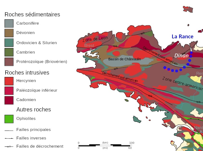
Au niveau de Dinan et du plateau de Taden, elle entaille les granites et forme un méandre: la Courbure.
Histoire de la Courbure
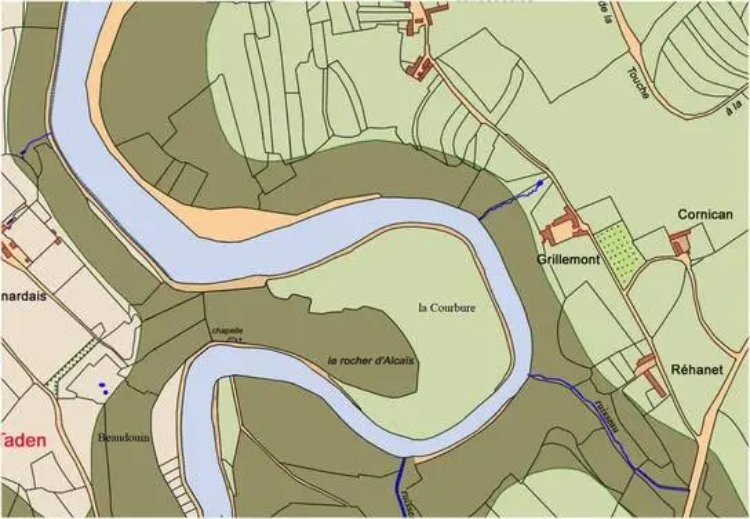
Déjà appelé au XVII siècle "la Courbure", le méandre de la rivière a toujours posé problème pour les bateaux arrivant du port de Dinan, avant la réalisation du canal d’Ille et Rance. Ce canal fut commencé en 1804 afin de pouvoir contrer le blocus anglais dirigé contre l’Empire, afin de pouvoir réunir la Manche à l’Atlantique, et celui-ci sera inauguré en la plaine fluviale de Taden en 1836 ; dans sa totalité il comporte en tout 48 écluses. Outre le contournement qui faisait perdre du temps, des eaux souvent marécageuses rendaient la navigation peu aisée. Ce méandre avait cependant un avantage: celui de briser naturellement la remontée violente en le port de Dinan des fortes marées d’équinoxe.
La Courbure avant 1804. 🔽
La Courbure en 1844. 🔽
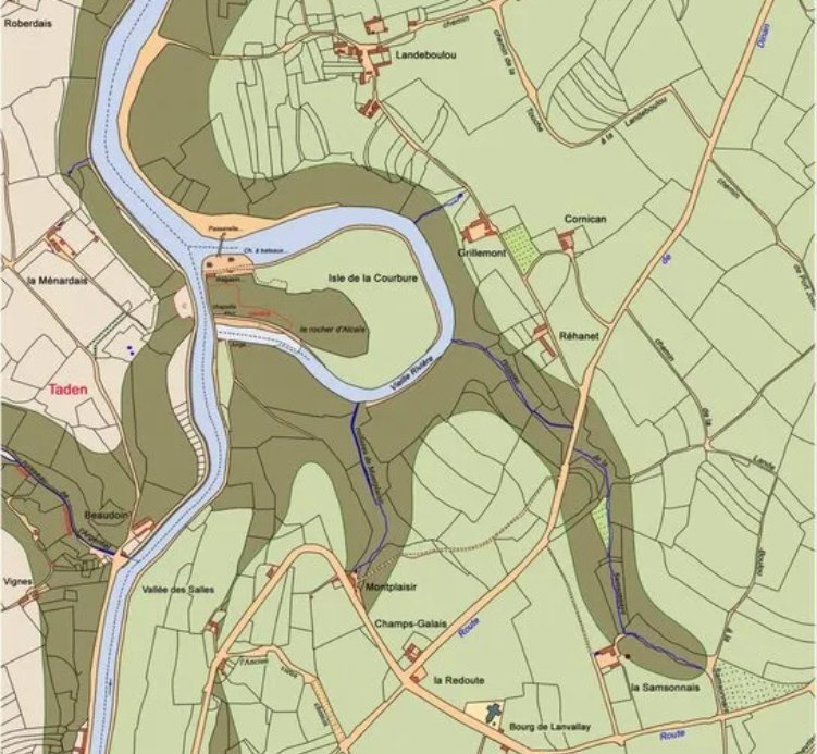
La Courbure aujourd'hui (carte topographique IGN). 🔽

L'anthropisation
L'anthropisation désigne la modification d'un milieu dit « naturel » par les activités humaines. On peut aussi parler d'artificialisation mais ce terme désigne plutôt un état avancé d'anthropisation. L'anthropisation est un processus, le résultat est un milieu anthropisé.
Les bras anciens
Lorsqu'une rivière atteint une zone de plaine étendue, souvent dans son cours final vers la mer ou vers un lac, elle décrit de nombreux méandres. Au voisinage d'un coude de rivière, des sédiments se déposent sur la rive convexe (la rive ayant le plus petit rayon). En revanche, l'érosion latérale intervient sur le côté ou le bord concave (le bord avec le rayon le plus large) en raison de la coupe inférieure. Le dépôt continu sur la berge convexe et l'érosion de la berge concave provoquent la formation d'un méandre très prononcé, les deux berges concaves se rapprochant. Le col étroit entre les deux rives concaves voisines finit par être coupé, soit par l'érosion latérale des deux rives concaves, soit par de forts courants d'inondation. De fait, une nouvelle chaîne est créée avec une rivière plus droite, qui s'approfondit immédiatement au fur et à mesure que l'eau moindre coule plus vite car l'itinéraire est plus court et la boucle du méandre est abandonnée. Lorsque le dépôt scelle enfin le raccourci du canal de la rivière, le bras mort se forme. Ce processus se déroule dans le temps, avec une durée différente, de plusieurs années à plusieurs décennies et peut parfois être essentiellement statique.
Un bras ancien (familièrement bras mort ou méandre mort) est la partie d'une rivière qui est coupée du ruisseau principal à une extrémité par des éléments naturels (barres de sable ou de gravier) ou artificiels (déversoir ou barrage). Les bras anciens sont plus plats et plus naturels que le bras principal. Puisqu'il n'y a pas ou peu d'écoulement à travers eux, ils ont tendance à submerger ou même à s'envaser, mais servent de drain d'urgence en cas d'inondation. Le méandre mort est la partie abandonnée d'un ancien méandre, lorsque le cours d'eau s'est tracé un nouveau lit plus court. Le méandre qui devient un bras mort d'une rivière finit par s'envaser.
Sources
Comment valider cette Earth Cache
Petit rappel concernant les "Earth Caches": il n'y a pas de contenant à rechercher, ni de logbook. Il suffit de se rendre sur les lieux, de répondre aux questions ci-dessous. Vous pouvez loger en "Found it" et envoyez-moi vos propositions de réponses, soit via mon profil, soit via la messagerie geocaching.com (Message Center), et je vous contacterai en cas de problème.

Questions
- 0: une photo de vous ou d'un objet vous représentant au premier waypoint et montrant la Rance, est obligatoire pour valider cette Earth Cache.
- 1a: Pourquoi la Rance possède des méandres?
- 1b: Dans quel domaine géologique coule-t'elle ici? Et dans quelles roches pour la moyenne vallée?
- 2: Parcourez les 5 waypoints; qu'observez-vous à chacun des waypoints par rapport à l'eau (vous pouvez numéroter les réponses 2a, 2b, 2c, 2d et 2e)?
- 3: Peut-on parler de méandre mort? Si oui pourquoi et quelle en est la cause?
Merci par avance de ne pas poster de spoiler dans vos logs!
Bon amusement, bonnes recherches, bon Geocaching!

This Earth Cache aims to make you discover a detrital rock.
The Rance river
Over a length of just over 100 kilometres, the coastal river Rance flows through a wide variety of geological units, both in nature and age. These units belong to two of the major structural domains currently recognised in the Armorican Massif:
- the Central Armorican area, with its essentially Palaeozoic history, which forms the backdrop to the upper valley.
- lhe North Armorican area, with its Palaeozoic and earlier history, forms part of the mid-valley and maritime area.
These two areas are separated by a major east-west tectonic fault, the North Armorican Fault.
Simplified geological map of Brittany and position of the Rance river and Dinan. 🔽
At Dinan and the Taden plateau, it cuts through the granite to form a meander: the Courbure..
History of the Courbure
Already known as "la Courbure" in the 17th century, the meander of the river has always posed a problem for boats arriving from the port of Dinan, before the Ille et Rance canal was built. This canal was begun in 1804 to counter the English blockade against the Empire, in order to link the Channel to the Atlantic, and was inaugurated on the Taden river plain in 1836; in its entirety it comprises 48 locks. In addition to the time-consuming bypass, the often marshy waters made navigation difficult. However, this meander had one advantage: it naturally broke the violent rise in the port of Dinan caused by the high equinox tides.
La Courbure before 1804. 🔽
La Courbure in 1844. 🔽
La Courbure today (IGN topographical map). 🔽
Anthropisation
Anthropisation refers to the modification of a so-called "natural" environment by human activities. We can also speak of artificialisation, but this term refers to an advanced state of anthropisation. Anthropisation is a process, and the result is an anthropised environment.
Ancient arms
When a river reaches an extensive lowland area, often in its final course towards the sea or a lake, it meanders extensively. In the vicinity of a river bend, sediment is deposited on the convex bank (the bank with the smallest radius). On the other hand, lateral erosion occurs on the concave side or edge (the edge with the widest radius) because of the lower cut. Continuous deposition on the convex bank and erosion of the concave bank result in the formation of a very pronounced meander, with the two concave banks coming together. The narrow neck between the two adjacent concave banks is eventually cut, either by lateral erosion of the two concave banks or by strong flood currents. In effect, a new chain is created with a straighter river, which immediately deepens as the lesser water flows faster because the route is shorter and the meander loop is abandoned. When the deposit finally seals the shortcut in the river channel, the dead arm is formed. This process takes place over time, varying in duration from several years to several decades, and can sometimes be essentially static.
An old branch (colloquially dead branch or dead meander) is the part of a river that is cut off from the main stream at one end by natural features (sand or gravel bars) or man-made features (weir or dam). Older branches are flatter and more natural than the main branch. Since there is little or no flow through them, they tend to submerge or even silt up, but serve as an emergency drain in the event of flooding. A dead meander is the abandoned part of an old meander, when the watercourse has formed a new, shorter bed. A meander that becomes a dead branch of a river ends up silting up.
Sources
How to validate this Earth Cache
A reminder about the "Earth Caches": there is no container to look for, nor a logbook. You just have to go to the place and answer the questions below. You can log in "Found it" and send me your suggestions for answers, either via my profile, or via the geocaching.com message center, and I will contact you if there is a problem.
Questions
- 0: A photo of you or an object representing you at the first waypoint and showing the Rance is required to validate this Earth Cache.
- 1a: Why does the River Rance meander?
- 1b: In what geological area does it flow here? And what rocks does the mid-valley flow through?
- 2: Go through the 5 waypoints; what do you observe at each waypoint in relation to the water (you can number the answers 2a, 2b, 2c, 2d and 2e)?
- 3: Can we talk about a dead meander? If so, why and what is the cause?
Thank you in advance for not posting spoilers in your logs!
Good research, and happy Geocaching!