注意: 1. 入山申請是必要的,可在登山前30天線上網站申請。 Note:1. Applying permission for hiking is needed. It is open for applying 30 days before your hiking. Check this website for official apply.
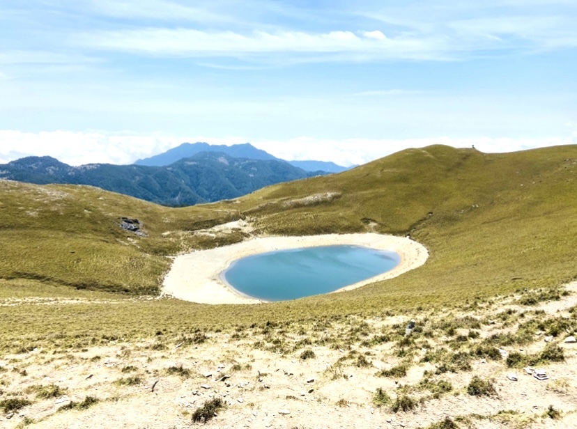
高山有別於平地的色澤,湖水為這片風景添上一點藍,不過,嘉明湖有更多色澤藏在岩石裡。
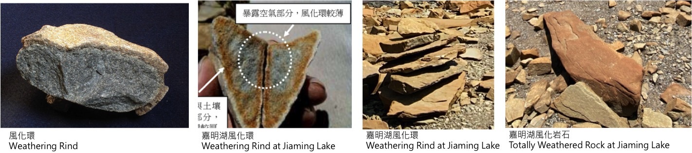
嘉明湖的石頭大部分為板岩和變質砂岩。近年研究大略支持嘉明湖為冰斗湖,附近的石頭可能為岩石漂礫或冰磧,這些岩石的斷面呈現不同顏色,這個獨特的特徵稱為風化環,可顯示風化的程度與過程。
地質知識一,風化影響因素: 風化讓岩石、土壤、和礦物質變得脆弱碎裂開來,透過一些影響因素像是空氣、水、和生物有機質。接觸面積也是一項影響因素:接觸面積越大、風化越多。岩石特性也是另一項影響因素,像是板岩劈理會造成更多接觸面積。
地質知識二,風化環: 風化環是岩石斷面中不同顏色、化學變化的外圍區域,通常發生於沖積扇、殘積層、或冰川堆積物的地表或深埋岩石之表面區域。風化環的意義是岩石的外層持續接觸空氣或地下水的時間長短。基本上,風化環會因為岩石礦物質而更為明顯,像是鐵、錳、和二氧化矽,這些物質氧化之後會形成黃褐色、或鐵鏽色。
Intro: High mountain has different colors from the ground. The lake brings a egg-shaped blue color into this scene. However, there are more subtle colors among rocks surrounding Jiaming Lake.
Uniqueness: Rocks at Jiaming Lake are mostly slate and meta sandstone. Jiaming lake is probably a cirque lake supported by recent research. The surrounding rocks may be glacial erratics or moraines, which are rocks left by moving glaciers. The surfaces of these rocks are often weathered. Some of these rocks were broken and showed a fracture surface with different colors inside. This unique feature is called a weathering rind. It tells the degree and process of weathering.
Knowlege 1, Weathering influecing factors: Weathering breaks down rocks, soil, and minerals through contact with factors like air, water, and biological organisms. The Contact area is also an influencing factor, which is more contact area, more weathering. The characteristics of rocks is another influencing factor, like slate cleavage producing more contact area.
Knowledge 2, Weathering rind: A weathering rind is a discolored, chemically altered, outer zone or a layer of discrete rock fragment formed by the process of weathering. They typically occur either lying on the surface of the ground or buried within sediments such as alluvium, colluvium, or glacial till. A weathering rind represents the alteration of the outer portion of a rock by exposure to air or near surface groundwater over a period of time. Typically, a weathering rind may be enriched with either iron or manganese, and silica, and oxidised to a yellowish red to reddish color.

Logging Tasks 登錄任務
Please, leave no trace. Don't break rocks. Just observe those broken rocks on the ground. 無痕山林。請不要破壞岩石,觀察地表上的岩塊破裂面即可。
1. Do you discover the weathering surface or weathering rind of rocks? Compare the rocks at the posted coordination and waypoint, which spot has a thicker weathering rind or more weathering areas?請觀察當地的岩石,有觀察到風化表面或風化環嗎? 比較公布點與參照點,哪一個位置的岩石有較厚風化環、較大風化面積?
2. Observe those weathering's influencing factors in the environment. Explain your answer why they are different in degree. 觀察當地環境的風化影響因子,解釋為什麼兩個區域的岩石風化程度不同?
3. Photo the weathered rocks or the weathering rind with you, your identifying items, or your GPS device. 請與風化岩石或風化環拍照,照片內容包含風化岩石/風化環與你、你的代表物、或你的GPS裝置。
Log this cache "Found it" and send me your suggested answers, and I will contact you if there is a problem. Don't post answers in the log except logging task 3, please. Hope you like this earthcache and welcome some favorite points. 請不要在log中公布你的答案。線上登錄這個地質寶,請寄到Geocaching.com的信箱,若有什麼問題,會再回覆給你。希望你喜歡這個地質寶,歡迎給予FP,有任何問題請寄送訊息。
Reference
應用風化環相對定年法探討冰川後退模式-以三叉山、嘉明湖為例
三叉山地區第四紀冰川後退研究初探