La Earthcache / The Earthcache
► Contexte géologique local
La région entre la Bourboule et le Mont Dore est marquée par le lit de la Dordogne qui prend sa source au Puy de Sancy.
Elle prend place au cœur du massif volcanique de la chaîne des Puys.
Ces formations volcaniques récentes (quelques millions d'années) forment un ancien point chaud, permettant la mise en place de systèmes aquifères originaux, des sources d'eau chaude thermales.
► Thermales, vous avez dit thermales ?
Les sources thermales, ou sources chaudes, sont des résurgences naturelles d'eau chaude fortement minéralisées dont la présence est souvent liée à un gradient géothermique supérieur à la moyenne.
En profondeur, la croûte terrestre présente un gradient de température avec la profondeur, appelé gradient géothermique.
Plus on creuse profondément, plus la température augmente.
Dans une formation rocheuse "froide" (sédimentaires, plutoniques ou métamorphiques anciennes), ce gradient augmente de 3°C tous les 100 mètres de profondeur.

A proximité d'un système volcanique (ou d'un ancien système volcanique récent), ce gradient géothermique est beaucoup plus élevé, permettant à des eaux puisées à relativement faible profondeur (quelques centaines de mètres) de sortir à des températures élevées.
Ce qui caractérise une source thermale est :
- Sa température significativement élevée à sa sortie en surface (température de plus de 8.3 degrés de celle de l'eau de surface).
- Sa richesse en minéraux, la température élevée des eaux thermales augmentant leur capacité de dissolution des minéraux au cours de leur voyage à travers les roches.
Les eaux du Croizat sont captées à 220 mètres et traversent les formations locales.
Elle est riche en arsenic, chlore, chlorobicarbonate et est légèrement soufrée.
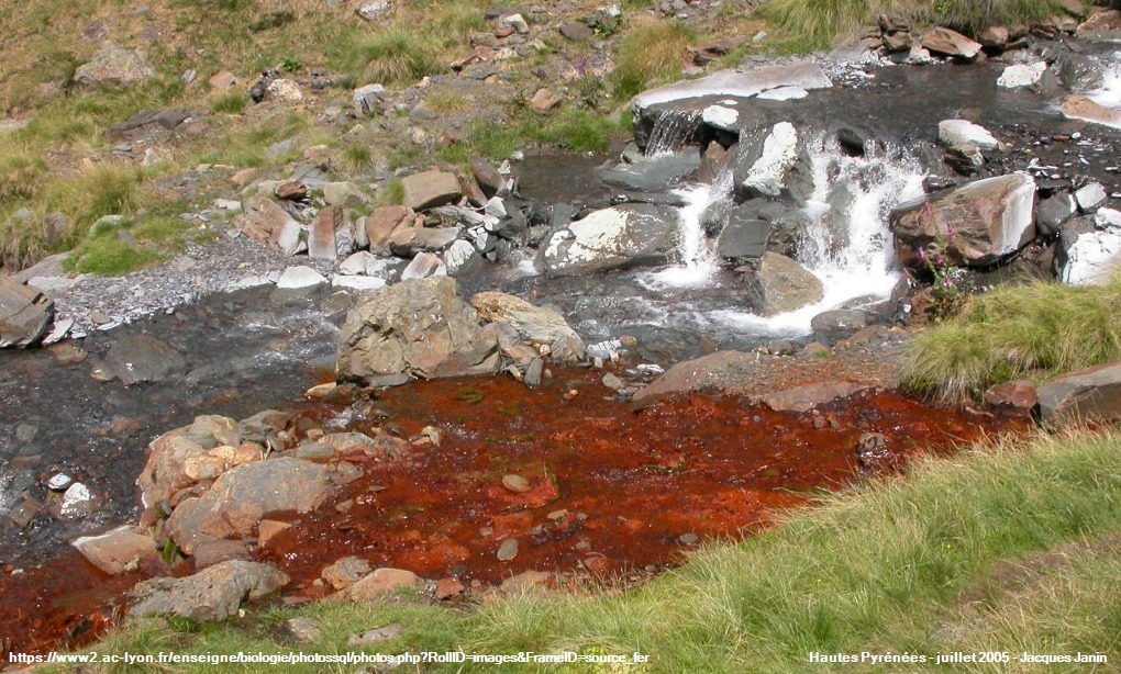
► La Ferruginisation, un processus biologique
Le fer contenu dans les eaux est issu de l'altération des silicates des granites et autres roches crustales par les eaux acides chargées de CO2.
Ils s'agit d'ions ferreux (Fe2+) qui restent en solution dans les eaux souterraines ; on obtient alors une eau ferrugineuse, une variété d'eau minérale riche en ions Fe2+.
En s'approchant de l'air libre, riche en dioxygène (21% d'O2), ces eaux ferrugineuses subissent une oxydation des ions ferreux en solution pour donner des ions ferriques Fe3+ insolubles.

Cette oxydation a lieu sous l'action de bactéries ferroxydantes.
Les bactéries utilisent l'énergie libérée par cette oxydation pour assurer leurs besoins énergétiques et réaliser la transformation de CO2 en matière organique (ce sont des bactéries chimiolithotrophes).
Ce Fe3+ précipite sous forme d'hydroxydes ferriques et forme des dépôts qui colorent vivement le fond du ruisseau et vont former des encroûtements métalliques de couleur rouge vif (rouille) pouvant avoir plusieurs centimètres d'épaisseur.
► Local geological context
The region between Bourboule and Mont Dore is marked by the bed of the Dordogne which has its source at Puy de Sancy.
It takes place in the heart of the volcanic massif of the Puys chain.
These recent volcanic formations (a few million years) form an ancient hot spot, allowing the establishment of original aquifer systems, thermal hot springs.
► Thermals, did you say thermals?
Thermal springs, or hot springs, are natural resurgences of highly mineralized hot water whose presence is often linked to a higher than average geothermal gradient.
At depth, the earth's crust exhibits a temperature gradient with depth, called the geothermal gradient. The deeper you dig, the higher the temperature.
In a "cold" rock formation (sedimentary, plutonic or ancient metamorphic), this gradient increases by 3°C for every 100 meters of depth.
Near a volcanic system (or a recent old volcanic system), this geothermal gradient is much higher, allowing water drawn from relatively shallow depths (a few hundred meters) to come out at high temperatures.
What characterizes a thermal spring is:
- Its significantly high temperature when it leaves the surface (temperature more than 8.3 degrees above that of the surface water).
- Its richness in minerals, the high temperature of the thermal waters increasing their ability to dissolve minerals during their journey through the rocks.
The waters of the Croizat are collected at 220 meters and cross the local formations. It is rich in arsenic, chlorine, chlorobicarbonate and is slightly sulphurous.
► Ferruginization, a biological process
The iron contained in the waters comes from the alteration of the silicates of the granites and other crustal rocks by acid waters charged with CO2.
They are ferrous ions (Fe2 +) which remain in solution in groundwater; ferruginous water is obtained, a variety of mineral water rich in Fe2 + ions.
Approaching the open air, rich in oxygen (21% O2), these ferruginous waters undergo oxidation of ferrous ions in solution to give insoluble ferric Fe3 + ions.
This oxidation takes place under the action of ferroxydantes bacteria.
Bacteria use the energy released by this oxidation to meet their energy needs and carry out the transformation of CO2 into organic matter (these are chemilithotrophic bacteria).
This Fe3 + precipitates in the form of ferric hydroxides and forms deposits which strongly color the bottom of the stream and will form metallic crusts of bright red (rust) color which can be several centimeters thick.
► Sources bibliographiques / Bibliographical sources
Les Questions / The Questions
La lecture attentive du descriptif de la cache, ainsi qu'une observation des éléments de terrain et un peu de déduction sont normalement suffisants pour répondre aux questions de cette EarthCache.
A careful reading of the description of the cache, as well as observation of terrain features and some deduction is usually sufficient to answer questions of this EarthCache.
Questions pour valider :"Sources Thermales au Croizat"
Questions to validate: "Thermal springs in Le Croizat"
- Question 0 : Prenez sur place une photo de vous ou d'un élément vous identifiant avec la Source du Croizat et la Dordogne en arrière plan.
Cette photo devra au choix nous être transmise avec les réponses ou être ajoutée à votre log.
- Question 0 : Take a photo of yourself or something that identifies you with the Source du Croizat and the Dordogne in the background.
This photo will have to be sent to us with the answers or to be added to your log.
- Question 1 : En arrivant près de la source du Croizat, que voyez-vous se dégager ? Trempez votre main dans l'eau et évaluez sa température. Est-ce que cela explique votre première observation ?
- Question 1 : Arriving near the Croizat source, what do you see emerging? Dip your hand in the water and assess its temperature. Does this explain your first observation?
Allez au bord de la Dordogne et trempez votre main dans le cours de la rivière.
Go to the edge of the Dordogne and dip your hand in the course of the river.
- Question 2 : Estimez la température de l'eau surfacique. En comparant celle-ci avec votre observation de la source du Croizat, pouvez-vous qualifiez cette dernière de thermale ? Justifiez votre réponse.
- Question 2 : Estimate the surface water temperature. By comparing this with your observation of the source of Croizat, can you qualify the latter as thermal? Justify your answer.
- Question 3 : En utilisant le graphique du gradient thermique et les informations du descriptif, quelle devrait être la différence de température entre l'eau surfacique et l'eau de la source du Croizat ? Expliquez la variation entre ce calcul théorique et l'observation réelle faite dans les questions 1 et 2 en vous aidant du descriptif.
- Question 3 : Using the thermal gradient graph and the information from the description, what should be the temperature difference between the surface water and the Croizat spring water? Explain the variation between this theoretical calculation and the real observation made in questions 1 and 2 using the description.
Observez de plus près les pierres de la margelle à l'opposé du chemin principal (voir photo WP1).
Take a closer look at the stones of the coping opposite the main path (see photo WP1).

- Question 4 : Comparez la couleur des pierres entre les zones immergées et celles à l'air libre. Quelle est l'origine de cette différence et expliquez son lien avec l'eau du Croizat.
- Question 4 : Compare the color of the stones between the submerged areas and those in the open air. What is the origin of this difference and explain its link with Croizat water.
Vous pouvez vous loguer sans attendre notre confirmation,
mais vous devez nous envoyer les réponses en même temps soit par mail via notre profil (
fafahakkai), soit via la messagerie geocaching.com (Message Center).
S'il y a des problèmes avec vos réponses nous vous en ferons part.
Les logs enregistrés sans réponses et sans photo seront supprimés.
You can log this cache without waiting for our confirmation, but you must send us the answers at the same time, by e-mail via our profile (fafahakkai) or by the system of Message Center of geocaching.com.
If there is a problem with your answers we will notify you. The logs recorded without answers and photo will be deleted.
Rappel concernant les « Earthcaches »: Il n'y a pas de conteneur à rechercher ni de logbook à renseigner. Il suffit de se rendre sur les lieux, de répondre aux questions ci-dessus et de nous renvoyer les réponses.
Reminder concerning "Earthcaches": there is neither a container to look for nor a logbook to sign. One need only go to the location, answer to the differents questions and send us the answers.