Welcome to Emerald Hill, or rather, a hidden side of this historic enclave in the heart of the Orchard Road district. This cache will bring you to a “secret” park hidden among the dense urban landscape of the city. It’ll also teach you about what we can learn about the history of our cities, if only you care to look a little deeper at the clues.
The History
What you are going to experience here has been dubbed “scarchitecture”, formed by combining the words “scar” and “architecture”. The term, coined by the excellent design podcast “99% Invisible” captures the essence of this phenomenon:
“As cities evolve, architecture often fills in abandoned routes designed for cars and trains. Still, the remnants of old voids can persist in the shapes of new structures. Slicing against the grain of the city, these buildings are especially noticeable when they defy a rigid grid. The cuts they follow are rendered solid, resulting in a kind of architectural scar tissue as if the built environment were healing around old wounds.”
In the heart of Singapore’s city centre, a scar slices through the urban landscape, and for those who know of its presence, the signs are obvious.
As covered in the AL “A Track Through the City”, the Singapore – Malaysia railway line once had a different alignment than the one that has produced the “Rail Corridor” today. This older route cut through the city and the Orchard Road district to reach Newton Circus, before running parallel to Bukit Timah Road all the way to Beauty World, which was then known as Bukit Timah 7th Mile.
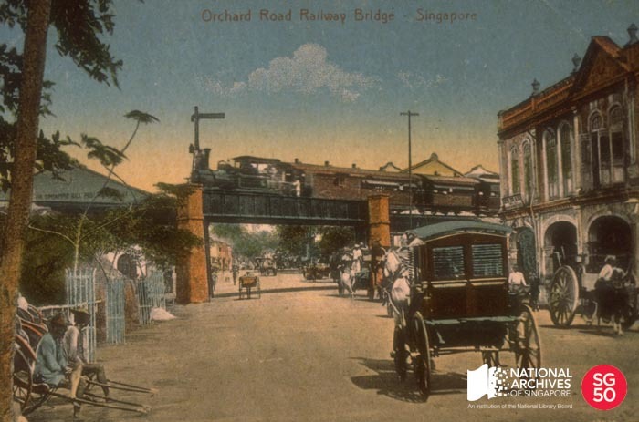
The “scar” of this alignment has now been mostly filled in by roads – Clemenceau Avenue (both the “North and “South” portion) was built on the empty land that was freed up by the removal of the tracks. The green space between Orchard and Penang Roads (where you can find this other cache of mine) conceals the embankment and cutting that were made for the tracks, but most passers-by will barely notice it. Finally, the railway bridge that once spanned Orchard Road has also all but disappeared.
But, one final vestige of this railway route remains… and, dear geocacher, you are going to re-discover this secret.
The cache
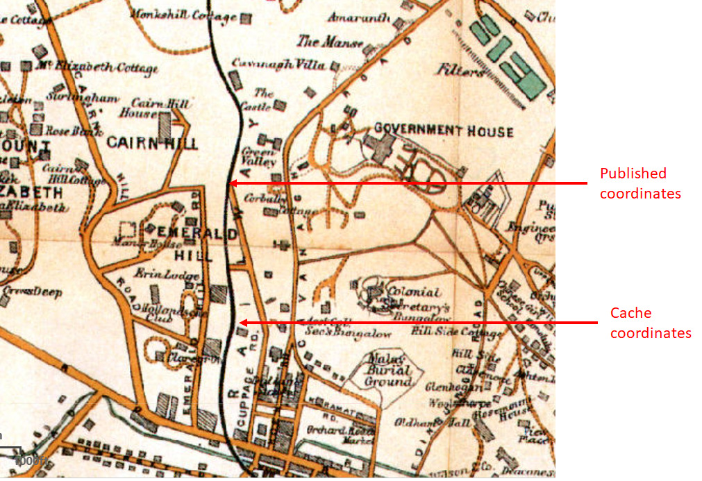
Between Cairnhill and Orchard Road, the tracks ran along the foot of Emerald Hill, behind the row of iconic Peranakan Houses on the eastern side of the hill. The “tracks” remain in place as a walking route, but barely anyone knows of its existence. The 1913 map below shows the position of the published coordinates and the final cache (with the thick black line denoting the railway tracks):
 You can try to find the cache based on the old map, but you will agree that it is much easier if I just give you the coordinates… and I will oblige.
At the published coordinates, you will find a “tunnel” with a yellow sign containing a prominent 5-digit number ABCDE. The digits should sum up to 19.
Find the product of the five digits i.e. A x B x C x D x E, and let it be F.
The final cache is located at:
N01 18.xxx E103 50.yyy
where xxx = F + 201and yyy = F + 412
The cache is hanging around the coordinates. Please be gentle with the cache – you need to only detach the container from the host and replace it as you found it. There is no need to detach the host.
Good luck and happy hunting!