Maré negra de 1990 – Porto Santo/ Black tide of 1990 – Porto Santo
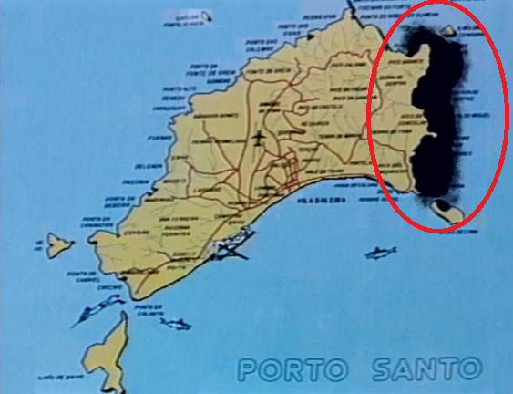
O dia 15 de janeiro de 1990, ficará para sempre marcado como o dia da chegada da maré negra à Ilha do Porto Santo. Uma enorme mancha de crude, conhecida como a “mancha da morte”, atingiu gravemente a costa do Porto Santo.
January 15, 1990, will forever be marked as the day the oil slick arrived on Porto Santo Island. A huge oil slick, known as the “stain of death”, seriously hit the coast of Porto Santo.
Esta situação originou-se, devido a um incidente num petroleiro. A 30 de dezembro de 1989 o petroleiro espanhol ARAGON derramou 25.000 toneladas de petróleo bruto no Oceano Atlântico, a cerca de 100 mi (161 Km) a NE do Porto Santo. A área de crude equivalia-se à da Ilha do Porto Santo. De acordo com a crítica social, após a notícia do acidente, as autoridades marítimas portuguesas e o governo da Madeira desdobraram-se em declarações, tentando fazer crer que a catástrofe ecológica não atingiria a Ilha Dourada.
This situation originated due to an incident on an oil tanker. On December 30, 1989, the Spanish oil tanker ARAGON spilled 25,000 tons of crude oil into the Atlantic Ocean, about 100 mi (161 km) NE of Porto Santo. The area of crude oil was equivalent to that of Porto Santo Island. According to social critics, after the news of the accident, the Portuguese maritime authorities and the government of Madeira made statements, trying to make people believe that the ecological catastrophe would not reach Ilha Dourada.

Imensos homens, principalmente porto-santenses, mas também madeirenses, e mais tarde, alguns do continente, trabalharam arduamente para pôr um fim ao crude na costa. Apesar de todo o esforço, a força de braços não era suficiente, e a maquinaria tardava em chegar. O difícil acesso às praias da costa leste do Porto Santo dificultou o processo. Algumas figuras de estado, quer nacional e regional, deslocaram-se ao terreno. Só as primeiras operações custaram 500.000 contos.
Huge men, mainly from Porto Santo, but also from Madeira, and later, some from the mainland, worked hard to put an end to crude oil on the coast. Despite all the effort, the strength of arms was not enough, and the machinery was slow to arrive. The difficult access to the beaches on the east coast of Porto Santo made the process difficult. Some state figures, both national and regional, went to the field. The first operations alone cost 500,000 contos.

As consequências desta maré negra foram catastróficas. Para além de todo o ecossistema marítimo ter sido afetado, os danos permanecerão durante dezenas ou centenas de anos. A fauna e a flora marítimas foram completamente arrasadas. Aqui, localizavam-se algumas espécies endémicas deste arquipélago. Na foto abaixo, podemos ver uma tartaruga a ser salva.
The consequences of this oil slick were catastrophic. In addition to the entire marine ecosystem being affected, the damage will remain for tens or hundreds of years. The marine fauna and flora were completely destroyed. Here, some endemic species of this archipelago were located. In the photo below, we can see a turtle being saved.

Por fim, se estiver interessado em saber mais sobre este tema, poderá ver o documentário, “Corsários voltam a atacar”. Este documentário aborda a maré negra do Porto Santo em 1990 e representou a RTP-Madeira na edição de 1990 da Mostra Atlântica de Televisão, sendo exibido pela TVE – Barcelona. É da autoria do Geógrafo Raimundo Quintal.
Finally, if you are interested in knowing more about this topic, you can watch the documentary, “Corsários voltam a atacar” (Corsairs attack again). This documentary addresses the oil slick in Porto Santo in 1990 and represented RTP-Madeira in the 1990 edition of the Mostra Atlântica de Televisão, being shown by TVE – Barcelona. It is authored by the Geographer Raimundo Quintal.
Link - https://www.youtube.com/watch?v=j-q9s51HpA0
[A cache/ The cache]
Esta cache pretende dar a conhecer esta enorme catástrofe que abateu-se sobre o Porto Santo, de uma vista privilegiada para a área afetada.
A tarefa de chegar à cache não será fácil, pois apenas será possível, se a maré estiver baixa. Porém, poderá arriscar, e seguir algumas partes do trilho a nado, quando a maré estiver cheia. Contudo, apenas é recomendado em situações de mar calmo. O vento forte, poderá também condicionar o acesso ao local. Em suma, busque sempre situações de bom tempo, coincidindo com a maré baixa.
Chegando ao fim do caminho junto ao mar, já perto da Ponta dos Ferreiros, terá de subir aproximadamente 25 metros da encosta, em que os iniciais 15 metros são sobre um solo bastante íngreme e escorregadio, isto é, de pedra solta. Quando estiver ao pé da localização da cache, procure por um buraco na parede, e encontrará a cache. Após fazer o registo, aproveite para observar toda esta baía e alguns dos fenómenos geológicos ao longo da mesma.
- Leve material de escrita;
- Leve calçado adequado;
- Caso vá de maré cheia (em situação de mar calmo), leve o material necessário para realizar todo o percurso em segurança;
- Tenha sempre muito cautela, principalmente a partir da Praia do Gavião;
- Procure sempre situações de segurança;
- Minimize ao máximo as interações com o meio natural;
This cache aims to make known this huge catastrophe that hit Porto Santo, from a privileged view of the affected area.
The task of reaching the cache will not be easy, as it will only be possible if the tide is low. However, you can take a risk, and follow some parts of the trail by swimming, when the tide is high. However, it is only recommended in calm sea situations. The strong wind may also condition access to the site. In short, always look for situations of good weather, coinciding with low tide.
Arriving at the end of the path by the sea, already close to Ponta dos Ferreiros, you will have to climb approximately 25 meters of the slope, in which the initial 15 meters are on a very steep and slippery ground, that is, loose rock. When you're near the cache location, look for a hole in the wall, and you'll find the cache. After registering, take the opportunity to observe this entire bay and some of the geological phenomena along it.
- Take writing material;
- Take suitable footwear;
- If you go at high tide (in a calm sea situation), take the necessary material to carry out the entire route safely;
- Always be very careful, especially from Praia do Gavião;
- Always look for security situations;
- Minimize interactions with the natural environment as much as possible;
Espero que tenha gostado!
I hope that you enjoyed!