
[05] Oppidum et géologie du plateau
par ipln | GCA64CY | Amboise

► La série ◄
Amboise est une ville située au cœur du Val de Loire, classé patrimoine mondial UNESCO.
Située à la confluence de la Loire et de l’Amasse, le développement d’Amboise fut fortement influencé par la géologie locale, depuis l’antique oppidum gallo-romain jusqu’à aujourd’hui.
La série [Promenade Géologique à Amboise] vous propose des EarthCaches invitant à la découverte du patrimoine amboisien à travers la nature des roches de construction, des phénomènes géologiques et hydrologiques.
► Partie 1 : Le site ◄
La Touraine se trouve dans la partie Sud-Ouest du vaste complexe géologique du Bassin parisien, qui se caractérise par la présence exclusive de roches sédimentaires. Au cours de centaines de millions d’années, le sol s’est constitué d’un empilement de couches de roches.
En s’écoulant, les eaux de la Loire ont creusé son lit en pénétrant dans les différentes couches du sol. Cette érosion a abouti à la formation de nombreuses falaises bordant le fleuve. La rivière de l’Amasse en fit de même jusqu’à sa confluence avec la Loire, formant ainsi un éperon rocheux : le plateau des Châtelliers. Un oppidum gallo-romain, appelé Ambacia, fut établi au sommet de cet éperon. Cet emplacement était hautement stratégique, dominant les vallées d’environ 50 mètres.
Cette ancienne cité fortifiée fut la capitale du peuple gaulois des Turons, qui donna son nom à la région. L’oppidum s’est développé autour d’un monument funéraire, appelé la Butte de César, occupant précisément le centre du plateau. Ce tertre artificiel, datant du Ve siècle av. J.-C. et haut de 6 mètres, est visible au Waypoint 2.
Un sanctuaire, ou fanum, comprenant un temple, des thermes et d’autres bâtiments publics, fut élevé au Ier siècle de notre ère. Les fondations sont encore visibles au Waypoint 3.
Durant l’Âge de Fer, l’oppidum s’étendait sur 50 hectares, étant l’un des plus grands de Gaule. Un rempart en terre fut édifié à l’Est, à environ 900 mètres de la pointe de l’éperon (Waypoint 1).

La visite de ce site archéologique permet également d’aborder l’analyse géologique du sous-sol du plateau. Après avoir étudié ces caractéristiques géologiques avec cette EarthCache, je vous invite à vous rendre sur place pour les observer de visu.
► Partie 2 : Formation du rempart ◄
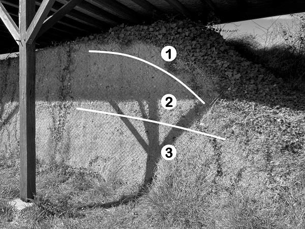
D’une longueur de 800 mètres et barrant le plateau, le rempart est entièrement artificiel : les Turons ont creusé dans le sol pour former un fossé extérieur, et ainsi élever le rempart. Par endroits, il pouvait mesurer jusqu’à 10 mètres de haut pour 25 mètres de large : cela en fait des coups de pelle !

Le rempart, ou vallum, fut coupé par le percement d’une route en 1978, selon un axe NE-SO : il est ainsi possible de directement observer la coupe du rempart ! Comme cette butte fut élevée en creusant le sol, on retrouve dans le rempart les formations géologiques du plateau, mais en position inverse par rapport à leur position naturelle dans le sol. Ainsi la formation géologique la plus récente (donc la première à avoir été creusée), se retrouve à la base de la partie remblayée, tandis qu’une couche géologique plus ancienne se retrouve au sommet.

Le socle sédimentaire est constitué de tuffeau jaune du Turonien Supérieur (référencé 0 sur la coupe schématique ci-dessus), non visible sur le site.
Une observation précise des couches formant le rempart permet de déduire les couches géologiques (1, 2, 3) formant le plateau des Châtelliers. Ceci va être l’objet des questions posées ci-dessous pour la validation de la EarthCache.
► Partie 3 : Couches géologiques ◄
Voici une description des différentes formations géologiques visibles dans la coupe du rempart. Elles sont indiquées dans le désordre : ce sera ensuite à vous de bien les replacer dans leur ordre géologique.
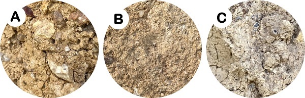
A ► Sable argileux : sable de couleur ocre / grain grossier / avec graviers de silex émoussés, de couleur gris.
B ► Limons : sable de grain très fin / couleur brune / pauvre en cailloux / couche compacte.
C ► Argile à silex : argile de couleur blanchâtre / grain grossier / silex entiers ou peu fragmentés, de couleur jaune à brune.

Pour loguer cette EarthCache, vous devez vous rendre aux coordonnées indiquées en Waypoint 1, et répondre aux questions suivantes :
0 ► Prenez une photo qui permet de vous identifier (visage, pseudo, GPS, etc.) devant le rempart.
1 ► Observez la coupe transversale du rempart au Waypoint 1. En vous aidant de la description, associez chaque formation géologique à chacune des couches du rempart.
Couches : 1 / 2 / 3 (telles que décrites dans la partie 2)
Formations : A / B / C (telles que décrites dans la partie 3)
2 ► Par déduction avec votre réponse à la question 1, associez ces formations à leur époque géologique :
Époques géologiques : Crétacé Supérieur / Eocène Supérieur / Quaternaire
Rappels concernant les « EarthCaches » :
Il n’y a pas de contenant à rechercher aux coordonnées, ni de carnet à signer sur place. Il suffit de se rendre sur les lieux, de répondre aux questions ci-dessus, et de nous envoyer vos propositions de réponses soit via notre profil, soit via la messagerie geocaching.com (Message Center).
Vous pouvez loguer un « Found it » sans attendre notre confirmation. Nous vous contacterons en cas de problème ou pour fournir d’éventuelles précisions.
Les « Found it » enregistrés sans envoi de réponses seront supprimés.

► The series ◄
Amboise is a town located in the heart of the Loire Valley, a UNESCO World Heritage Site.
Situated at the confluence of the Loire and Amasse rivers, the development of Amboise has been strongly influenced by the local geology, from the ancient Gallo-Roman oppidum to the present day.
The [Geological Walk in Amboise] series proposes EarthCaches inviting you to discover Amboise's heritage through the nature of the building rocks, geological and hydrological phenomena.
► Part 1: The site ◄
Touraine is located in the southwestern part of the vast geological complex of the Paris Basin, which is characterized by the exclusive presence of sedimentary rocks. Over hundreds of millions of years, the soil has been built up by stacking layers of rock.
As it flowed, the waters of the Loire dug into its bed, penetrating the various layers of soil. This erosion led to the formation of numerous cliffs along the river. The river Amasse did the same until its confluence with the Loire, forming a rocky spur: the plateau of Châtelliers. A Gallo-Roman oppidum, called Ambacia, was established at the top of this spur. This location was highly strategic, dominating the valleys by about 50 meters.
This ancient, fortified city was the capital of the Gallic Turon people, who gave their name to the region. The oppidum developed around a funerary monument, called Caesar's Mound, which occupies the very center of the plateau. This artificial mound, dating from the 5th century BC and of 6-meters high, can be seen at Waypoint 2.
A sanctuary, or fanum, comprising a temple, baths and other public buildings, was built in the 1st century AD. The foundations are still visible at Waypoint 3.
During the Iron Age, the oppidum extended over 50 hectares, being one of the largest in Gaul. An earthen rampart was built to the east, about 900 meters from the tip of the spur (Waypoint 1).
The visit to this archaeological site also provides an opportunity to look at the geological analysis of the subsoil of the plateau. After having studied these geological characteristics with this EarthCache, I invite you to go to the site to observe them in person.
► Part 2: Formation of the rampart ◄
The 800-metre-long rampart, barring the plateau, is entirely artificial: the Turons dug into the ground to form an outer ditch, and thus raised the rampart. In some places, it was up to 10 meters high and 25 meters wide: that's a lot of digging!
The rampart, or vallum, was cut through by the construction of a road in 1978, following a NE-SW axis: it is thus possible to directly observe the cut of the rampart! As this mound was raised by digging into the ground, the geological formations of the plateau can be found in the rampart, but in the opposite position to their natural position in the ground. Thus, the most recent geological formation (i.e. the first to have been dug) is found at the base of the backfilled part, while an older geological layer is found at the top.

The sedimentary base consists of Upper Turonian yellow tuff (referenced 0 on the schematic section above), not visible on site.
A precise observation of the layers forming the rampart makes it possible to deduce the geological layers (1, 2, 3) forming the Châtelliers plateau. This will be the subject of the questions asked below for the validation of the EarthCache.
► Part 3: Geological layers ◄
Here is a description of the different geological formations visible in the section of the rampart. They are indicated in no particular order: it will then be up to you to put them back into their geological order.
A ► Clayey sand: ochre colored sand / coarse grained / with blunt, grey flint gravels.
B ► Silt: very fine-grained sand / brown in color / poor in pebbles / compact layer.
C ► Flint clay: whitish clay / coarse grained / whole or slightly fragmented flints, yellow to brown.
To log in to this EarthCache, you must go to the coordinates of Waypoint 1, and answer the following questions:
0 ► Take a photo that identifies you (face, nickname, GPS, etc.) in front of the wall.
1 ► Look at the cross-section of the rampart at Waypoint 1. Using the description, associate each geological formation with each layer of the rampart.
Layers: 1 / 2 / 3 (as described in part 2)
Formations: A / B / C (as described in part 3)
2 ► By deduction with your answer to question 1, associate these formations with their geological period:
Geological periods: Upper Cretaceous / Upper Eocene / Quaternary
Reminders about the “EarthCaches”:
There is no container to look for nor a logbook to sign. Just go to the location, answer the questions above, and send us your proposals of answers either via our profile or Message Center.
You can log “Found it” without waiting for our validation. We will contact you in case of problems or to provide any clarification.
“Found it” logs saved without sending answers will be deleted.
Source :
Macaire J.-J. 2023 - Balade géologique à Amboise. Biotope, Mèze - MNHN, Paris (Collection Balades géologiques), 32 pages.