(English version below)


Répondez aux questions en observant la configuration du site et en utilisant le panneau d'information.
0 ► Prenez une photo qui permet de vous identifier (visage, pseudo, GPS, etc.) avec la table d’orientation en arrière-plan.
1 ► L'anticlinal d'Amboise est la conséquence de la formation d'une chaîne de montagnes : laquelle ?
2 ► De combien de mètres s’est élevé l’anticlinal en son centre ?
3 ► Nommez les strates géologiques entaillées par la vallée de l'Amasse.
Rappels concernant les « EarthCaches » :
Il n’y a pas de contenant à rechercher aux coordonnées, ni de carnet à signer sur place. Il suffit de se rendre sur les lieux, de répondre aux questions ci-dessus, et de nous envoyer vos propositions de réponses soit via notre profil, soit via la messagerie geocaching.com (Message Center).
Vous pouvez loguer un « Found it » sans attendre notre confirmation. Nous vous contacterons en cas de problème ou pour fournir d’éventuelles précisions.
Les « Found it » enregistrés sans envoi de réponses seront supprimés.

► Stratification :
Une stratification est un agencement en couches, ou strates, de dépôts successifs et horizontaux de sédiments. Ces couches de sédiments se déposent successivement, les unes sur les autres : les couches les plus anciennes se trouvent en-dessous, chaque couche nouvelle se posant par-dessus la précédente.
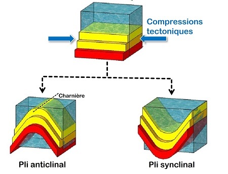
► Pli :
Un pli est une déformation des roches résultant de compressions tectoniques latérales, formant une courbure (en bosse ou en creux) par flexion des strates.
► Anticlinal et synclinal :
Un anticlinal est un pli dont la courbure est orientée vers le haut (pli en forme de bosse). Les couches plus anciennes remontent en son centre.
Un synclinal est un pli dont la courbure est orientée vers le bas (pli en forme de cuvette). Les couches plus récentes descendent en son centre.


Reply to the questions by observing the site and using the information panel.
0 ► Take a photo that identifies you (face, nickname, GPS, etc.) with the orientation table in the background.
1 ► The Amboise anticline is the consequence of the formation of a mountain chain: which one?
2 ► How many meters did the anticline rise in the center?
3 ► Name the geological strata cut by the Amasse valley.
Reminders about the “EarthCaches”:
There is no container to look for nor a logbook to sign. Just go to the location, answer the questions above, and send us your proposals of answers either via our profile or Message Center.
You can log “Found it” without waiting for our validation. We will contact you in case of problems or to provide any clarification.
“Found it” logs saved without sending answers will be deleted.

► Stratification:
Stratification is an arrangement in layers, or strata, of successive, horizontal deposits of sediment. These layers of sediment are deposited successively, one on top of the other: the oldest layers are underneath, with each new layer lying on top of the previous one.
► Fold:
A fold is a deformation of rocks resulting from lateral tectonic compressions, forming a curvature (hump or dip) by bending the strata.
► Anticline and syncline:
An anticline is a fold with an upward curvature (hump-shaped fold). Older strata rise in its center.
A syncline is a fold whose curvature is oriented downwards (bowl-shaped fold). Younger layers descend in the center.
Source :
Macaire J.-J. 2023 - Balade géologique à Amboise. Biotope, Mèze - MNHN, Paris (Collection Balades géologiques), 32 pages.