
Cette cache a été posée à l'occasion du Mega évent "Au Charbon" à Oignies GC9XH0Z. Ce rassemblement a été voulu par les organisateurs comme un moment de convivalité entre passionés de Geocaching, de nature et de patrimoine. Notre volonté est de permettre à chaque profil de joueur de pouvoir pratiquer ce loisir comme il le souhaite et de partager avec d'autres des moments de rassemblement et de partage autour d'un site emblématique du bassin minier du Pas-de-Calais : Le carreau de fosse du 9-9bis de Oignies.
En forme les terrils !
Cette Earth Cache a pour but de vous faire découvrir la forme des terrils.
C'est quoi un terril
Le terril est avant toute chose une colline artificielle construite par accumulation de résidu minier lorsque le charbon était extrait de la mine par les mineurs. Composé principalement de sous-produits de l’exploitation minière comme les schistes, les grès ou des résidus divers d'exploitation.
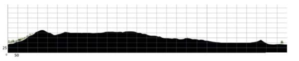
Au sein d’une plaine largement ouverte, le Bassin Minier du Nord-Pas-de-Calais s’étend sur environ 120 km, traversant les deux départements du Nord et du Pas-de-Calais. On dénombre dans le Bassin Minier du Nord-Pas-de-Calais, 340 terrils recensés à des fins d’exploitation. Ils prennent souvent des formes coniques et sont parfois désignés de terrasse ou de terril plat quand l’accumulation forme un plateau.
La forme des terrils
Il en existe quatre types.
- Les terrils plats (ou tabulaires) : ils sont très répandus au XVIIIe siècle et XIXe siècle, le déversement est fait horizontalement sur la longueur. Ils ont souvent une largeur variable. Ils peuvent également être déversés à flanc de colline.
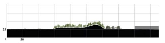
- Les terrils coniques: ces terrils sont construits par des déversement verticaux, lui donnant une forme de cône, ce type est particulièrement répandu au XXe siècle.
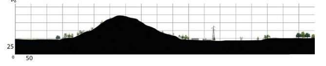
- Les terrils tronqués: ce type est identique au précédent mais avec un sommet plat.
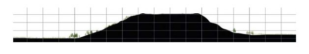
- Les terrils modernes: ils sont formés d'un ensemble de terrils coniques et sont plus massifs. Ce type est apparu avec les grandes infrastructures construites après la Seconde Guerre mondiale. Ils peuvent ressembler à des terrils plats.
Sources
Comment valider cette Earth Cache
Petit rappel concernant les "Earth Caches": il n'y a pas de contenant à rechercher, ni de logbook. Il suffit de se rendre sur les lieux, de répondre aux questions ci-dessous. Vous pouvez loger en "Found it" et envoyez-moi vos propositions de réponses, soit via mon profil, soit via la messagerie geocaching.com (Message Center), et je vous contacterai en cas de problème.
Localisation
C'est au sommet de ce terril que vous pourrez en observer d'autres. Une plaque panoramique vous aidera à identifier les terrils, et ce sont vos observations qui vous permettront de répondre aux questions.
Questions
- 1: la majorité des terrils sont de forme conique, citez en trois.
- 2: citez deux terrils coniques tronqués.
- 3: donnez le nom d'un terril plat.
- 4: une photo de vous ou d'un objet vous représentant, est obligatoire pour valider cette Earth Cache.
Merci par avance de ne pas poster de spoiler dans vos logs!
Bon Geocaching!


This cache was placed during the Mega vent "Au Charbon" in Oignies GC9XH0Z. This gathering was wanted by the organizers as a moment of conviviality between enthusiasts of geocaching, nature and heritage. The desire is to allow each profile of player to be able to practice this leisure as he wishes and to share with others moments of gathering and sharing around an emblematic site of the mining basin of Pas-de-Calais: the pit tile of 9-9bis of Oignies.
Fit for the slag heaps!
The aim of this Earth Cache is to help you discover the shape of the slag heaps.
What is a slag heap?
The slag heap is primarily an artificial hill built by the accumulation of mine waste when coal was extracted from the mine by the miners. It is mainly composed of mining by-products such as shale, sandstone or various mining residues.
The Nord-Pas-de-Calais coalfield extends over approximately 120 km, crossing the two departments of Nord and Pas-de-Calais, within a largely open plain. In the Nord-Pas-de-Calais mining basin, 340 slag heaps have been identified for mining purposes. They often take on conical shapes and are sometimes referred to as terraces or flat slag heaps when the accumulation forms a plateau.
The shape of the slag heaps
There are four types.
- Flat (or tabular) spoil heaps: these were very common in the 18th and 19th centuries, and the spoil heap is tipped horizontally along the length. They often have a variable width. They can also be dumped on the side of a hill.
- Conical spoil heaps: these spoil heaps are built by vertical tipping, giving it a conical shape, this type is particularly widespread in the 20th century.
- Truncated spoil heaps: this type is identical to the previous one but with a flat top.
- Modern spoil heaps: they are formed by a set of conical spoil heaps and are more massive. This type appeared with the large infrastructures built after the Second World War. They can look like flat heaps.
Sources
How to validate this Earth Cache
A reminder about the "Earth Caches": there is no container to look for, nor a logbook. You just have to go to the place and answer the questions below. You can log in "Found it" and send me your suggestions for answers, either via my profile, or via the geocaching.com message center, and I will contact you if there is a problem.
Location
It is at the top of this slag heap that you can observe others. A panoramic plaque will help you to identify the slag heaps, and it is your observations that will enable you to answer the questions.
Questions
- 1: the majority of spoil heaps are conical in shape, name three.
- 2: name two truncated conical tips.
- 3: give the name of a flat slag heap.
- 4: a photo of you or an object representing you is mandatory to validate this Earth Cache.
Thank you in advance for not posting spoilers in your logs!
Happy Geocaching!