DAJKI W PAKIECIE
DYKES IN SHEET

Prace terenowe bywają dla geologów trudne z różnych względów. Czasami przeszkadza głęboka woda, innym razem wysoki płot (a za nim nieraz także groźny pies). Bywa też tak, że przychodzimy do odsłonięcia, a tam po prostu niewiele widać. Niekiedy trzeba się naprawdę mocno „wgryźć” w skałę, żeby zobaczyć to, co jest do zobaczenia.
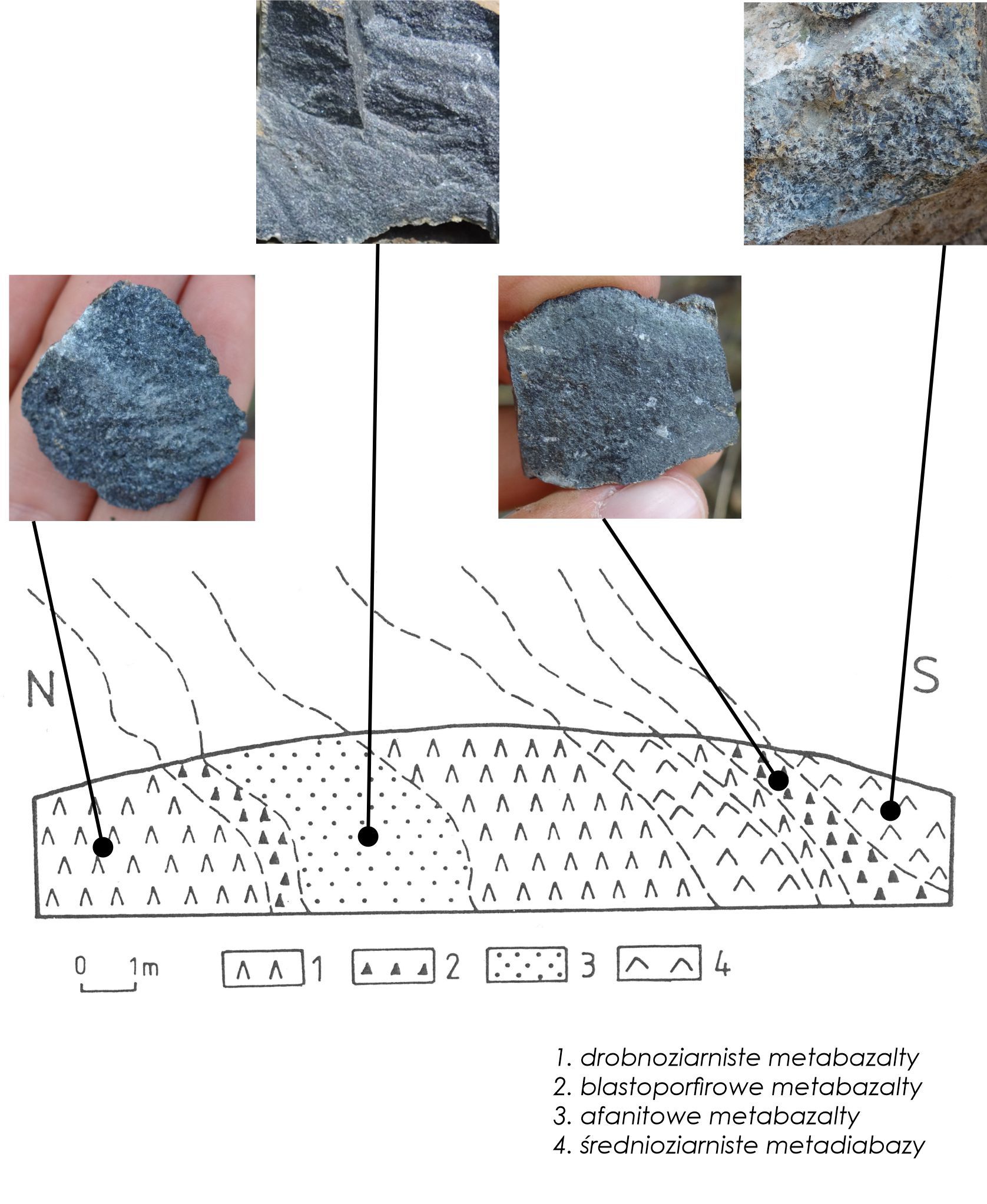
Jednym z takich miejsc są skałki w przekopie pod Wieżycą. Ich pochodzenie jest niezwykle ciekawe: widzimy tu tak zwane dajki* pakietowe. Powstały około 400 milionów lat temu, kiedy magma ze swojego źródła w ziemskim płaszczu przedzierała się ku powierzchni ówczesnego dna oceanicznego, najprawdopodobniej przemieszczając się ku górze systemem żył, które wypełniały spękania powstałe podczas rozsuwania się płyt tektonicznych. Stąd wynika zróżnicowanie skał w odkrywce. Zdajemy sobie sprawę, że różnice są subtelne, a skały są trudne do rozróżnienia – spokojnie, nie tego będziemy od Was wymagać!
Wiele lat temu (w 1994 roku) zróżnicowanie skał w przekopie przedstawił na przekroju geologicznym profesor Alfred Majerowicz, wybitny badacz Ślęży (fig. 1). Czy obecnie widać to, co dostrzegł Profesor? Nam wydaje się, że rozszyfrowaliśmy, co autor miał na myśli (fig.1 – zdjęcia skał). Ciekawe czy Wam też się to uda? Spróbujcie odpowiedzieć na pytania. Powodzenia!
Fig. 1.Przekop pod Wieżycą – przekrój geologiczny wg. A Majerowicza (1994), fot. skał M. Furca
*Dajka (żyła niezgodna) – ciało skalne powstające poprzez wtargnięcie magmy niezgodnie z układem starszych warstw skalnych
Aby zalogować EC musisz odwiedzić miejsce i przesłać odpowiedzi na pytania:
1. Czy granice między poszczególnymi rodzajami skał zaznaczone na rysunku są dobrze wyeksponowane w terenie? A może słabo albo w ogóle nie są widoczne?
2. Jaki charakter ma odsłonięcie:
a) pionowa, gładka ściana;
b) kilka pojedynczych skałek;
c) silnie spękane skały, porośnięte trawą
3. Prześlij swoje zdjęcie ze skałkami w przekopie.
UWAGA! Do zalogowania tej skrytki EarthCache wymagane jest wysłanie odpowiedzi do zadań przez profil PIG_PIB. Logować można po wysłaniu rozwiązań, nie czekając na wiadomość z naszej strony. Logi bez wysłanych odpowiedzi będą kasowane w ciągu 14 dni.

Field work can be difficult for geologists for various reasons. Sometimes deep water disturbs, other times a high fence (and sometimes also a dangerous dog behind it). It also happens that we come to the outcrop, and there is simply not much to see. Sometimes you have to really "bite" into the rock to see what there is to see.
One of such places are the rocks in the excavation under Wieżyca. Their origin is extremely interesting: we see here the so-called sheeted dykes*. They were formed about 400 million years ago, when magma from its source in the Earth's mantle forced its way to the surface of the then ocean floor, most likely moving upwards with a system of veins that filled the cracks created when the tectonic plates moved apart. Hence the diversity of the rocks in the outcrop. We realize that the differences are subtle, and the rocks are difficult to distinguish - don't worry, that's not what we will require of you!
Many years ago (in 1994) the diversity of rocks in the outcrop was presented on a geological cross-section by Professor Alfred Majerowicz, an outstanding researcher of Ślęża (fig. 1). Can you now see what the Professor noticed? It seems to us that we have deciphered what the author had in mind (fig.1 - photos of rocks). We wonder if you can do it too? Try to answer the questions. Good luck!
*Dyke (incompatible vein) - a rock body formed by the intrusion of magma discordant with the older rock layers
To log the EC you need to visit the place and send answers to the questions:
1. Are the boundaries between particular types of rocks marked in the drawing well exposed in the field? Or maybe they are barely visible or not visible at all?
2. What is the nature of the outcrop:
a) a vertical, smooth wall;
b) several single rocks;
c) strongly fractured rocks, overgrown with grass
3. Send your photo with the rocks in the excavation.
WARNING! To log this EC you have to send the answers to PIG_PIB profile. You can log after sending the answers, without waiting for our reply. Logs without answers will be deleted within 14 days!
Literatura / References:
Majerowicz A. (1994) Tekstural features and symptoms of ocean floor metamorphism in the top part of the Ślęża Ophiolite (SW Poland). Archiwum mineralogiczne. T.1, z.2
Grafika w tle / Background graphics: Pixabay.com