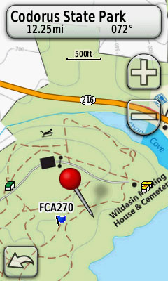
This multi-cache is located in the Codorus State Park. The first step takes you to the Wildasin Meeting House and the grave of Oswald Dubs, a Revolutionary Soldier. The second step takes you to the actual cache.
Parking:
The nearest parking is N39 47.200 W 76 55.920. It is a 15 minute walk to the meeting house.
Garmin Custom Maps for Oregon, Dakota, and Colorado models
 Here is a downlad link to Garmin Custom Maps of Codorus State park for your Garmin GPS. Your GPS must be a Oregon, Dakota or Colorado model or have custom map capability.
Click here for tips on installing Garmin Custom Maps
Printable Trail Maps
Click Here to obtain a trail map of the area. (642k) It may take a while to download.
Caution During Hunting Season/ Snow Cover
This area is open to mountain bikes all year long and hunters. Big Game rifle hunting season starts the Monday after Thanksgiving and continues for two to three weeks. It is not recommended that you attempt to find this cache during that time except on Sundays. If you insist on finding the cache during hunting season, then wear Orange for safety. I do NOT recommend that you visit this cache during Deer Hunting Season except on Sundays. This cache may be very difficult to find when the ground is covered in snow.
Step 1: The Wildasin House and the Grave Site
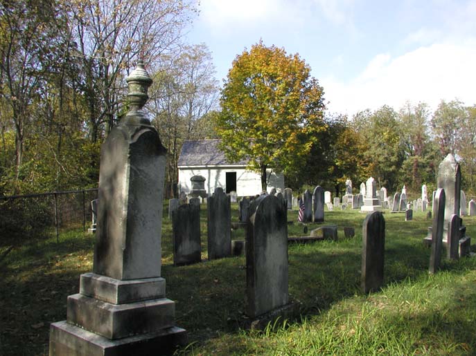
The following coordinates (N39 47.292 W76 55.295) takes you to the grave site of Oswald Dubs who served in the American Revolution War. His grave is marked with a bronze plaque. As you enter the graveyard, you will pass the Wildasin Meeting House. The door to the meeting house is normally open. Feel free to investigate the inside.
Answer the following questions to obtain the coordinates for the actual cache.
- E = Based on the information on the bronze grave marker, what year was Oswald Dubs enlisted in the American Revolutionary War?
- C = Looking at the cornerstone of the Wildasin Meeting House, what is the year the Wildasin Meeting House was erected?
Now do some math to obtain the decimal portion of the coordinates to the actual cache.
Actual Cache Coordinates: N39 47.d W76.55.x
- d = 1973 minus E (from question 1)
- x = C minus 1266 (from question 2)
The actual cache is located at following coordinates N39 47.d W76.55.x.
You may get a weak signal in the summer and fall seasons since the cache is in a grove of trees. Trail suggestion from Stage 1 to Stage 2: Take the A2 trail southwest, then follow trail 2 when it splits off.
History of the Wildasin Meeting House
(The following was excerpted from "History of St. Paul's (Dub's) Church, 1853-1999")
 Around 1829, the inhabitants of Heidelberg Township in York County, Pennsylvania began to feel the need for community worship and a public burial ground. Prior to 1829 there was located on a knoll along a private road or path joining the present Hanover-Glen Rock Highway with the Black Rock Road a private burial ground known as Wildasin's Graveyard. Since then a frame building has been erected and the area used for public school, worship and burial.
The adjoining farm from which it gets its name was tenanted by Richard Bankert, a descendant of the original Wildasin family, until the existence of Codorus State Park. It was first used for a burial ground by George and Magdalena Wildasin and their family. On September 9, 1829, Maxwell McMaster and Daniel Dubs, Jr., both of Manheim Township, bought the burial ground of 40 perches for $1.00 to be used as a public burial ground. It is stated in the deed that it was made public because "private graveyards decay and grow wild through inattention and negligence of posterity". Apparently the Wildasins permitted people of the community other than their own family to use this graveyard, even before it was made public. It is also stated in the deed that strangers who might die in the vicinity and have no means for burial would be buried free and all others were to pay not more than $1.00 for the right of burial and maintenance to the original buyers, who became the first trustees. On January 23, 1841, these trustees bought an additional 20 perches from George and Magdalena Wildasin, also for $1.00, for the purpose of erecting a house of public worship and a school house. It is presumed that the building, still standing in a fine state of repair, was built during the year 1841. All evidence indicates that services were conducted for Lutheran, Reformed and Brethren people of the community following its erection and continued under the guidance of the two original trustees until April 2, 1847, when the first election of trustees was held.
Then three trustees, representing each of the forenamed congregations, were elected: Maxwell McMaster, 1 year, Brethren; Daniel Dubs, 2 years, Reformed; and George Wildasin, 3 years, Lutheran. As these terms expired, they were elected for a term of three years. The trustees, three in number, will always be taken out of the three denominations, namely Lutheran, German Reformed and Baptist (Brethren).
Pastors from both St. Matthew's Lutheran Church and Emmanuel's Reformed Church, both located in Hanover, preached at the school house.
The oldest stone in the burial ground is that of Oswald Dubs, who died May 31, 1782. While the Lutherans and Reformed built a church (St. Paul's, or Dubs, Union Church), the Brethren continued to use the Meeting House at least annually until World War II, when services were discontinued due to the gas shortage. The descendants of this Brethren group now worship in Pleasant Hill Church from which congregation a trustee is provided.
On April 29, 1889, a third parcel of 41-1/2 perches of land to enlarge the graveyard was bought from John M. Wildasin and wife Lydia for $25.00.
Photos of Visitors and News Article
Read "The Evening Sun" article about Geocaching which features Zinnware at the Wildasin Meeting House Cache. Click here to see photos of visitors from 10/30/2002 through 7/25/2003.
Click here to see photos of visitors from 11/1/2003 through 8/28/2004.
Click here to see photos of visitors from 12/18/2004 through 9/5/2005.