
Cette cache a été posée à l'occasion du Mega évent "Au Charbon" à Oignies GC9XH0Z. Ce rassemblement a été voulu par les organisateurs comme un moment de convivalité entre passionés de Geocaching, de nature et de patrimoine. Notre volonté est de permettre à chaque profil de joueur de pouvoir pratiquer ce loisir comme il le souhaite et de partager avec d'autres des moments de rassemblement et de partage autour d'un site emblématique du bassin minier du Pas-de-Calais : Le carreau de fosse du 9-9bis de Oignies.
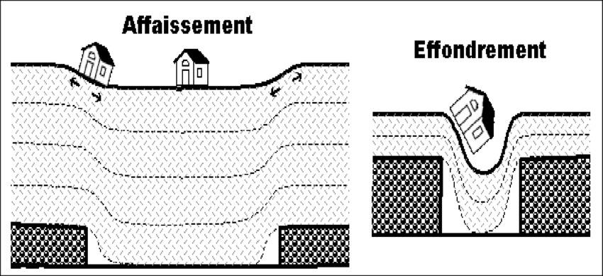
Affaissement ou effondrement ?
[ENGLISH BELOW]
L’exploitation minière a profondément modifié l’hydrographie du Bassin minier et a introduit un nouvel élément structurant dans le paysage : les étangs. Les étangs existaient déjà dans le paysage artésien avant l'exploitation des mines mais les mines ont profondément modifié le paysage a ce point de vue.
Deux phénomènes peuvent être à l’origine de leur apparition.
- Dans le premier cas, notamment dans les zones à l’origine marécageuses, le sol est fragilisé par les galeries d’exploitation en sous-sol et s’affaisse progressivement. Les eaux du fond, cessant d’être pompées à l’arrêt de l’exploitation, remontent à la surface et finissent par donner naissance à une étendue d’eau comme la Mare à Goriaux à Raismes et à Wallers.
- Autre cas de figure, l’étang naît de l’enfoncement progressif d’un terril provoquant la remontée de la nappe phréatique, comme pour l’étang des Argales à Rieulay. La plupart des étangs d’affaissement ont été aménagés et sont aujourd’hui des bases de loisirs très appréciées. Certains autres sont des reserves de biodiversités fermées au public.
Les questions:
1 Quel élément massif présent dans le paysage a ici pu influencer le faciès et provoquer la formation de cet étang ?
2 Quel élément invisible ici également crée par l'homme à partir de la "révolution industrielle" a pu modifier le faciès ici?
3 D'après le descriptif et vos observations diriez-vous que vous êtes face a un éffondrement ou un affaissement ?
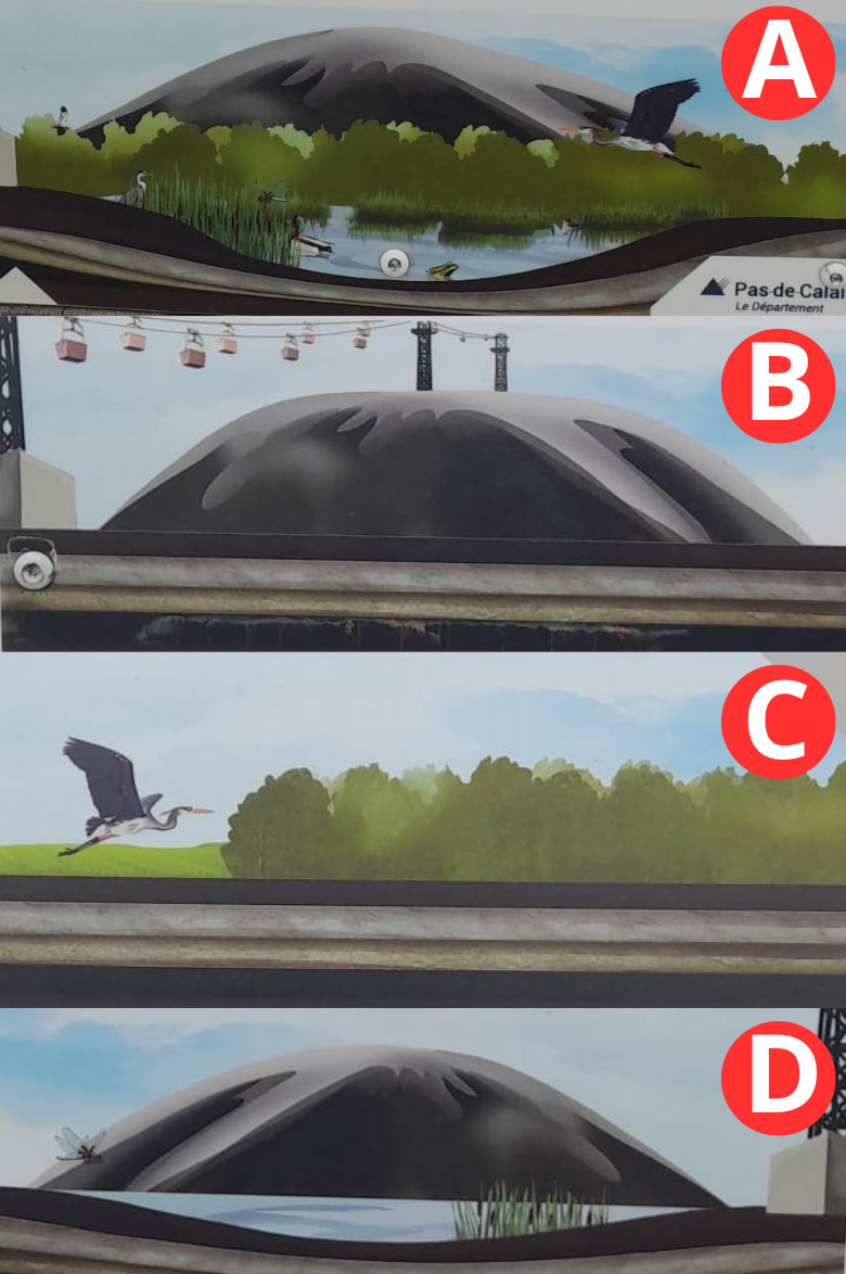
4 Replacez dans l'ordre les lettres du document ci-dessous afin de reconstituer l'évolution du paysage.
5 Prenez une photo de vous ou d'un objet ou de votre pseudo permettant de vous identifier sur place.
Loguez cette cache "Found it" et envoyez-moi vos propositions de réponses soit via mon profil, soit via la messagerie geocaching.com (Message Center), et je vous contacterai en cas de problème


Subsidence or collapse ?
Mining has profoundly changed the hydrography of the mining basin and introduced a new structuring element into the landscape: the ponds. The ponds already existed in the artesian landscape before the exploitation of the mines but the mines profoundly modified the landscape from this point of view.

Two phenomena can be at the origin of their appearance.

- In the first case, particularly in the originally marshy areas, the ground is weakened by the mining galleries in the basement and gradually subsides. The water from the bottom, ceasing to be pumped out when mining stops, rises to the surface and ends up giving rise to a body of water like the Mare à Goriaux in Raismes and Wallers.

- In another scenario, the pond arises from the gradual sinking of a slag heap causing the water table to rise, as for the Argales pond in Rieulay. Most of the subsidence ponds have been developed and are now popular recreational bases. Some others are biodiversity reserves closed to the public.
The questions:
1 What massive element present in the landscape could have influenced the facies here and caused the formation of this pond?

2 What invisible element here also created by man from the "industrial revolution" could have modified the facies here?

3 Based on the description and your observations would you say that you are facing a collapse or subsidence?

4 Put the letters of the document below in order to reconstruct the evolution of the landscape.

5 Take a photo of yourself or of an object or your nickname to identify you on the spot.

Log this cache "Found it" and send me your proposed answers either via my profile or via geocaching.com messaging (Message Center), and I will contact you if there is a problem.