
A Earthcache resulta da relação multidisciplinar entre a Geologia e a Geografia e tem como tema a Geomorfologia litoral, especificamente do Concelho de Sintra. As coordenadas sugeridas são epicentros de cenários geomorfológicos costeiros típicos do sistema de arribas no concelho. Uns com horizonte de observação mais abrangente, outros menos. Uns que combinam vários cenários distintos e outros menos.
A Earthcache propõe 4 locais distintos de observação, cada um deles, de per si, constitui uma alternativa onde podes efetuar as tuas observações e assinalar o found na E.C.
Esses locais são os seguintes:
N 38° 46.725' W 9° 29.881' - GZ1 - CABO DA ROCA
N 38° 49.063' W 9° 28.498' - GZ2 – PRAIA GRANDE
N 38° 50.180' W 9° 27.980' - GZ3 – AZENHAS DO MAR
N 38° 51.993' W 9° 27.050' - GZ4 – PRAIA DO MAGOITO
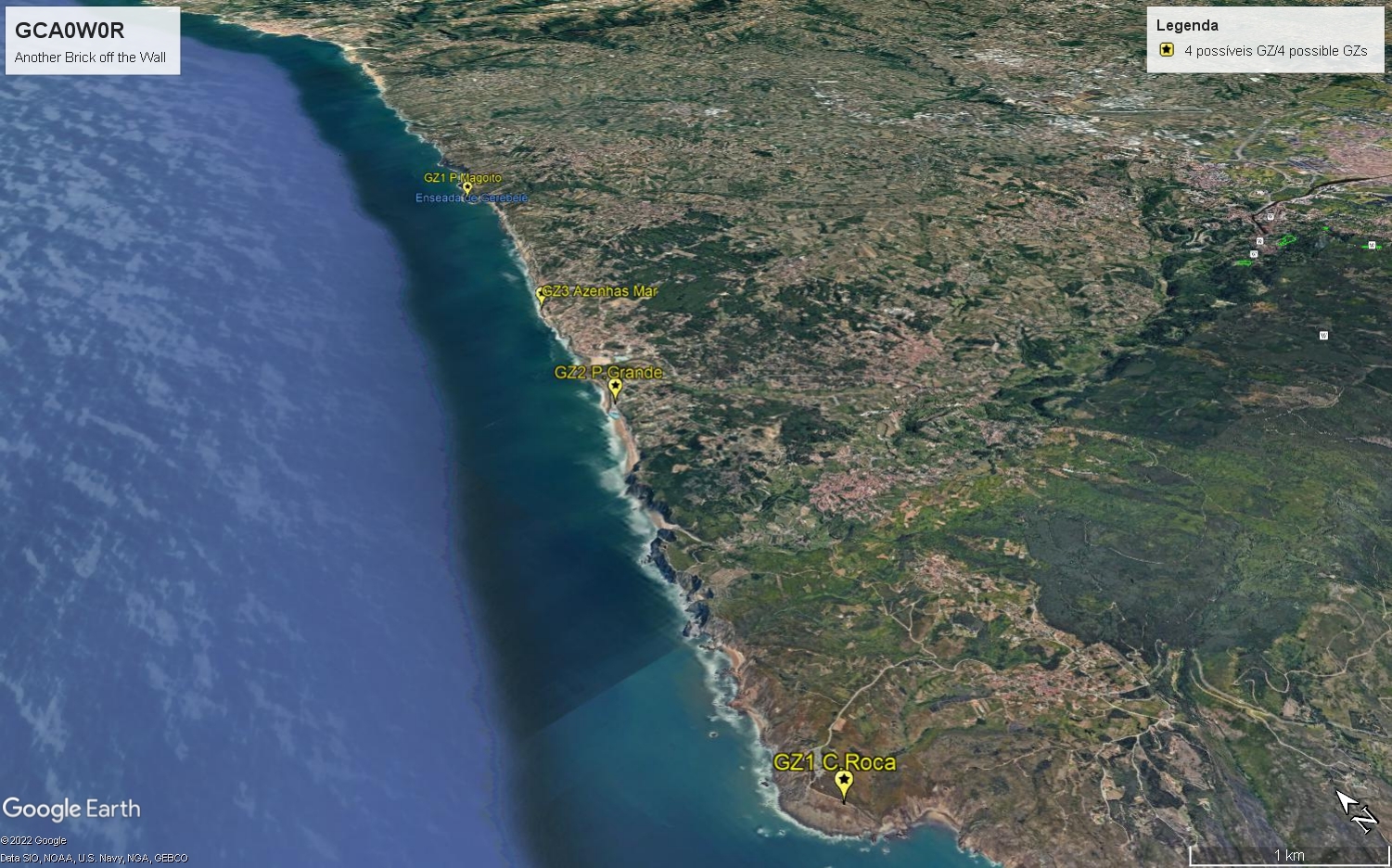
Nota: todos os GZs encontram-se assinalados com Waypoints que sugiro consultares para informações adicionais que ajudarão nas observações.
A tua tarefa será bem sucedida com o envio das 2 respostas abaixo via mail do meu perfil onde deverás indicar o GZ visitado. Como tarefa complementar para que o teu log seja deferido, terás de anexar uma foto atualizada que dê conta, de forma inequívoca, do teu trabalho de campo:
Verifica abaixo a legenda relativa aos subsistemas com arriba que constam na listing:
Am = Arriba mergulhante (img1 listing)
Ab = Arriba com base coberta por blocos (img2 listing)
Ps = Plataforma de sopé (img3 listing)
Pra A = Praia alongada e estreita – arriba (img4 listing)
Pra A (i) = Praia alongada e estreita – arriba inativa (img5 listing)
Pre A = Praia encastrada – arriba (img6 listing)
P1.Sendo este local um sistema com arriba, que tipo(s) de subsistema(s) consegues identificar? (nomeia-o pela sigla se isolado ou pelo conjunto de siglas se combinado, por exemplo (Am) ou (Pra A + Ab + ...).
P2. Em poucas palavras quais os argumentos que sustentam a tua escolha?
........./........
Geomorfologia do litoral Sintrense - sistema com Arribas (breve síntese)
A geomorfologia costeira é palco de uma forte dinâmica que configura uma diversidade de cenários. Estes variam em função da tectónica, das litologias presentes (tipo de rocha) e da maior ou menor sujeição aos mecanismos de erosão que nas zonas costeiras se manifestam sobre as mais diversas formas combinadas: erosão fluvial, pluvial, eólica e hidráulica, graças ao poder destrutivo das ondas. São, pois cenários caóticos em que o famoso refrão "Another Brick (in) The Wall" está absolutamente discordante.
Dada a diversidade de causas que contribuem para tão diversas ocorrências houve a necessidade de proceder a uma classificação mais detalhada. Esse esforço resultou na formulação de dois indicadores designados por Sistemas com arribas e Sistemas sem Arribas (NEVES, 2006). Estes últimos, por estarem associados a praias não adjacentes a arribas, não são objeto desta Earthcache.
Despacho nº 12/2010 – Definição de ARRIBA:
“vertente costeira abrupta ou com declive elevado, em regra talhada em materiais coerentes pela ação conjunta dos agentes morfogénicos marinhos, continentais e biológicos, podendo ser alcantilada se a inclinação exceder os 50% e não alcantilada se a sua inclinação for inferior a esse valor.”
Segundo as fontes citadas, dentro dos sistemas com arribas, distinguem-se 6 subsistemas que caracterizam a geomorfologia do litoral Sintrense:
Arriba mergulhante, sempre que a base da arriba se encontre permanentemente submersa, independentemente do ciclo das marés, isto é, sem qualquer plataforma costeira associada, estamos perante uma arriba mergulhante.
Arriba com base coberta por blocos, sempre que há sectores de arriba em plataformas rochosas de sopé e que, por mecanismos associados a depósito de vertente, a base se encontre coberta por blocos rochosos.
Plataforma de sopé - Arriba, em média são plataformas com largura superior a 25 mt e comprimento superior a 100mts, e deverão estar sempre associadas a uma arriba. Também poderão apresentar-se ligeiramente basculhadas (inclinadas). A sua evolução decorre de erosão diferencial, em que os afloramentos de topo são constituídos por camadas sedimentares brandas compostas por margas e argilas, enquanto que os afloramentos de base são mais resistentes como os calcários, calcários margosos ou arenito. A erosão, principalmente a ondulação, promove o recuo da arriba mais rapidamente nos sectores onde os sedimentos são mais brandos, isto é, no topo. Deste facto advém a exposição da bancada resistente do sopé, que vai constituir uma plataforma rochosa de sopé que surge descaída em relação à cota dos sedimentos subjacentes, formando um socalco ou um degrau.
Praia alongada e estreita – arriba, a sua configuração é sempre com geometria longitudinal em que o comprimento é superior à largura. Resultam da alternância de uma faixa de rochas brandas e de uma faixa de rochas resistentes. Estas últimas formam a arriba propriamente dita e constituem o seu limite interior já que a sua natureza menos friável, mais resistente, impede o desenvolvimento da praia para montante impedindo o seu alargamento.
Praia alongada e estreita – arriba inativa, de forma geral uma arriba inativa, ou arriba fóssil, é aquela cujo recuo já não permite a sua afetação pela energia do mar e consequente desbaste por essa via. Tal como no subsistema de praia alongada e estreita – Arriba, sempre que a jusante se encontra uma camada friável e a montante uma camada mais resistente, a erosão dessas camadas mais friáveis criará também uma praia alongada e estreita. A diferença é que, neste caso, o seu recuo foi de tal ordem que tornou a arriba inativa.
Praia Encastrada - arriba, são geralmente pequenas praias, de forma semicircular que se encaixam entre duas saliências rochosas protuberantes mais resistentes e que aproveitam um sector de terreno intermédio mais brando, que se vai alongando para o interior da arriba, onde se instalam. Os paredões laterais normalmente associados a estas praias funcionam como amortecedor da energia das ondas e favorecem a deposição de areias nesse setor intermédio.
Fontes:
Estudo Morfodinâmico e Sedimentar das Praias do Concelho de Sintra, https://repositorio.ul.pt/bitstream/10451/3310/1/ulfc055508_tm_ligia_oliveira.pdf

The Earthcache is based on an approach between Geology and Geography and verses Coastal Geomorphology in Sintra municipality. All the suggested coordinates are the epicentre of coastal morphologic setups included in the category of sea cliffs. Some of this scenario have a broader horizon, some not. Some combine different types or Cliff subsystems, some others, not quite.
From the proposed 4 locations you are free to choose which one is more convenient for your observations. The visit to any of this location makes you eligible to successful log the Earthcache.
Please check location list below:
N 38° 46.725' W 9° 29.881' - GZ1 - CABO DA ROCA
N 38° 49.063' W 9° 28.498' - GZ2 – PRAIA GRANDE
N 38° 50.180' W 9° 27.980' - GZ3 – AZENHAS DO MAR
N 38° 51.993' W 9° 27.050' - GZ4 – PRAIA DO MAGOITO
Please check the waypoints in the listing for addtional information that will help you in your field observations.
To be successful in your task and found you ought to reply to the two questions via mail from my profile informing the GZ that you visited. Also take into account that as a complementary task, you must attach a photo to your log that provides unequivocal proof of your fieldwork at the chosen location.
Please check carefully the acronyms for Sea Cliff subsystems described in the listing:
Pc = Plunging sea cliff (img1 listing)
Cb = Cliff with base covered with blocks (img2 listing)
Wp = Wave cut platform (img3 listing)
Enb (a) = Elongated, narrow beach, active cliff (img4 listing)
Enb (i) = Elongated, narrow beach, inactive cliff (img5 listing)
Bi = Built-in beach (img6 listing)
Q1. Being this scenario a Sea Cliff system, what type of subsystem(s) can you identify? (name it by the acronym if isolated or acronyms if combined: for example (Pc) or (Wp + Lnb (a) + …).
Q2. In few words, explain the arguments that support your choice?
Coastal geomorphology of Sintra - Sea Cliff System:
Depending on some variables such as tectonic, different lithologies (different kinds of rock), and the lesser or greater disposition to the erosion mechanisms that often occur combined: fluvial erosion, rain erosion, eolic and hydraulic erosion (as the energy of the waves acts as a hammer pounding the cliffs), altogether this are variables that define coastal geomorphology as a stage for strong dynamics which configures different chaotic geo scenarios. So, as a reverse methaphor of the famous lyrics "Another Brick (in) the wall", this is quite the opposite!
Such diversity of causes for such diversity of effects could not be neglected. Therefore, an empiric local effort resulted in the construction of two theoretical analytical indicators described as Sea Cliff Systems and Sea Beach Systems. The later, not associated to a sea cliff is not the object of this Earthcache.
"In geography and geology, a cliff is an area of rock which has a general angle defined by the vertical, or nearly vertical. Cliffs are formed by the processes of weathering and erosion, with the effect of gravity." In: wikipedia
According to the case study cited sources, within the Sea Cliff System there are 6 subsystems that characterize the geomorphology of the coast of Sintra:
Plunging Sea Cliff, Whenever the base of the cliff is permanently submerged, regardless of the tydal cycle, that is, without any associated coastal platform.
Cliff with base covered with blocks, whenever there are sectors of the cliff on rocky platforms that, due to slope deposit, the base is covered with blocks.
Wave cut platform, in average this platforms are greater than 25mt and a lenght greater than 100mt and must be always associated to a cliff. The platform may also be slightly tilted. Their morphology is due to differential erosion in which the top outcropss are made of less resistent layers such as marls and clays, while the base outcrops are built in more resistant layers such limestones, marly limestones or sandstone. Erosion, mainly swell, promotes the retreat of the cliff more quickly in the sectors where sediments are softer, that is, at the top. Consequentlty, this results on the exposure of the resistant bench at the base. It will appear as a base rocky platform, fell off in relation to the adjacent sediments forming a terrace or step.
Enlongated narrow beach - with adjacent cliff, its configuration is always with longitudinal geometry in which the length is greater than the width. They result from the alternation of bands of soft rocks and a band of resistant rock. The latter form the cliff itself and works as a barrier for further inner expansion of the beach.
Enlongated narrow beach - inactive cliff, first of all we should define an inactive cliff as a cliff that was for long exposed to the hydraulic erosion of the waves in such a way that its retreat no longer expose it to the destructive energy of the sea. As in the elongated and narow beach system with cliff, they also have narrow and long geometry, but with the significant difference of being an inactive cliff.
Built-in beach – cliff, generally this are small, semi-circular shaped beaches that fit between two side more resistant protruding rock ledges and that take advantage of a softer intermediate terrain sector which extends towards the interior of the cliff, where they settle. The side walls normally associated with these beaches act as a buffer for wave energy and favour the deposition of sand in this intermediate sector.
Sources:
Estudo Morfodinâmico e Sedimentar das Praias do Concelho de Sintra, https://repositorio.ul.pt/bitstream/10451/3310/1/ulfc055508_tm_ligia_oliveira.pdf (Beaches of Sintra Municipality, Morphodynamic and Sedimentar Case Study (only available in Portuguese language)
https://en.wikipedia.org