Particularité du canal de Bourgogne (FR)
Le canal de Bourgogne est une voie d'eau à petit gabarit (Gabarit Freycinet) située dans la région Bourgogne-Franche-Comté, qui relie l'Yonne (bassin Seine) à la Saône (bassin Rhône) sur 242 km de long, de Migennes à Saint-Jean-de-Losne.
Inauguré en 1832, il comporte 189 écluses ainsi qu’un long tunnel (3,3 km) à Pouilly-en-Auxois (sous la ligne de partage des eaux). Les écluses coté Yonne sont numérotées « xx Y », et celle coté Saône dont numérotées « xx S ».
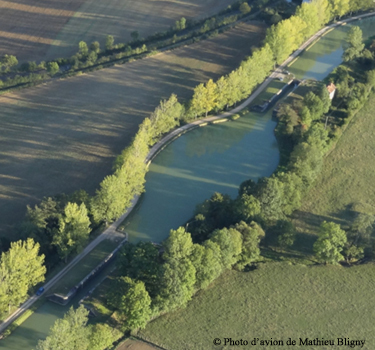
La particularité liée à cette cache est visible entre l’écluse « 49 Y » et « 48 Y » (voir le Waypoint : Point de référence), vous remarquerez une forme particulière du canal : une forme ovale !!!
Est-ce un port ou une halte ? ou même un lieu de retournement ?
Du fait du port de Pouillenay (avec tous ses avantages) non loin de ce lieu, la possibilité d’un port ou d’une halte est peu envisageable, de plus avec les bords arrondis de ce plan d’eau (pas pratique). Lieu de retournement, pour les petits bateaux actuels, certes c’est possible ; mais pour les péniches de l’époque, c’est trop risqué.
Après diverses recherches, voici l’explication que j’ai trouvée : Il fallait construire là un bief très court. Si cette longueur entre deux écluses est trop faible, l'eau lâchée par l'éclusage d'un bateau en amont ne peut être absorbée qu'en augmentant la largeur du canal, et la forme ovoïde en est la solution la plus élégante, fréquemment utilisée sur les canaux antérieurs au Bourgogne : Midi, Centre (extrait du bulletin de la « Société des Sciences de Semur-en-Auxois » au titre de 2012 (page 41 : notes de bas de page) texte de Jean-François Bligny, président de cette Société Savante).
En effet, l’espacement entre deux écluses (Bief) est lié au dénivelé du terrain (important dans cette zone), d’où non modifiable ; la quantité d’eau lâchée par une écluse est une donnée physique, la solution est alors d’élargir le canal d’où cette forme très particulière pour ce bief (la possibilité de l’élargissement simple du canal a été utilisée à d’autres endroits de ce même canal, mais pour des longueurs quasi identiques ou légèrement supérieures à ce bief, ou alors avec une autre possibilité : la possibilité de garage des embarcations (pour argumenter, voir entre les écluses « 1 Y » à « 6 Y », « 25 Y » et « 26 Y », « 36 Y » et « 37 Y »)).
Special feature of the Burgundy Canal (GB)
The Burgundy Canal is a narrow-gauge waterway (Gabarit Freycinet) located in the Bourgogne-Franche-Comté region, which connects the Yonne (Seine basin) to the Saône (Rhône basin) over 242 km in length, from Migennes to Saint-Jean-de-Losne.
Inaugurated in 1832, it has 189 locks as well as a long tunnel (3.3 km) at Pouilly-en-Auxois (under the watershed line). The locks on the Yonne side are numbered « xx Y », and those on the Saône side are numbered « xx S ».
The particularity linked to this cache is visible between the lock « 49 Y » and « 48 Y » (see the Waypoint: Reference point), you will notice a particular shape of the channel : an oval shape !!!
Is it a port or a stopover ? or even a place of reversal ?
Due to the port of Pouillenay (with all its advantages) not far from this place, the possibility of a port or a stopover is hardly possible, moreover with the rounded edges of this body of water (not practical). Place of reversal, for the current small boats, certainly it is possible; but for the barges of the time, it is too risky.
After various searches, here is the explanation that I found : A very short reach had to be built there. If this length between two locks is too small, the water released by the lock of a boat upstream can only be absorbed by increasing the width of the channel, and the ovoid shape is the most elegant solution, frequently used on the canals prior to Burgundy: Midi, Center (excerpt from the bulletin of the « Société des Sciences de Semur-en-Auxois » for 2012 (page 41 : footnotes) text by Jean-François Bligny, president of this Learned Society).
Indeed, the spacing between two locks (Reach) is linked to the difference in level of the terrain (significant in this area), hence cannot be modified; the quantity of water released by a lock is a physical given, the solution is then to widen the channel from where this very particular form for this reach (the possibility of the simple widening of the channel was used in other places of this same canal, but for almost identical lengths or slightly greater than this reach, or with another possibility: the possibility of parking boats (to argue, see between locks "1 Y" to "6 Y", “25 A” and “26 A”, “36 A” and “37 A”)).