

Un peu de géologie:
Hyères, Giens et les îles correspondent à un bâti géologique varié dont on peut lire l'histoire à travers les pierres et les paysages, de 500 millions d'années à nos jours. Sur les trois chaînes qui se sont formées lors de l'affrontement de plaques continentales en Europe, les deux dernières sont présentes dans la commune : la chaîne hercygnienne (320-300 Ma) et la chaîne alpine (70-30 Ma).
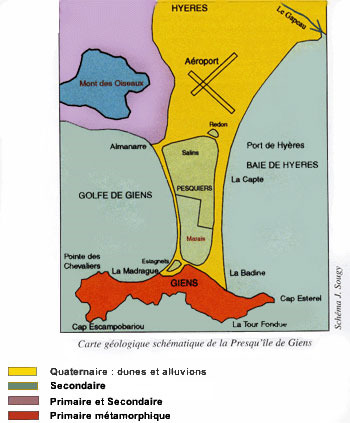

Hyères se situe à la limite de la Provence cristalline et de la Provence calcaire (et argileuse).
Nous nous interesserons içi à la provence cristalline.
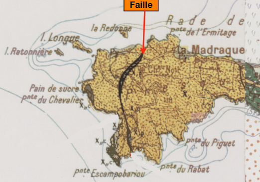
D'âge primaire, est constituée de sédiments formés entre 500 et 350 Ma, ensuite enfouis, métamorphisés et fortement déformés vers 320 Ma lors de l'élaboration de la chaîne hercynienne. Elle constitue tout le Massif des Maures dont la terminaison ouest se situe justement dans la commune, au Château de Hyères, au Fenouillet et dans les Maurettes. On retrouve ses schistes et ses quartzites à Giens et dans l'ensemble des îles. Les quartzites du Fenouillet et ceux identiques du cap des Mèdes à Porquerolles constituent de vives arêtes dans le paysage. Les seuls fossiles primaires des Maures (430 Ma) ont été trouvés au Fenouillet. À Giens les plis complexes dus aux déformations hercyniennes, repliés plusieurs fois, sont spectaculaires pour ceux qui savent les voir… ou se les faire montrer.
Nature des roches:
La presqu'ile de Giens appartient à l'unité occidentale des Maures. Les roches y sont principalement des phyllades : schistes faiblement métamorphiques riches en séricite, chlorite, alternant avec des lits quartzeux. De très nombreux plis sont observables.
La présence de plans de stratifications encore visibles mais déformés atteste de l'origine sédimentaire des roches. Il s'agit d'une alternance de sédiments fins : argilites et sables siliceux. Cette alternance est attribuée à une sédimentation rythmique de type turbidites.
Dans ces roches, la séricite remplace les argilites et les grains de quartz se substituant au sable donnent naissance à des lits de quartzites. Ces minéraux caractérisent un métamorphisme de faible intensité (zone à chlorite).

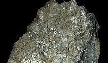

Chlorite Séricite Quartz
Pour valider la Earthcache:
Loguez cette cache "Found it" et envoyez-moi vos propositions de réponses soit via mon profil, soit via la messagerie geocaching.com (Message Center), et je vous contacterai en cas de problème.
La cotation terrain est de 5 car l'accès est possible par la mer. Cependant vous pouvez y descendre par les escaliers du phare mais attention, c'est très escarpé et dangereux.
Attention aussi au mauvais temps et au vent violent qui peuvent vous compliquer la tache, ne prenez pas de risques inutiles.
Les logs enregistrés sans réponses seront supprimés.
Rappel concernant les Earthcaches: Il n'y a pas de conteneur à rechercher ni de logbook à renseigner. Il suffit de se rendre sur les lieux, de répondre aux questions et de me renvoyer les réponses.
Merci d'ajouter à votre log une photo de vous, de votre GPS ou de votre pseudo au waypoint de la cache (OPTION).
Etude générale:
Question 1: La chaîne hercynienne prit forme il y a 320 Ma, quel est le nom du massif engendré par sa transformation.
Où se termine ce massif coté occidental?
Question 2: Quelles type de roches y sont principalement présents? Donnez les différents éléments la constituant.
Etude terrain:
Question 3: Au WP vous trouverez un filon sur le versant Est, près de la grotte marine.
Quelle est la nature de cette roche?, (duretée, couleur, etc...) Nommer-la.
D'après vous comment le filon a-t-il pu se former?
Bonnes recherches !!!

Hyères, Giens and the islands correspond to a varied geological structure whose history can be read through stones and landscapes, from 500 million years to the present day. On the three chains that formed during the clash of continental plates in Europe, the last two are present in the commune: the Hercygnian chain (320-300 Ma) and the Alpine chain (70-30 Ma).
Hyères is located on the edge of crystalline Provence and limestone (and clay) Provence.
We will be interested in the crystalline Provence.
Of primary age, is made up of sediments formed between 500 and 350 Ma, then buried, metamorphized and strongly deformed towards 320 Ma during the development of the Hercynian chain. It constitutes the whole Massif des Maures whose western termination is located precisely in the commune, at the Château de Hyères, at the Fenouillet and in the Maurettes. Its shales and quartzites are found in Giens and all the islands. The quartzites of the Fenouillet and the identical ones of the Cap des Mèdes at Porquerolles form sharp ridges in the landscape. The only primary fossils of the Moors (430 Ma) were found at Fenouillet. At Giens the complex folds due to the Hercynian deformations, folded several times, are spectacular for those who know how to see them… or have them shown.
In fact, these old sites extend to the west under the limestone Provence, gradually plunging up to 6-8 km under the Rhône and the Camargue, then reappearing in the Massif Central, ascended by a succession of faults.
Nature of the rocks:
The peninsula of Giens belongs to the western unity of the Moors. The rocks are mainly phyllades: shales weakly metamorphic rich in seriicity, chlorite, alternating with quartzel beds. Many folds are observable.
The presence of stratification planes still visible but deformed attests to the sedimentary origin of the rocks. It is an alternation of fine sediments: argillites and siliceous sands. This alternation is attributed to a turbidite-like rhythmic sedimentation.
In these rocks, the serenity replaces the argilites and the quartz grains replacing the sand give rise to beds of quartzites. These minerals characterize a low-intensity metamorphism (chlorite zone).
To validate the Earthcache:
Log this "Found it" cache and send me your response proposals either via my profile or via the geocaching.com (Message Center) mailbox, and I’ll contact you if there’s a problem.
The pitch rating is 5 because access is possible by sea. However you can go down the stairs of the lighthouse but be careful, it is very steep and dangerous.
Also watch out for bad weather and severe wind that can complicate the task, do not take unnecessary risks.
Logs saved without responses will be deleted.
Reminder concerning Earthcaches: There is no container to search or logbook to fill in. All you have to do is go to the scene, answer the questions, and return the answers to me.
Please add to your log a picture of you, your GPS or your username at the waypoint of the cache (OPTION).
General study:
Question 1: The Hercynian chain took shape 320 Ma ago, what is the name of the massif generated by its transformation.
Where does this massive western side end?
Question 2: What type of rocks are mainly present? Give the different elements that make it up.
Field study:
Question 3: At the WP you will find a vein on the east side, near the sea cave.
What is the nature of this rock? , (hardness, color, etc...) Name it.
How do you think the vein was formed?
Good research!!!