Sentier de Loupi : Cabane locale

Où sommes-nous ?
A Leffond, au coeur des Calcaires Jurassiques des plateaux de Haute-Saône.
Ce que nous dit la carte?

j 1a. Calcaires à entroques du Bajocien inférieur. Le Bajocien inférieur forme souvent les falaises constituant la limite nord des plateaux de Champlitte. Sa base, masquée par des éboulis, est rarement visible.
Les sondages effectués plus au Sud à Champlitte, Montarlot et Leffond montrent que le Bajocien débute par 1,50 m à 6 m de calcaires argileux, glauconieux et renfermant de nombreux débris de tests d'organismes
j1C. Marnes à Liostrea acuminata du Bajocien superieur
Dans sa partie inférieure, formée de calcaires argileux et de marnes grises
j 1c-2a. Calcaires oolithiques du Bajocien supérieur et du Bathonien inférieur
• Au sommet : l'Oolithe blanche du Bathonien inférieur.
Elle doit atteindre une vingtaine de mètres d'épaisseur dans la région de Champlitte. Elle débute par un niveau marneux ou marno-calcaire renfermant Terebratula ueziani (D. Contini, A. RoUet) et Plagiostoma Spa.
Ensuite, vient un ensemble homogène de calcaires gélifs en petits bancs, dans lesquels les oolithes sont dispersées dans une matrice assez fine. Dans certains bancs, les agrégats d'oolithes et de bioclastes sont affectés d'une forte compaction stylolithique

Where are we ?
In Leffond, in the heart of the Jurassic Limestones of the Haute-Saône plateaus.
What does the map tell us?
j 1a. Lower Bajocian entrochus limestones. The Lower Bajocian often forms the cliffs constituting the northern limit of the Champlitte plateaus. Its base, hidden by scree, is rarely visible.
The soundings carried out further south at Champlitte, Montarlot and Leffond show that the Bajocian begins with 1.50 m to 6 m of clayey limestone, glauconious and containing numerous remains of organism tests
j1C. Marls with Liostrea acuminata from the Upper Bajocian
In its lower part, formed of clayey limestone and gray marl
j 1c-2a. Upper Bajocian and Lower Bathonian oolitic limestones
• At the top: the Lower Bathonian White Oolite.
It must be about twenty meters thick in the Champlitte region. It begins with a marly or marl-limestone level containing Terebratula ueziani (D. Contini, A. Rouet) and Plagiostoma Spa.
Then comes a homogeneous set of frost-susceptible limestones in small beds, in which the oolites are dispersed in a fairly fine matrix. In some beds, oolite and bioclast aggregates are affected by strong stylolithic compaction
Rappel concernant les « Earthcaches »: Il n'y a pas de conteneur à rechercher ni de logbook à renseigner. Il suffit de se rendre sur les lieux et d'éxécuter les requêtes du géocacheur.
Loguez cette cache "Found it" et envoyez-moi vos propositions de réponses soit via mon profil, soit via la messagerie geocaching.com (Message Center), EN PRECISANT LE NOM ET CODE GC DE LA CACHE et je vous contacterai en cas de problème.
Il est aussi apprécié d'avoir des photos des géocacheurs sur les lieux de l''EarthCache. Sentez-vous inspiré de poster des photos de vous lors de cette visite
---
Reminder concerning "Earthcaches": there is neither a container to look for nor a logbook to sign.
Log in this cache " Found it " and send me your answers proposals or via my profile or via geocaching.com messaging (Message Center ) , BY PROVIDING THE NAME AND GC CODE OF THE CACHE and I will contact you in case of problems .
We also enjoy seeing photographs of people visiting this EarthCache. Please feel free to log photos of your visit...
Grâce à la lecture du descriptif et votre observation, répondez aux questions suivantes :
Thanks to the reading of the description and your observation, answer the following questions:
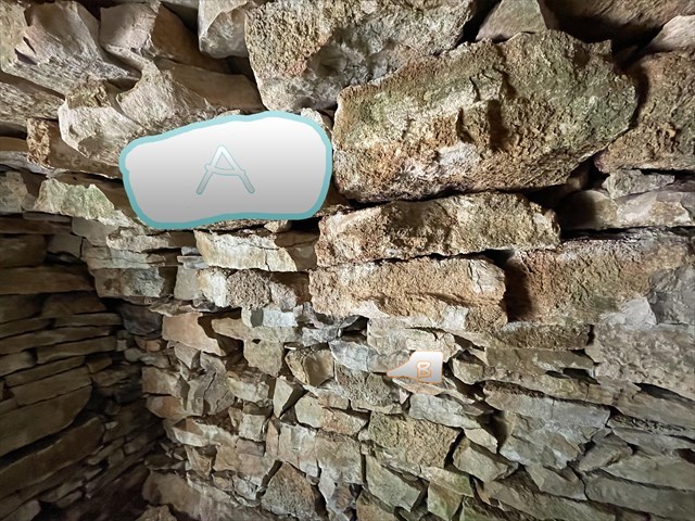
Q1 Quelle figure géologique voyez-vous sous A ? Quelle est selon vous son origine?
Q2 Décrivez ce qu'il y a sous B( au toucher, couleur, fossilifère ou non,..)
Q3 Une photo obligatoire de vous à l'exterieur de la cabane calcaire
Q1 What geological figure do you see under A? What do you think is its origin?
Q2 Describe what is under B (to the touch, color, fossiliferous or not,..)
Q3 A mandatory photo of you outside the limestone hut
JOYEUX & HAPPY EARTHCACHING !