
La Earthcache / The Earthcache
► Contexte géologique local
Du haut de 156 mètres, le Pech de Berre est un imposant éperon rocheux qui surplombe la confluence du Lot et de la Garonne.
Ce Pech est une anomalie topographique dans un environnement plat de basse altitude façonné par les lits majeurs des deux fleuves.
Cette surélévation s'explique par sa constitution stratigraphique terminale, une succession de formations du Miocène surnommée la « trilogie Aquitanienne » qui tranche avec les tendres formations sous jacentes oligo-miocènes.
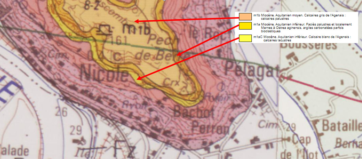
► La « Trilogie Agenaise »
Les 3 formations du Miocène formant la « trilogie Aquitanienne » sont chronologiquement :
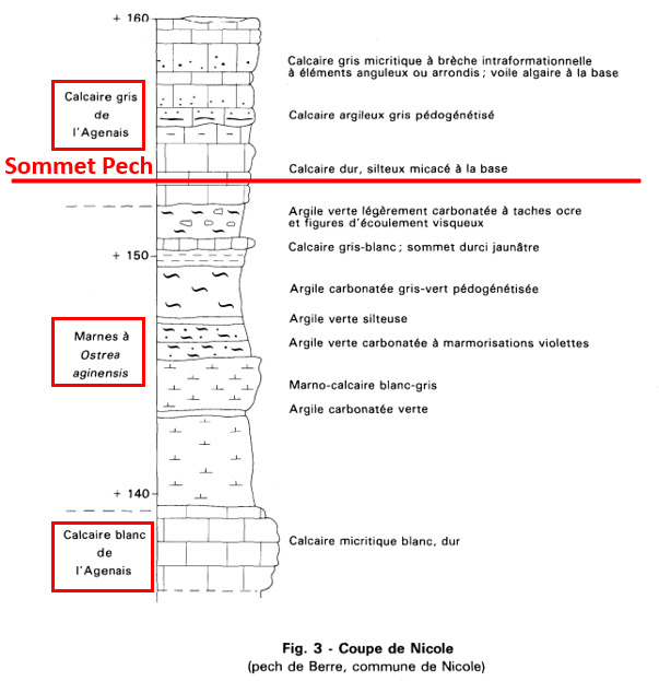
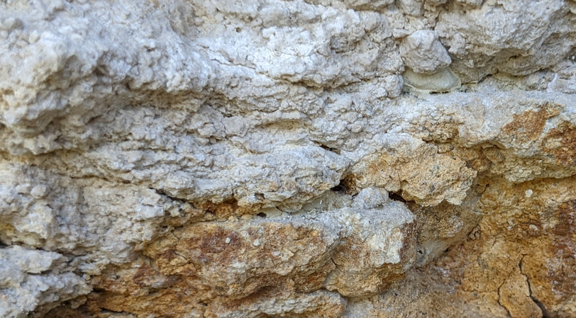
~ Le calcaire blanc de l'Agenais (Altitude : 120 et 140 m)
La formation basale présente une assise puissante de 15 à 20 m d'un calcaire lacustre mudstone de couleur claire (blanche à beige claire) avec de rares fossiles.
Il est à texture fine, tendre, et s'érode en poudre quand on le frotte avec la main.
A l'air libre il prend par endroits un coloration rouille due à l'oxydation de traces de fer.
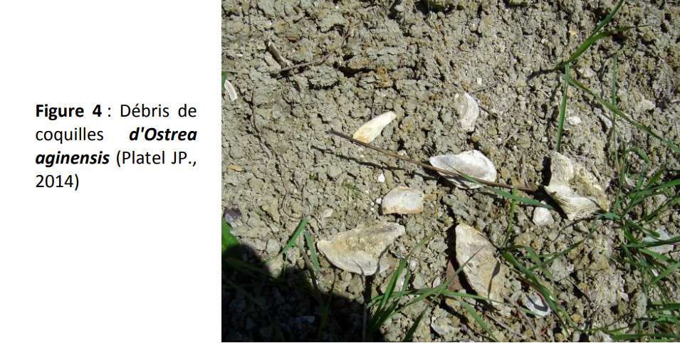
~ Les marnes à Ostrea aginensis (Altitude : 140 et 152 m)
La formation intermédiaire sont des marnes carbonatées gris-verdâtres, à texture très fine, collant aux doigts et présentant des traces de fossiles d'Ostrea aginensis (huîtres bivalves).
C'est une formation tendre qui se raye à l'ongle.
Elle reflète une petite transgression marine avec des dépôts laguno-marins.
~ Le calcaire gris de l'Agenais (Altitude : 152 et 156 m)
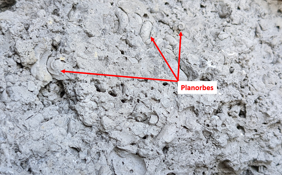
La partie sommitale, en grand partie érodée au sommet du Pech de Berre, est faite d'un calcaire lacustre gris parfois très sombre avec de nombreux moules de gastéropodes (Planorbes, Limnées).
La matière organique, abondante dans ces calcaires, lui donne souvent une odeur fétide à la cassure.
► Local geological context
From the top of 156 meters, the Pech de Berre is an imposing rocky outcrop which overlooks the confluence of the Lot and the Garonne.
This Pech is a topographic anomaly in a flat low-altitude environment shaped by the major beds of the two rivers.
This elevation is explained by its terminal stratigraphic constitution, a succession of Miocene formations nicknamed the “Aquitanian trilogy” which contrasts with the tender underlying Oligo-Miocene formations.
► The “Agenaise Trilogy”
The 3 Miocene formations forming the “Aquitanian trilogy” are chronologically:
~ The white limestone of the Agenais (Altitude: 120 and 140 m)
The basal formation has a powerful 15 to 20 m bed of a light-colored (white to light beige) lacustrine mudstone limestone with rare fossils.
It is fine-textured, tender, and erodes into a powder when rubbed with the hand.
In the open air, it takes on a rusty color in places due to the oxidation of traces of iron.
~ Ostrea aginensis marls (Altitude: 140 and 152 m)
The intermediate formation are greenish-gray carbonate marls, very fine-textured, sticky to the fingers and showing traces of fossils of Ostrea aginensis (bivalve oysters).
It is a tender formation that scratches at the fingernail.
It reflects a small marine transgression with laguno-marine deposits.
~ The gray limestone of Agenais (Altitude: 152 and 156 m)
The summit part, largely eroded at the top of the Pech de Berre, is made of a sometimes very dark gray lacustrine limestone with many gastropod molds (Planorbes, Limnée).
The organic matter, abundant in these limestones, often gives it a fetid odor when broken.
► Sources bibliographiques / Bibliographical sources
Les Questions / The Questions
Questions pour valider :"Le Pech de Berre"
Questions to validate: "The Pech of Berre"
!! NE PAS SE GARER AU POINT DE LA EARTHCACHE, c'est interdit et dangereux !!
Se garer à un des deux points de parking référencés dans les points additionnels.
!! DO NOT PARK AT THE EARTHCACHE POINT, it is prohibited and dangerous !!
Park at one of the two parking points referenced in the additional points.
Point 1 : N 44° 19.407 E 000° 20.867'
Si vous venez du parking du sommet, vous arrivez à la hauteur d'un affleurement de la falaise sur la droite - sinon c'est à gauche - photo WP1.
If you come from the parking lot at the top, you come to an outcrop of the cliff on the right - otherwise it is on the left - photo WP1.
- Question 1 : Décrivez la roche que vous avez devant vous (couleur générale, texture, dureté). Frottez-la, que se passe t-il ? Déduisez sa nature.
- Question 1: Describe the rock you have in front of you (general color, texture, hardness). Rub it, what happens? Deduce its nature.
- Question 2 : Prenez votre altitude au niveau du WP1. En considérant la coupe stratigraphique du descriptif, cette altitude est-elle cohérente avec la nature de la roche déterminée à la question 1 ?
- Question 2: Take your altitude at WP1. Considering the stratigraphic section of the description, is this altitude consistent with the nature of the rock determined in question 1?
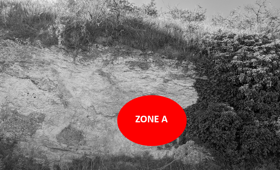
- Question 3 : Une petite grotte est visible sous la zone rouge A et on y voit un changement de coloration de la roche. Quelle est ce changement de coloration et à quoi est-il dû ?
- Question 3: A small cave is visible under the red zone A and we see a change in the color of the rock. What is this color change and what is it due to?
Point 2 : N 44° 19.468 E 000° 20.818'
Vous voici au soubassement de la croix au sommet du Pech au niveau de l'escalier (photo WP2).
Here you are at the base of the cross at the top of the Pech at the level of the stairs (photo WP2).

- Question 4 : décrivez les blocs de roche sous la zone bleue B (couleur, dureté, texture) et déduisez en sa nature dans la Trilogie Agenaise.
- Question 4: describe the blocks of rock under blue zone B (color, hardness, texture) and deduce its nature in the Agenaise Trilogy.
- Question 5 : en observant de près les blocs, vous pouvez noter des motifs particuliers. De quoi s'agit-il ?
- Question 4: by observing the blocks closely, you can notice particular patterns. What is it about ?
Point 3 : N 44° 19.469 E 000° 20.808'
Vous voici devant le panorama offert par la confluence du Lot et de la Garonne.
Here you are in front of the panorama offered by the confluence of the Lot and the Garonne.
- Question 0 : Prenez une photo de vous ou d'un élément vous appartenant avec avec la Confluence en arrière plan.
Cette photo devra au choix nous être transmise avec les réponses ou être ajoutée à votre log.
-Question 0 : Take a picture of yourself or something belonging to you with the Confluence in the background.
This photo must either be sent to us with the answers or added to your log.
Vous voici aussi devant un panneau d'explication présentant l'origine du relief. Pas de question sur le panneau, mais sa lecture pourra vous permettre de comprendre l'origine de cette Confluence.
You are also in front of an explanation panel presenting the origin of the relief. No question on the panel, but reading it will allow you to understand the origin of this Confluence.
Vous pouvez vous loguer sans attendre notre confirmation,
mais vous devez nous envoyer les réponses en même temps soit par mail via notre profil (
fafahakkai), soit via la messagerie geocaching.com (Message Center).
S'il y a des problèmes avec vos réponses nous vous en ferons part.
Les logs enregistrés sans réponse seront supprimés.You can log this cache without waiting for our confirmation, but you must send us the answers at the same time, by e-mail via our profile (fafahakkai) or by the system of Message Center of geocaching.com.
If there is a problem with your answers we will notify you. The logs recorded without answers will be deleted.
Rappel concernant les « Earthcaches »: Il n'y a pas de conteneur à rechercher ni de logbook à renseigner. Il suffit de se rendre sur les lieux, de répondre aux questions ci-dessus et de nous renvoyer les réponses.
Reminder concerning "Earthcaches": there is neither a container to look for nor a logbook to sign. One need only go to the location, answer to the differents questions and send us the answers.