Skip to content

ClimateQuest - Volcano under the water Multi-cache

Hidden : 6/15/2022
Difficulty:
3 out of 5
Terrain:
2 out of 5

Size: Size:   regular (regular)

Join now to view geocache location details. It's free!

Watch

How Geocaching Works

Please note Use of geocaching.com services is subject to the terms and conditions in our disclaimer.

Geocache Description:


Acest geocache face parte din jocul ClimateQuest, care te va călăuzi în unele zone umede interesante din România și îți va arăta efectele schimbărilor climatice, precum și efectele intervenției umane asupra acestor habitate.

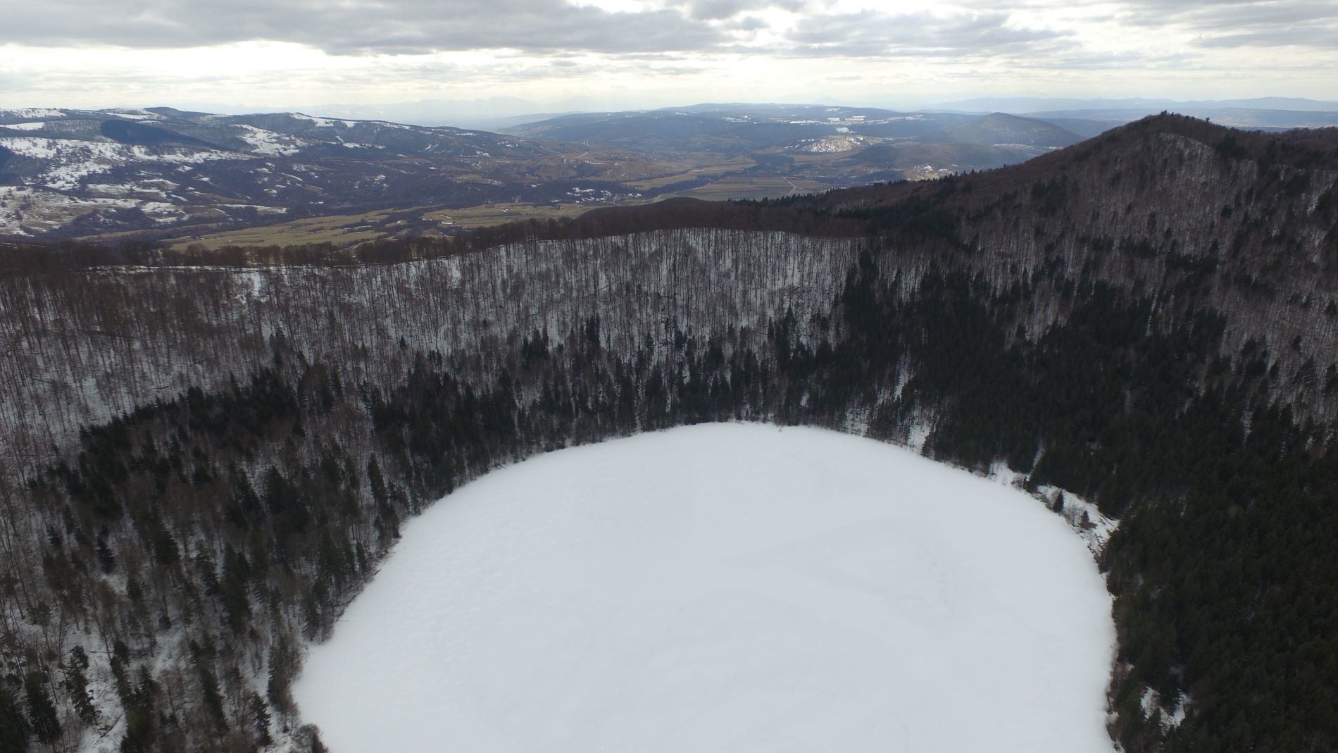
Lacul Sf. Ana este singurul lac vulcanic din Europa Centrală și de Est. Este situat într-una dintre cele două cratere din Masivul Ciomatu, iar în celălalt crater putem admira Tinovul Mohoș. Craterele fac parte din Rezervația Naturală Mohoș.

Unicitatea lacului constă în faptul că nu are izvoare, își completează apele doar prin precipitații. Ca urmare, aici s-a dezvoltat un sistem ecologic special, dar în același timp și foarte sensibil și fragil. Apa lacului se infiltrează în sol și iese în afara craterului sub formă de izvoare. Vechea legenda secuiască, care păstrează istoria formării și originea numelui, este o parte importantă a culturii transilvănene.

Acum 100-150 de ani, turiștii călătoreau să admire apa albastră ca cerul, aproape complet transparentă și adâncă de 12 metri. Dar astăzi, ecosistemul său sensibil este amenințat de numeroși factori.

În mod natural, lacul se umple încet-încet cu resturi vegetale, dar acest proces s-a accelerat în ultima vreme datorită activității umane. În plus, adâncimea sa a scăzut semnificativ și, ca urmare, în următorii 300 de ani se poate transforma într-o mlaștină.

Din păcate, și calitatea apei se deteriorează semnificativ. Unul dintre motive este dezvoltarea masivă a algelor verzi în apă, datorită  cantității imense de azot și fosfor apărută în lac, ca urmare a intensificării turismului.  De asemenea, culoarea cristalină a lacului s-a schimbat în verde, reducând în mare măsură și transparența acestuia. În plus, creșterea numărului de pești populați în lac, reprezintă o amenințare considerabilă în această zonă umedă.

Ce putem face pentru a îmbunătăți calitatea apei?

  • Scăldatul este interzis din 2018. Respectă această regulă!
  • În timpul vizitei, utilizează numai drumul asfaltat și nu potecile din pădure. Lărgirea potecii poate contribui la eroziunea solului, iar acesta va accelera procesele de umplere al lacului.
  • Folosește numai facilitățile de toaletă desemnate, prevenind astfel scurgerea a mai mult azot și fosfor în apă și împiedicând astfel amplificarea proceselor de eutrofizare.

Prezența urșilor este aproape zilnică în această zonă, ei sunt obișnuiți cu prezența oamenilor și caută hrană în coșurile de gunoi. Prin urmare, îți recomandăm să vizitezi cache-ul doar în timpul zilei și de preferat în grup, împreună cu alte persoane.

STAȚIA 1

Jocul începe aici: N 46° 7.9267 E 25° 53.765'

După ce ți-ai parcat mașina, uită-te pe harta așezată lângă căsuță. 

Pentru a găsi geocache-ul, înlocuiește literele "a", "b", "c" cu numerele corespunzătoare în următoare coordonate: N 46° 7.ab0 E 25° 53.c0a . Vei găsi răspunsurile pe hartă.

a: Care este adâncimea maximă actuală a lacului? (Rotunjește numărul)

b: Caută pe hartă vârful Ciumatul Mic. Care este cea de-a patra cifră a altitudinii sale?

c: Caută pe hartă vârful Ciumatul Mare. Uită-te la înălțimea lui și adună primele două cifre.


Ez a geoláda a ClimateQuest játék része. A játék elvezet téged Románia különböző vizes élőhelyeire és bemutatja a klímaváltozást és emberi beavatkozások ott tapasztalható hatásait.

A Szent Anna-tó Közép-Kelet-Európa egyetlen épen megmaradt vulkáni tava. A tó a két ikerkráter egyikében fekszik, míg a másikban a már feltöltődött Mohos-tőzeglápot lehet megcsodálni. A két kráter a Csomád hegység-részét képezi, és a Mohos Természetvédelmi Terület része.

A tó különlegessége, hogy nincs befolyó forrása, így csapadékvízből táplálkozik. Ennek köszönhetően egyedülálló, de érzékeny ökológiai rendszere alakult ki. A tó vize a mederből a talajba szivárog, és források formájában bukkan fel helyenként a kráteren kívül. Ásványi anyag tartalma igen alacsony, ezért élővilága szegényes. A kialakulásának történetét és nevének eredetét őrző ősi székely legenda fontos részét képezi az erdélyi kultúrának.

A 100-150 éve még égszínkék, 12 méter mély, szinte teljesen átlátszó vize elkápráztatta az idelátogatókat. Viszont érzékeny ökológia rendszerét számos tényező veszélyezteti. Az emberi tevékenység következtében felgyorsult feltöltődés miatt hajdani mélysége jelentősen csökkent, és ennek következtében akár háromszáz éven belül a tó helyén tőzegláp alakulhat ki. Sajnos, vizének minősége is egyre romlik. Ennek egyik oka a zöldalgák elszaporodása a vízben. Ezt a turizmus fellendülése következtében megnövekedett nitrogén és foszfor mennyisége eredményezte. A zöldalgák jelenléte miatt, az égszínkék víz zöldre változott és átlátszósága is nagyon lecsökkent. Emellett a betelepített halak túlszaporodása is veszélyezteti ezt a vizes élőhelyet.

Mit tehetünk azért, hogy javulhasson a tó vizének minősége?

  • 2018 óta tilos a fürdőzés. Tartsuk tiszteletben ezt a szabályt!
  • Látogatáskor kizárólag az aszfalt utat használjuk és ne térjünk le az erdőben kitaposott ösvényekre, mert az ösvény kiszélesítése is elősegítheti a talaj lemosódását és felgyorsítja a tó feltöltődési folyamatát.
  • Csak a kijelölt illemhelyeket használjuk, ezzel is meggátolva, hogy még több nitrogén és foszfor szivárogjon a tóba, amelyek az eutrofizációs folyamatokat erősítik.

A környéken szinte mindennapos az embertől nem idegenkedő, szemetesekre járó medvék megjelenése. Ezért azt ajánljuk, hogy sötétedés után ne látogasd a geoládát, de világosságban is inkább többedmagaddal érdemes elindulni  az útra.

1. ÁLLOMÁS

A játék itt kezdődik: N 46° 7.9267 E 25° 53.765'

Miután leparkoltad az autót, figyeld meg alaposan az információs házikó melletti térképet.

Ahhoz, hogy megtaláld a geoládát az "a", "b", "c" betűket helyettesítsd a megfelelő számokkal az alábbi koordinátában: N 46° 7.ab0 E 25° 53.c0a . A válaszokat megtalálod a térképen.

a: Mekkora a tó jelenlegi legnagyobb mélysége? (Kerekítsd le a számot)

b: Keresd meg a Kis-Csomád csúcsot a térképen. Mi a magasságának negyedik számjegye?

c: Keresd meg a Nagy-Csomád hegycsúcsot a térképen, magasságának első két számjegyét add össze.


This geocache is part of the ClimateQuest game, which will guide you around some interesting wetlands in Romania and show you the effects of climate change, as well as the effects of human intervention on these habitats.

Lake Sfânta Ana (lit. Saint Anne Lake) is the only crater lake remained in Central and Eastern Europe. It is located in one of the two volcanic craters in the Ciomatu Massif, and in the other crater we can admire Tinovul Mohoș. The craters are part of the Mohoș Nature Reserve.

The uniqueness of the lake lies in the fact that it has no springs, it is supplied exclusively with precipitation. As a result, a special ecological system has been developed here, but at the same time a very sensitive and fragile ecosystem. The lake's water seeps into the ground and comes out of the crater in the form of springs. The old Szekler legend, which preserves the history of the formation and the origin of the name, is an important part of the Transylvanian culture.

100-150 years ago, many tourists traveled to admire its sky-blue, almost completely transparent and 12 meters deep water. But today, its sensitive ecosystem is threatened by many factors.

As part of the natural process, the lake is slowly filling up with plant debris, but this process has accelerated lately due to human activity. In addition, its depth has decreased significantly, and as a result, it can turn into a swamp in the next 300 years.

Unfortunately, there is a significant deterioration in the water quality also. One of the reasons is the massive development of green algae in the water, due to the huge amount of nitrogen and phosphorus that appeared in the lake, as a result of the growing tourism. Also, the crystalline color of the lake has changed to green, greatly reducing its transparency. In addition, the increase in the number of fish introduced into the lake is a significant threat in this wetland.

What can we do to improve water quality?

  • Bathing has been banned since 2018. Follow this rule!
  • During the visit, use only the paved road and not the forest paths. The widening of the path can contribute to soil erosion, and it will accelerate the filling processes of the lake.
  • Use only designated toilet facilities, thus preventing more nitrogen and phosphorus from leaking into the water and preventing the amplification of eutrophication processes.

The presence of bears is almost daily in this area, they are used to the presence of people and look for food in the trash. Therefore, we recommend that you visit the cache only during the day and preferably in a group with other people.

STAGE 1

Your game starts here: N 46° 7.9267 E 25° 53.765'

After you have parked your car, look at the map next to the house.

To find the geocache, replace the letters "a", "b", "c" with the corresponding numbers in the following coordinates: N 46° 7.ab0 E 25° 53.c0a . You will find the answers on the map

a: What is the actual maximum depth of the lake? (Round the number)

b: Find the peak of Ciumatul Mic on the map. What is the fourth digit of its altitude?

c: Search the map for Ciumatul Mare. Look at its altitude and add the first two digits.


Additional Hints (Decrypt)

Jbbqra arfg obk uggc://jjj.trbpurpxre.pbz/vaqrk.cuc?pbqr=121327084n973o23r2s34q0n6sq209rr&npgvba=purpx&jc=47433957335938&anzr=436p696q6174655175657374202q20566s6p63616r6s20756r64657220746865207761746572

Decryption Key

A|B|C|D|E|F|G|H|I|J|K|L|M
-------------------------
N|O|P|Q|R|S|T|U|V|W|X|Y|Z

(letter above equals below, and vice versa)