

Introduction
Dans l’Earthcache voisine (GC7GMF2), que je vous conseille, vous allez pouvoir approfondir vos connaissances sur les terrils.
Dans celle-ci, nous allons plutôt évoquer l’anthropocène et ses paysages.
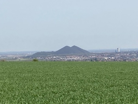
Les deux terrils jumeaux de Loos-en-Gohelle qui culminent à 186 m d'altitude, constituent des marqueurs paysagers dominant la partie centrale du bassin houiller. On remarque au premier plan le caractère fortement agricole d'une partie des paysages du bassin.
L’anthropocène: quesaco ?
Il y a tout juste vingt ans, le prix Nobel de chimie Paul Crutzen proposait de désigner l’époque contemporaine par le terme d’Anthropocène. Depuis la fin du 19ème siècle, constatait-il, l’action humaine sur son environnement est devenue si lourde que « le climat de la Terre pourrait dériver significativement de son régime naturel pour les millénaires à venir ».
En faisant de l’invention de la machine à vapeur le symbole de cette transition, Crutzen établit une analogie entre l’Anthropocène et la période géologique précédente. Au temps de l’Holocène, la « révolution agricole » rendue possible par le climat tempéré a engendré la civilisation néolithique ; l’entrée dans l’Anthropocène est causée par la « révolution industrielle » et donne naissance à notre civilisation productiviste et urbaine où l’énergie a une place prépondérante.
Durant cette nouvelle ère géologique, l’homme agit sur son environnement pour le transformer. Tout le monde a en tête le réchauffement climatique mais il y a bien d’autres aspects qui peuvent être cités. En voici quelques uns.
La modification du paysage liée à l’exploitation des ressources
Dans cette catégorie, il y a de nombreux exemples qui peuvent illustrer l’anthropocène.
On peut citer les carrières dont certaines sont si grandes qu’elles se voient dans les photos satellites. C’est le cas de la carrière de Marquise dans les Hauts de France (près de la côte d’Opale).
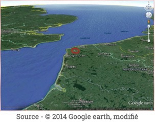
La petite tache blanche au centre du cercle rouge correspond aux carrières exploitant le Paléozoïque local, dont les Carrières de Marquise (Nord Pas de Calais). Le fait que ces carrières soient visibles sur une photo à cette échelle montre bien leur importance.
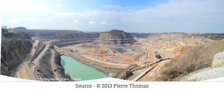
Il s'agit de la plus grande carrière de France, avec une emprise d'environ 2500 x 1500 m et une profondeur de 150 m. L'altitude moyenne du secteur étant d'environ 60 m, le point le plus bas de la carrière est donc à -90 m sous le niveau de la mer. Un certain nombre de camions donnent une idée de la taille de la carrière (chaque camion peut transporter 100 t de roche).
Il y a aussi l’exploitation du charbon. Dans la région, les terrils constituent un nouveau paysage du bassin minier.
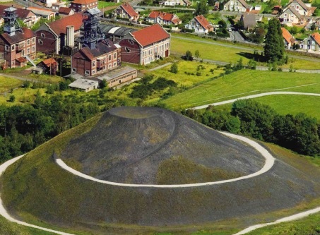
Les terrils sont issus de l’accumulation des roches stériles sorties des galeries de mine lors de l’exploitation du charbon et déposées à proximité du puits d’extraction.
Ils sont constitués de schistes et de grès avec une proportion de résidu de charbon qui a diminué au fil du temps et avec l’efficacité croissante des techniques d’exploitation.
Plats, tabulaires, tronqués ou coniques, leur forme raconte les techniques et les époques de mise en œuvre. Les plus anciens sont de taille modeste, à peine perceptibles, les plus récents occupent des surfaces et atteignent des hauteurs impressionnantes. Ils sont souvent associés à des bassins de décantation où étaient déposés les produits de lavage, les “schlamms”, qui constituent aujourd’hui des sols noirs où règne un micro-climat propice à une végétation atypique pour la région.
Les matériaux qu’ils contenaient, roches ou charbon, en fonction de l’évolution du contexte économique ont progressivement pris de la valeur et, après avoir lentement modifié l’horizon des habitants, beaucoup sont devenus des carrières à ciel ouvert et leur exploitation a bouleversé une fois encore le paysage.
Les sources bibliographiques
- http://geoconfluences.ens-lyon.fr/doc/transv/paysage/PaysageScient3.htm
- https://legrandcontinent.eu/fr/2022/02/08/le-croissant-fossile/
- https://anabf.org/pierredangle/dossiers/nord-pas-de-calais-une-terre-d-eau-et-de-feu/les-terrils-nouveau-paysage-du-bassin-minier
Pour valider la Earthcache
ATTENTION, vous êtes dans un lieu chargé d’histoire et protégé. Merci de le respecter et de ne pas le polluer.
Pour pouvoir valider cette EarthCache, vous devrez répondre correctement aux questions suivantes et ajouter à votre log une photo de vous, de votre GPS ou de votre pseudo au waypoint de la cache (OPTION). Cette photo permettra de valider le « trouvé » en cas de mauvaise réponse aux questions.
Merci d’envoyer vos réponses via mon profil ou via la messagerie geocaching.com, ne les donnez pas dans votre log. Les logs enregistrés sans réponses seront supprimés.
Vous pouvez loguer la cache "trouvé" sans attendre ma confirmation, je vous contacterai en cas de problème.
Rappel concernant les Earthcaches: Il n'y a pas de conteneur à rechercher ni de logbook à renseigner. Il suffit de se rendre sur les lieux, de répondre aux questions et de me renvoyer les réponses.
Question 1 : pouvez-vous citer des exemples qui illustrent l’anthropocène ?
Question 2 : sur le terrain, trouver du charbon encore présent dans la zone. Dire comment on le reconnaît par rapport aux autres roches que l’on peut observer.
Question 3 : décrire les lieux autour du PZ de la cache. A quoi servait la zone de creux à droite du PZ ?
Question 4 : pourquoi les terrils 19 et 19A devant vous n’ont plus la forme originale ?

Introduction
In the neighbouring Earthcache (GC7GMF2), which I recommend, you will be able to deepen your knowledge on the slag heaps.
In this one, we will rather evoke the anthropocene and its landscapes.
The two twin slag heaps of Loos-en-Gohelle, which reach an altitude of 186 m, are landscape markers dominating the central part of the coal basin. In the foreground, one can see the strongly agricultural character of part of the basin's landscapes.
Anthropocene: what is that ?
Just twenty years ago, Nobel Prize-winning chemist Paul Crutzen proposed to call the contemporary era the Anthropocene. Since the end of the 19th century, he noted, human action on the environment has become so heavy that "the Earth's climate could drift significantly from its natural regime for millennia to come.
By making the invention of the steam engine the symbol of this transition, Crutzen draws an analogy between the Anthropocene and the previous geological period. In the Holocene, the "agricultural revolution" made possible by the temperate climate gave rise to the Neolithic civilization; the entry into the Anthropocene is caused by the "industrial revolution" and gives rise to our productivist and urban civilization where energy has a predominant place.
During this new geological era, man acts on his environment to transform it. Everyone has in mind global warming but there are many other aspects that can be cited. Here are some of them.
Landscape modification related to resource exploitation
In this category, there are many examples that can illustrate the Anthropocene.
We can cite the quarries, some of which are so large that they can be seen in satellite photos. This is the case of the quarry of Marquise in the Hauts de France (near the Opal Coast).
The small white spot in the center of the red circle corresponds to the quarries exploiting the local Paleozoic, including the Marquise quarries (Nord Pas de Calais). The fact that these quarries are visible on a photo at this scale shows their importance.
It is the largest quarry in France, with an area of about 2500 x 1500 m and a depth of 150 m. The average altitude of the sector being about 60 m, the lowest point of the quarry is thus at -90 m under the sea level. A number of trucks give an idea of the size of the quarry (each truck can transport 100 t of rock).
There is also the exploitation of coal. In the region, the slag heaps constitute a new landscape of the mining basin.
The slag heaps are the result of the accumulation of waste rock from the mine galleries during coal mining and deposited near the extraction shaft.
They are made of shale and sandstone with a proportion of coal residue that has decreased over time and with the increasing efficiency of mining techniques.
Flat, tabular, truncated or conical, their shape tells the story of the techniques and the times of their implementation. The oldest ones are of modest size, hardly noticeable, the most recent ones occupy surfaces and reach impressive heights. They are often associated with decantation basins where the washing products, the "schlamms", were deposited. Today, they constitute black soils where a micro-climate reigns, favourable to a vegetation atypical for the region.
The materials they contained, rocks or coal, according to the evolution of the economic context, have progressively increased in value and, after having slowly modified the horizon of the inhabitants, many of them have become open-air quarries and their exploitation has once again upset the landscape.
To validate the Earthcache
ATTENTION, you are in a place full of history and protected. Please respect it and do not pollute it.
In order to validate this EarthCache, you will have to answer the following questions correctly and add to your log a photo of you, your GPS or your nickname at the waypoint of the cache (OPTION). This photo will validate the "found" in case of wrong answers to the questions.
Please send your answers via my profile or via the geocaching.com messaging system, do not give them in your log. The logs recorded without answers will be deleted.
You can log the "found" cache without waiting for my confirmation, I will contact you in case of problem.
Reminder about Earthcaches: There is no container to search or logbook to fill in. Just go to the location, answer the questions and send me back the answers.
Question 1 : Can you cite examples that illustrate the Anthropocene?
Question 2 : In the field, find coal still present in the area. Tell how it can be recognized in relation to other rocks that can be observed.
Question 3 : describe the area around the PZ of the cache. What was the purpose of the hollow area to the right of the PZ?
Question 4 : why the slag heaps 19 and 19A in front of you do not have the original shape anymore ?