
Les séries détritiques rouges de Fréhel et d'Erquy constituent, au flanc nord-ouest de la baie de Saint-Brieuc, des placages sub-continentaux d'âge précis encore discuté. Comprises entre les séries spilitiques d'Erquy d'âge finicambrien ou ordovicien inférieur, qu'elles recouvrent, et les filons doléritiques d'âge fini-dévonien, qui les recoupent, elles sont classiquement considérées comme homologues des formations rouges de Montmartin en Normandie, attribuées au Dévonien moyen sur critères micropaléontologiques (J. Doubinger et J. Poncet, 1964), mais homologues aussi des séries détritiques rouges de Plouézec - Plourivo sur le flanc ouest de la baie de Saint-Brieuc récemment datées à 472 ± 5 M.A., c'est-à-dire Ordovicien inférieur.
The red detrital series of Fréhel and Erquy constitute, on the north-western flank of the Bay of Saint-Brieuc, sub-continental veneers of a precise age that is still debated. Included between the Erquy spilitic series of Finicambrian or Lower Ordovician age, which they cover, and the doleritic veins of Fin-Devonian age, which cross them, they are classically considered as homologous to the red formations of Montmartin in Normandy, attributed to the Middle Devonian on micropalaeontological criteria (J. Doubinger and J. Poncet, 1964), but also homologous with the red detrital series of Plouézec - Plourivo on the western side of the Bay of Saint-Brieuc recently dated to 472 ± 5 M.A., i.e. Lower Ordovician.

Elles affleurent ici en deux compartiments distincts. Du cap d'Erquy à l'estuaire de l'Islet, les séries rouges complètes reposent sur la série spilitique d'Erquy. Plus à l'Est, seule la formation supérieure, dite de Fréhel, est représentée, recouvrant directement les diorites du horst de Plévenon et constituant les affleurements de Pléherel - Vieux-Bourg et du cap Fréhel.
They outcrop here in two distinct compartments. From the Erquy cape to the Islet estuary, the complete red series are based on the Erquy spilitic series. Further east, only the upper Fréhel formation is represented, directly overlying the diorites of the Plévenon horst and constituting the outcrops of Pléherel - Vieux-Bourg and Cap Fréhel.
 Formation de Fréhel / Formation of Fréhel
La formation de Fréhel surmonte en légère discordance la formation d'Erquy dont le sommet est marqué par une surface de ravinement. Plus importante par son épaisseur et par son extension que celle d'Erquy, elle recouvre tour à tour d'Ouest en Est la série rouge d'Erquy puis la série spilitique, et vers l'Est les diorites et les gneiss-dioritiques de Coëtmieux - Fort-la-Latte.
The Fréhel formation overlies the Erquy formation, the top of which is marked by a gully surface. It is thicker and more extensive than the Erquy Formation and covers the Erquy red series from west to east, then the spilitic series, and towards the east the diorites and diorite gneisses of Coëtmieux - Fort-la-Latte.
Lorsque son contact avec les séries sous-jacentes est visible, la formation de Fréhel débute par un niveau de 1 mètre environ de conglomérat à éléments pluricentimétriques et à matrice schisto-argileuse très friable et de couleur verdâtre. A ce premier niveau succèdent 8 à 10 mètres de conglomérat à galets décimétriques de composition phtanitique, quartzitique et volcanique.
When its contact with the underlying series is visible, the Fréhel formation begins with a level of approximately 1 metre of conglomerate with multi-centimetre elements and a very friable, greenish schisto-clay matrix. This first level is followed by 8 to 10 metres of conglomerate with decimetric pebbles of phtanitic, quartzite and volcanic composition.
La matrice de ce conglomérat rouge est schisto-gréseuse à la base et devient de plus en plus gréseuse et même quartzitique vers le sommet. Dans l'anse des Sévignés, les éléments du conglomérat, aux contours anguleux, peuvent atteindre 1 m 3 vers la base; mieux calibrés, bien roulés, ils ont une taille décimétrique au sommet de cet horizon.
The matrix of this red conglomerate is schistosandstone at the base and becomes increasingly sandstone and even quartzite towards the top. In the Sévignés cove, the conglomerate elements, with angular contours, can reach 1 m 3 towards the base; better calibrated, well rolled, they have a decimetric size at the top of this horizon.
A ce conglomérat succèdent 60 à 80 mètres de grès silicifiés à intercalation d'horizons discontinus de conglomérat. Ce grès très feldspathique est fréquemment kaolinisé vers sa base (Nord d'Erquy et de Pléhérel). La formation de Fréhel se termine par les grès de Fréhel, feldspathiques, grossiers et silicifiés.
This conglomerate is followed by 60 to 80 metres of silicified sandstone interspersed with discontinuous horizons of conglomerate. This very feldspathic sandstone is frequently kaolinised towards its base (north of Erquy and Pléhérel). The Fréhel formation ends with the Fréhel sandstone, feldspathic, coarse and silicified.
Répartition des sédiments et caractéristiques hydrodynamiques / Sediment distribution and hydrodynamic characteristics
Les cailloutis sont très largement répartis couvrant de vastes surfaces depuis la partie médiane de la feuille, au Nord du cap Fréhel, jusqu'au cap d'Erquy à l'Ouest. Dans cette zone caillouteuse la couverture meuble est mince et fréquemment interrompue de pointements ou de platiers rocheux.
The pebbles are very widely distributed, covering vast areas from the median part of the sheet, north of Cape Fréhel, to Cape Erquy in the west. In this stony zone the loose cover is thin and frequently interrupted by rocky points or flats.
Des graviers apparaissent à l'Ouest et au Sud-Est passant à des sédiments sableux, localement vaseux dans les anses côtières et les baies : baie de Saint-Brieuc, baie de la Fresnaye, baie de l'Arguenon, baie de Lancieux.
Gravels appear to the west and south-east, changing to sandy, locally muddy sediments in the coastal coves and bays: Saint-Brieuc Bay, Fresnaye Bay, Arguenon Bay, Lancieux Bay.
Cette distribution des sédiments résulte de l'action des courants de marée dont les vitesses, particulièrement élevées au large du cap Fréhel (de l'ordre de 3 noeuds en vives eaux), diminuent, d'une part vers la baie de Saint-Brieuc, d'autre part vers les baies de la partie sud-est de la feuille. On retrouve là un schéma classique en Manche montrant des enchaînements sédimentaires à granulométrie décroissante en fonction de l'énergie de plus en plus faible du milieu.
This distribution of sediments is the result of the action of tidal currents whose speeds, particularly high off Cape Fréhel (of the order of 3 knots in spring tide), decrease, on the one hand towards the bay of Saint-Brieuc, and on the other hand towards the bays of the south-eastern part of the sheet. This is a classic pattern in the Channel, showing sedimentary sequences with decreasing granulometry as a function of the decreasing energy of the environment.
La frange côtière est soumise à l'action des houles, d'autant plus efficaces que le rivage est plus exposé aux vents du large et que la tranche d'eau est mince. Les zones très battues comme les abords du cap Fréhel ne comportent pas de sables; les sédiments caillouteux qui s'étalent entre les rochers s'avancent jusqu'au rivage.
The coastal fringe is subject to the action of swells, which are all the more effective as the shoreline is more exposed to offshore winds and the water is thinner. The heavily battered areas such as the approaches to Cap Fréhel have no sand; the stony sediments that spread out between the rocks reach the shore.

Dans les baies ouvertes, le tri du matériel conduit en haut de plage à des sables grossiers ou graveleux bordés de dunes ou à un cordon de galets généralement appuyé à une falaise. Par dérive littorale les galets peuvent alimenter des cordons longeant le pied des dunes (région d'Erquy par exemple). Les dépôts s'affinent vers le bas estran et la plage sous-marine où s'accumulent des sablons, voire des sables vaseux.
In open bays, the sorting of the material leads to coarse or gravelly sand at the top of the beach, bordered by dunes or a pebble beach, generally supported by a cliff. By littoral drift, the pebbles can feed the strips along the foot of the dunes (Erquy region for example). The deposits are refined towards the low foreshore and the underwater beach where sand and even muddy sand accumulate.
Dans les parties abritées du littoral comme la baie de la Fresnaye, les houles n'assurent pas le relais des courants de marée, les sédiments deviennent de plus en plus fins du large vers l'intérieur en fonction de l'énergie décroissante du milieu. On aboutit, au fond de la baie qui se colmate, à un schorre installé sur des sédiments vaseux présentant fréquemment une structure litée due au rythme des marées.
In the sheltered parts of the coastline, such as the bay of La Fresnaye, the swells do not ensure the relay of the tidal currents, the sediments become increasingly fine from the open sea inwards according to the decreasing energy of the environment. The result, at the bottom of the bay, which becomes clogged, is a schorre installed on muddy sediments which often have a bedded structure due to the rhythm of the tides.

Grève de galets / Pebble beach
Une grève (du bas latin grava, « gravier ») est un espace d'échouage en bord de mer fait de sable, de graviers ou de galets. Un galet est un fragment de roche à l’aspect arrondi et lisse, engendré par usure mécanique et formé par le mouvement des eaux. Les galets sont de différentes couleurs et textures et peuvent avoir des stries, appelées veines, de quartz ou d'autres minéraux. Les galets sont pour la plupart lisses mais, en fonction de la fréquence à laquelle ils entrent en contact avec la mer, ils peuvent avoir des marques de contact avec d'autres roches ou d'autres cailloux et ainsi être plus arrondis.
Les galets laissés au-dessus de la ligne des hautes eaux peuvent avoir des excroissances d'organismes tels que le lichen, ce qui signifie l'absence de contact avec l'eau de mer.
A shoreline (from the Latin grava, "gravel") is an area of beachfront made of sand, gravel or pebbles. A pebble is a smooth, rounded piece of rock, created by mechanical wear and formed by the movement of water. Pebbles come in different colours and textures and may have streaks, called veins, of quartz or other minerals. Pebbles are mostly smooth but, depending on how often they come into contact with the sea, they may have contact marks with other rocks or pebbles and thus be more rounded.
Pebbles left above the high water mark may have growths of organisms such as lichen, which means no contact with sea water.
Pour valider cette earthcache / To validate this earthcache
Rendez-vous aux coordonnées de cette earthcache (ainsi qu'au différents waypoints) et répondez aux questions suivantes :
Go to the coordinates of this earthcache (and the various waypoints) and answer the following questions:
Question 1 : Aux coordonnées - N 48° 38.944' W 2° 25.627' - quelle formation pouvez-vous observer. Est-ce un rocher, un bloc, des galets ou du sable ?
Question 1: At the coordinates - N 48° 38.944' W 2° 25.627' - what formation can you see. Is it a rock, a boulder, pebbles or sand?
Question 2 : Au waypoint 2 - N 48° 38.940' W 2° 25.630' - sur quel type de formation vous trouvez-vous ? D'après les informations que vous pouvez trouver sur cette page comment s'est formée cette formation ? En observant attentivement sur place, est-ce que cette zone est en contact avec la mer ?
Question 2: At waypoint 2 - N 48° 38.940' W 2° 25.630'- what type of formation are you on? According to the information you can find on this page, how was this formation formed? If you look carefully at the spot, is this area in contact with the sea?
PHOTO : Au waypoint 3 - N 48° 38.952' W 2° 25.639'- prenez une photo de vous (de votre pseudo sur votre main ou d'une de vos objets geocaching) avec le rocher en arrière plan. Attention cette photo est OBLIGATOIRE pour valider votre découverte.
PHOTO: At waypoint 3 - N 48° 38.952' W 2° 25.639'- take a photo of yourself (of your nickname on your hand or of one of your geocaching objects) with the rock in the background. Please note that this photo is MANDATORY to validate your discovery.
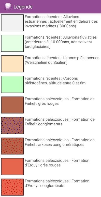
Question 3 : Au waypoint 3 - N 48° 38.952' W 2° 25.639'- en vous appuyant sur les informations présentées sur cette page et la légende pouvez-vous indiquer de quelle formation géologique est ce rocher ?
Question 3: At waypoint 3 - N 48° 38.952' W 2° 25.639'- based on the information presented on this page and the legend can you indicate which geological formation this rock is from?
Pour rappel dans les earthcaches il n'y a pas de boîte à trouver. Il vous faut juste vous rendre sur place et répondre aux questions d'observation qui vous sont posées.
Loguez cette cache "Found it" et envoyez-moi vos propositions de réponses soit via mon profil, soit via la messagerie geocaching.com (Message Center), et je vous contacterai en cas de problème. Attention la photo est OBLIGATOIRE pour valider votre découverte, incluez là dans votre log, sans cette photo votre log sera effacé !
As a reminder in the earthcaches there is no box to find. You just have to go there and answer the observation questions that are asked of you.
Log this "Found it" cache and send me your suggestions for answers either via my profile or via the geocaching.com messaging system (Message Center), and I will contact you in case of problems. Be careful, the picture is MANDATORY to validate your discovery, include it in your log, without this picture your log will be deleted !
Sources : Carte géologique de la France à 1 / 50 000 # Saint-Cast / Wikipedia / Geoforum