Key Feature:
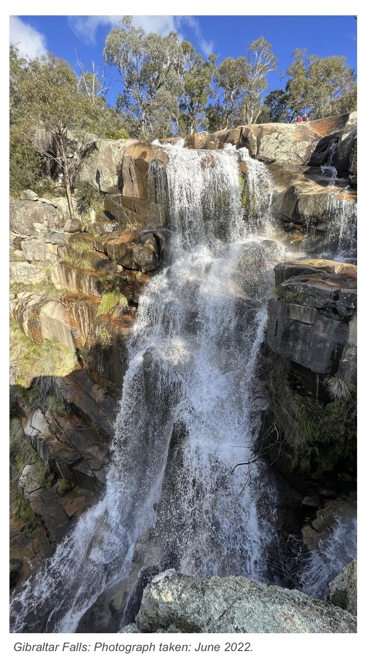
GIBRALTAR FALLS: is one of the widest, highest and most accessible waterfalls in the ACT. The Gibraltar Creek descends a vertical distance of 50 metres by a series of steep cascades (short and long waterfalls). It enters a granite-walled gorge that extends for 800 metres through to Woods Reserve below. At the head of the falls the creek is approximately four metres wide in a shallow rock-floored valley. The creek plunges over the rim of the falls via narrow meandering gutters eroded in the granitic rock.
Background:
We acknowledge the Ngunnawal people as traditional custodians of this region. The area around Gibraltar Falls in the Tidbinbilla region, in the Namadgi National Park, has significant heritage value having been an important location for the Ngunnawal inhabitants. A rock shelter, axe grinding grooves and stone artifact scatters in the area show a long history of indigenous inhabitations of the Gibraltar Valley.
European settlement in the area first occurred in the 1880's by the Woods family. They called their property 'Gibraltar Creek'. Until the Corin Dam Road was built in the 1960's the property and the falls were difficult to access.
Geology:
The main type of GRANITE that formed in this region is SHANNONS FLAT ADAMELLITE from the late SILURIAN PERIOD.
To put this geologic period into context the Earth is about 4500 million years old. About 10 times older than the oldest rocks in the Tidbinbilla region. About 450 to 500 million years ago during the ORDOVICIAN PERIOD this area was covered by shallow seas. Sand and other sediments were washed in from surrounding areas and deposited on the sea floor. During the Silurian Period 400 to 450 million years ago this area was LIFTED ABOVE SEA LEVEL at the same time massive volcanic activity injected MAGMA into the sediments deep below ground. Over the next 400 million years seas washed back in the valleys, several glaciers came and went and there were significant earthquakes.
However, it is thought that the uplifted peaks around the Tidbinbilla region remained well above sea level during this time being continually eroded away. Through millions of years of erosion sediments (SANDSTONE) that covered the magma (GRANITE) was eventually exposed at the surface. As a result, the creek bed above the falls, the falls themselves, and the gorge and creek bed below are all composed of granite.
Standing at the Gibraltar Falls lookout you can see that the exposed granite is breaking up into seemingly large blocks. This is a result of MECHANICAL and CHEMICAL WEATHERING working together above and below the surface. Mechanical weathering here is the result of ongoing seasonal freezing and thawing, heating and cooling, wetting and drying, wind and water. There is also biological activity and the influences of gravity. Chemical weathering is also occurring at the rock boundaries and in the cracks with water and biological agents dissolving the minerals and salts in the granite. The rate of weathering varies as the intensity of the wind, the volume of water, and biological and chemical activity differs on each of the granite surfaces.
Flora and Fauna:
The cool, moist atmosphere in the splash zones of the falls has allowed the growth of rare ferns, Black She-oak, Varnish Wattle and Bossiaea. The ferns and mosses on the rock faces of the falls are the habitat of the Waterfall Redspot Dragonfly.
Access:
Stage 1: (Carpark) There is a well-formed road to the tarred carpark. The carpark joins directly to the gravel tracks leading to Stages 2 & 3. After parking proceed to Stage 2: to answer the first question.
Stage 2: A gravel track straight through from the carpark, approximately a 30 metre walk, leads to a narrow bridge that crosses Gibraltar Creek. This bridge is approximately 60 metres up from the falls. Here, standing in the centre of the bridge, you will have spectacular views of the 'infinity pool' and the mountains beyond.
Stage 3: Another gravel track, left from the end of the carpark, provides access down to steep stairs to the viewing platform less than 100 metres away.
Logging Requirements:
To log this cache you will need to address the following 5 points (questions and mandatory photo).
Please send your answers via 'Message Center' to either CO. You can log this cache immediately attaching your photo/s. If there are issues with your answers or photo you will be notified.
Questions / Photo:
Stage 2: Gibraltar Creek metal bridge crossing – above the cascades:
1. Stand in the centre of the bridge and look downstream. Why do you think that there is little visible sandstone? Multiple choice:
a) There was never much sandstone here to start with,
b) It takes a long time for granite to erode, and the sandstone is still to be exposed,
c) Erosion over millions of years has removed much of the sandstone that once lay above the granite.
Consider posting photos of yourself and/or the infinite pool.
Stage 3: Gibraltar Falls Viewing Platform – located below the commencement of the falls:
2. In what geologic period was the granite you see here today formed?
3. What kinds of weathering influences are at play at the falls today?
4. Cascades are visible at the top of the Gibraltar Falls. Why do you think that there are multiple falls here?
(Use text in the description above to formulate your answer, or do some of your own research.)
5. Post a photo of yourself, or something that identifies you with Gibraltar Falls in the background.
Consider posting photos that would encourage others to visit this beautiful location.