
click on the flag to reach the translation
Une Earthcache
Il ne s’agit pas d’une cache physique. Pour loguer cette cache, vous devez dans un premier temps prendre connaissance de sa description éducative en matière de géologie, puis d’observer le site sur lequel vous êtes, et enfin de répondre aux questions qui vous seront posées.
Vous pourrez alors loguer en "Found it" sans attendre mais vous devez me faire parvenir vos réponses en même temps en me contactant soit par mail dans mon profil, soit via la messagerie geocaching.com (Message Center), et je vous contacterai en cas de problème. Les logs enregistrés sans réponses seront supprimés.

Un peu de géologie
Une arène granitique
A l’échelle des temps géologiques, le granite peut se dégrader très rapidement d’autant plus que la vitesse de désagrégation du granit dépend du climat. L’altération du granite début généralement le long de fissures dans lesquelles l’eau pénètre. Dans un climat tempéré, elle conduit à la formation de boules de granite puis d’un chaos granitique avec la formation d’une arène granitique formée principalement de granis de quartz, mais aussi de micas altérés, de feldspaths pouvant évoluer jusqu’au stade d’argile kaolinique.
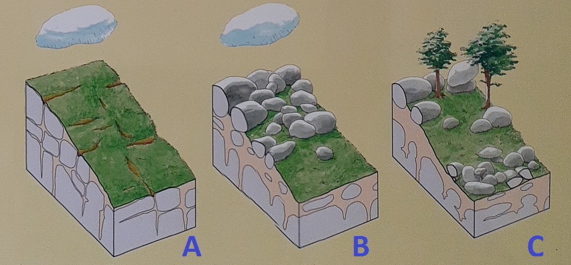 A) Granite sain fracturé recouvert d’un sol, infiltration d’eau de pluie dans les fractures du granite
B) Altération par l’eau du granite en arène granitique le long des fractures
C) Erosion et transport de l’arène par le ruissellement des eaux de pluie, les boules de granite restent sur place : formation d’un chaos granitique
Un peu de géomorphologie
La géomorphologie est la science qui a pour objet la description et l'explication des formes du relief terrestre.
- La météorisation, appelée aussi altération météorique, altération atmosphérique ou altération climatique, est l’ensemble des processus mécaniques, physico-chimiques ou biologiques de réduction élémentaire des roches et des minéraux à la surface de la Terre par les agents météoriques (appelés aussi météores, il s'agit principalement de l'eau, des gaz atmosphériques et des variations de température), mécaniques ou biologiques. Cette attaque de la roche en place s'effectue au contact de l'atmosphère ou à son voisinage, et les phénomènes météorologiques en contrôlent étroitement la marche. Aussi la qualifïe-t-on de météorisation, pour la distinguer de l'érosion qui implique un transport.
- Un chaos (de blocs ou de boules) désigne un modelé de déchaussement de blocs ou de rochers dégagés par l'érosion. Ces formes font partie des produits de la météorisation comme les tors (rochers en position de sommet ou de versant d'interfluve, à la différence du chaos en fond de vallée ou du champ de blocs en pied de falaise rocheuse ou entre les pointes rocheuses et les platiers), les arènes et à une échelle supérieure les inselbergs.
- Un tor désigne un modelé de déchaussement de blocs ou de rochers dégagés par l'érosion. Ce relief ruiniforme correspond généralement à des affleurements rocheux d'échelle décamétrique ou hectométrique, constitués par un empilement géométrique de blocs aux arêtes émoussées ou de forme ovoïde. Ces formes font partie des produits de la météorisation comme les arènes et à une échelle supérieure les inselbergs. Elles constituent un volume rocheux résiduel, enraciné, provenant principalement du dégagement partiel des produits meubles. Ces blocs sculptés par les agents météoriques selon des systèmes de diaclases subhorizontaux et subverticaux, donnent des reliefs qui surprennent par leurs arrangements défiant les lois de l'équilibre (typiquement les pierres branlantes) et leurs formes qui ont fécondé l'imaginaire populaire.
- Un inselberg ou monadnock est un relief (colline ou un petit massif) isolé qui domine significativement une plaine ou un plateau subhorizontal, sorte de "montagnes miniatures créées par l'érosion".
- Un talweg, ou thalweg, correspond à la ligne formée par les points ayant la plus basse altitude, soit dans une vallée, soit dans le lit d'un cours d'eau. Les talwegs sont en grande majorité modelés par l'érosion fluviale. Un interfluve est un relief compris entre deux talwegs; il est constitué de versants, séparés ou non par une surface plane.

Questions
Question 0 - Prenez une photo de vous, ou de votre objet distinctif de géocacheur, ou de votre pseudo écrit sur une feuille de papier ou dans votre main... au niveau du point zéro de cette earthcache (sans dévoilez l'observation qui suivra), et joignez-là à votre log ou à vos réponses
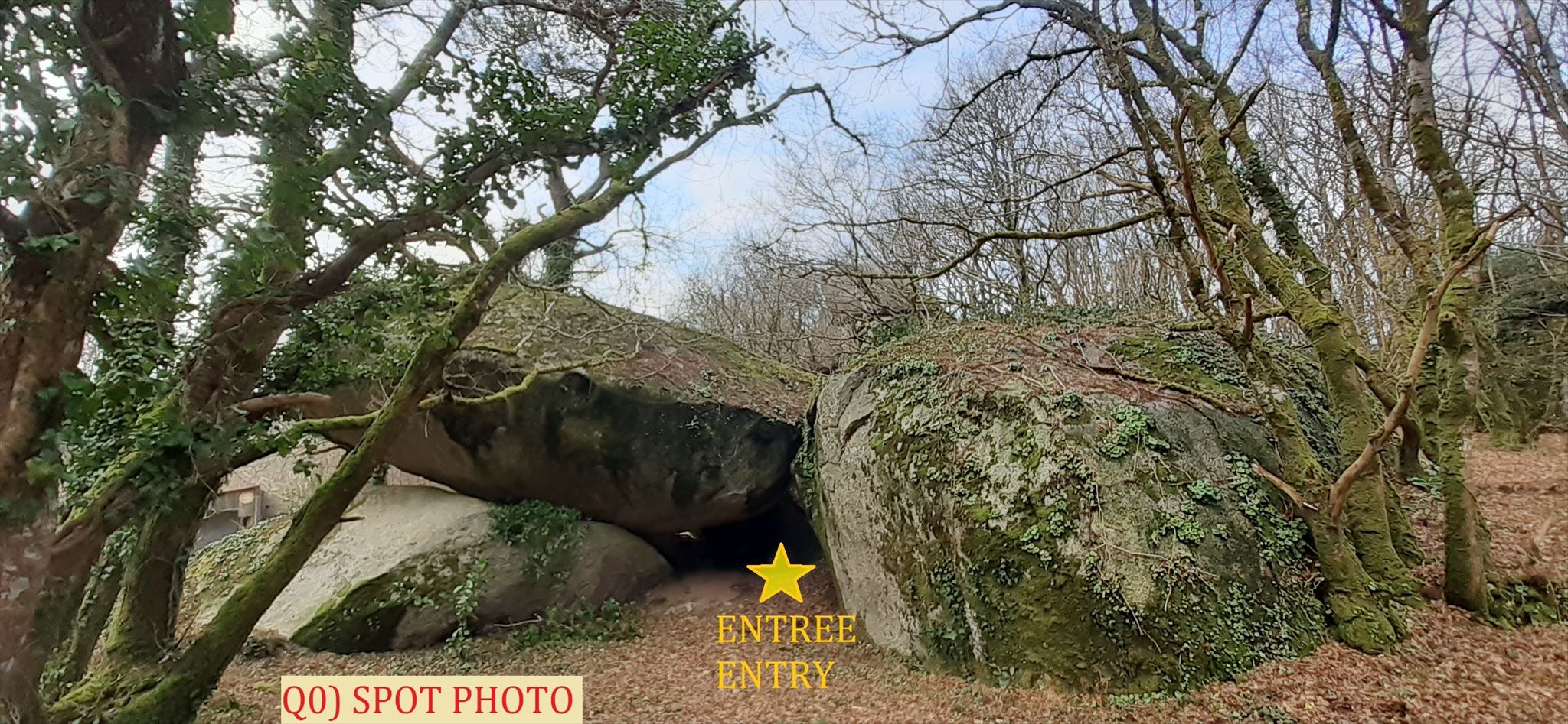
Point d'observation principal - Rendez-vous au point d'observation principal en passant par l'entrée entre les 2 blocs puis avancez sur 15m, circulez autour du phénomène géologique observé, attention où vous mettez les pieds
Question 1 - Décrivez la forme géologique que vous voyez devant vous
Question 2 - Selon vous, cette forme a été créé par:
- Obelix qui s'est amusé à faire un château de cartes
- Thor qui a frappé de son marteau ici
- Un résidu de météorite qui s'est fragmenté
- Un phénomène géologique naturel
Question 3 - Expliquez le phénomène géologique ici en présence.
Question 4 - Les blocs que vous voyez résultent-ils d'une érosion ou d'une météorisation (argumentez votre réponse) ?
Question 5 - Comment, en géomorphologie (cf leçon), pouvez-vous nommer la structure géologique face à vous ?

An Earthcache
It is not a physical cache. To log this cache, you must first learn about its educational description in geology, then observe the site on which you are, and finally answer the questions that will be asked.
You can then log in "Found it" without waiting but you must send me your answers at the same time by contacting me either by mail in my profile, or via the messaging geocaching.com (Message Center), and I will contact you in case of problem. Saved logs without answers will be deleted.
A little of geology
A granite arena
On the geological time scale, granite can degrade very quickly, especially since the rate at which granite disintegrates depends on the climate. Weathering of granite usually begins along cracks where water enters. In a temperate climate, it leads to the formation of granite balls and then to a granitic chaos with the formation of a granite arena formed mainly of quartz granis, but also of altered micas, feldspars that can evolve to the stage of kaolin clay.
A) Healthy fractured granite covered with soil, infiltration of rainwater into the granite fractures
B) Water alteration of granite in granite arena along the fractures
C) Erosion and transport of the arena by the runoff of rainwater, the granite balls remain in place: formation of a granite chaos
A bit of geomorphology
Geomorphology is the science which aims to describe and explain the forms of the earth's relief.
- Weathering, also called meteoric weathering, atmospheric weathering or climatic weathering, is the set of mechanical, physico-chemical or biological processes of elementary reduction of rocks and minerals on the surface of the Earth by meteoric agents (also called meteors, these are mainly water, atmospheric gases and temperature variations), mechanical or biological. This attack on the bedrock takes place in contact with the atmosphere or in its vicinity, and meteorological phenomena closely control its progress. It is therefore called weathering, to distinguish it from erosion which involves transport.
- A chaos (of blocks or balls) designates a pattern of loosening of blocks or rocks released by erosion. These forms are part of the products of weathering such as tors (rocks in the position of the summit or the slope of the interfluve, unlike the chaos at the bottom of the valley or the field of blocks at the foot of the rocky cliff or between the rocky points and the flats), the arenas and on a larger scale the inselbergs.
- A tor designates a model of loosening of blocks or rocks released by erosion. This ruiniform relief generally corresponds to rocky outcrops on a decametric or hectometric scale, consisting of a geometric stack of blocks with blunt edges or ovoid in shape. These forms are part of the products of weathering such as arenas and, on a larger scale, inselbergs. They constitute a residual rock volume, rooted, resulting mainly from the partial release of loose products. These blocks sculpted by meteoric agents according to systems of subhorizontal and subvertical joints, give reliefs which surprise by their arrangements defying the laws of balance (typically loose stones) and their shapes which have fertilized the popular imagination.
- An inselberg or monadnock is an isolated relief (hill or small massif) that significantly dominates a plain or a subhorizontal plateau, a kind of "miniature mountains created by the 'erosion'.
- A talweg, or thalweg, corresponds to the line formed by the points having the lowest altitude, either in a valley or in the bed of a course of water. The talwegs are mostly shaped by fluvial erosion. An interfluve is a relief between two thalwegs; it is made up of slopes, separated or not by a flat surface.
Questions
Question 0 - Take a picture of yourself, or your distinctive geocacher item, or your written nickname on a sheet of paper or in your hand... at the zero point of this earthcache (without revealing the observation that will follow), and attach it to your log or your answers
Main Observation Point - Get to the main observation point through the entrance between the 2 blocks then move forward 15m, circulate around the observed geological phenomenon, be careful where you step
Question 1 - Describe the geological shape you see in front of you
Question 2 - According to you, this form was created by:
- Obelix having fun making a house of cards
- Thor who struck his hammer here
- A meteorite residue that fragmented
- A natural geological phenomenon
Question 3 - Explain the geological phenomenon present here.
Question 4 - Are the blocks you see the result of erosion or weathering (argue your answer) ?
Question 5 - How, in geomorphology (see lesson), can you name the geological structure in front of you?