Vous vous trouvez au pied de la montagne de Remenot, devant une parcelle appelée Chaponnière. Au moment où on a nommé la parcelle ainsi, on avait dû planter des boutures de vignes qu’on appelle « chapons » en Bourgogne. Elles sont obtenues en coupant un sarment de plusieurs bourgeons sur la vigne-mère que l’on replantait directement en terre. Chaponnière était donc le lieu où l’on cultivait des chapons. Depuis la crise du phylloxéra à la fin du 19e siècle, on ne procède plus du tout de cette manière pour dupliquer la vigne : le sarment doit être greffé sur un porte-greffe (vigne américaine) résistant à l’insecte.
Les vignes sont des êtres vivants que nous vous demandons de respecter tout comme le paysage que nous partageons avec vous aujourd’hui.
(Le printemps est une période de traitement dans les vignes. Si un tracteur ou autre engin est en train de traiter quand vous arrivez dans la zone de la cache, nous vous conseillons de revenir plus tard)
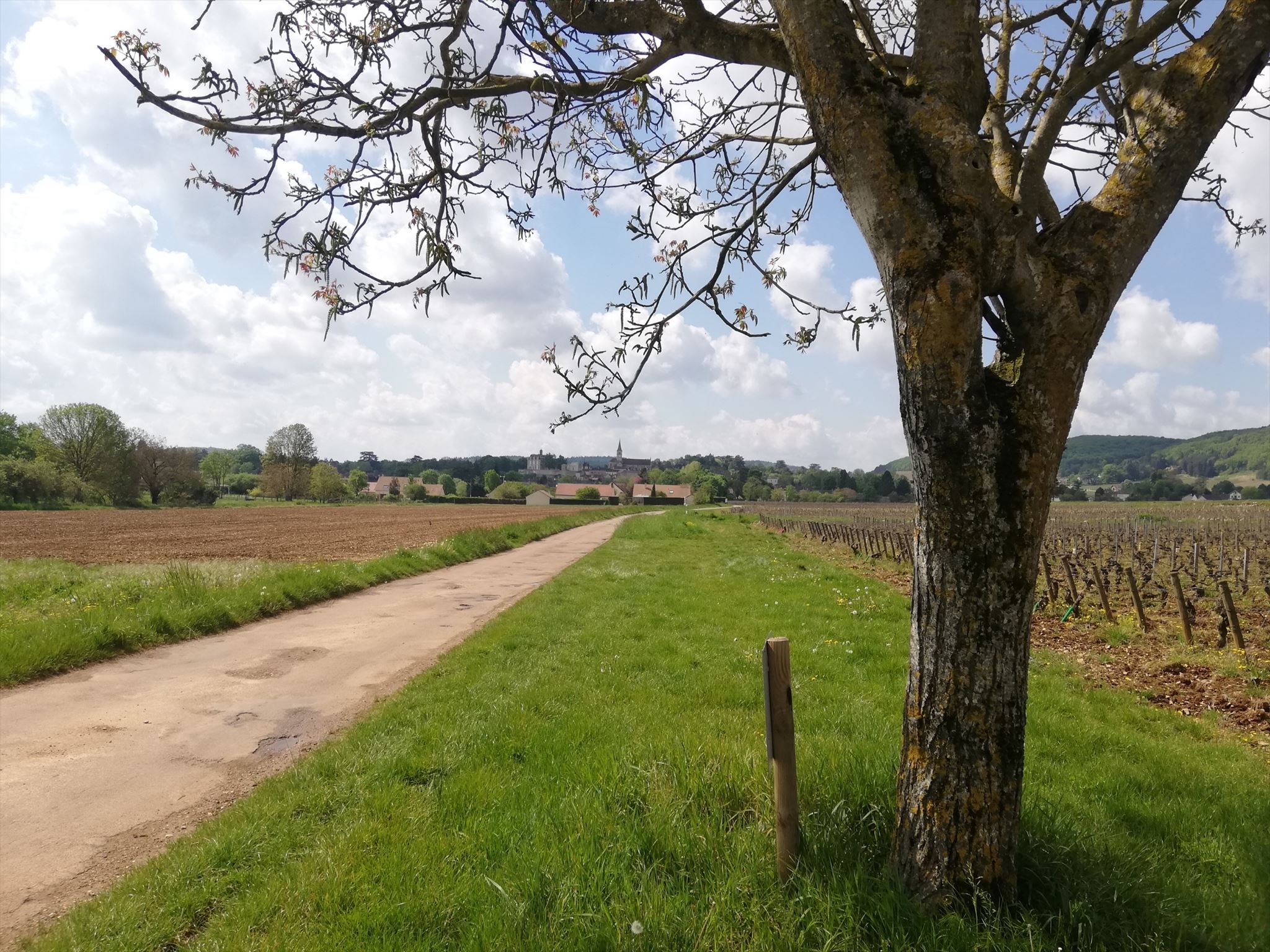
A = L’arbre devant vous, en bordure de vigne est un :
Cerisier : A = 6
Châtaigner : A = 7
Noisetier : A = 8
Noyer A = 9
B = Depuis Chaponnière, on a une vue splendide sur le village !
On voit l’église Saint-Laurent, B = 8
On voit le château Saint-Michel, B = 7
On voit l’église Saint-Laurent et le château Saint-Michel, B = 6
C = le nombre de ceps maximal que l’on peut compter dans la deuxième longueur de chaque rang.
Une « longueur » correspond à l’intervalle situé entre deux piquets.
D = le deuxième chiffre qui compose la date indiquée en bas à gauche du panneau qui se trouve près de l’arbre.
E = la troisième lettre du nom de la parcelle où vous vous trouvez (avec a = 1 et z = 26)
Etape finale :
N 46°52.XXX
E 4°44.YYY
Avec XXX = AAB
Et YYY = CDE
English
You are at the foot of the Remenot Mountain, in front of a plot called Chaponnière. When they gave the name to this plot (Chaponnière), the winegrowers were used to plant cuttings of grapevines that we call “chapon” in Burgundy in order to propagate the vineyard. They obtained the cuttings by cutting a branch with several buds from a mother plant, then they planted it directly in the ground. Therefor the Chaponnière was the place where we planted “chapons”. Since the phylloxera crisis at the end of the 19th century, we have stopped to plant the new baby gravines this way : the branch has to be graft on a roostock (American grapes), naturally resistant to the bug.
The vine grapes are living beings that we ask you to respect as the landscape we share with you today.
(Spring is a period for treatments in the vineyard. If you see a tractor or another machine treating when you arrived around the cache, we advise you to come back later)
A = The tree in front of you, at the border of the plot is a :
Cherry tree : A = 6
Sweet chestnut : A = 7
Hazel tree : A = 8
Walnut tree : A = 9
B= From Chaponnière, we have a gorgeous view on the village!
We see the church Saint-Laurent, B = 8
We see the château Saint-Michel, B = 7
We see the church Saint-Laurent and the château Saint-Michel, B = 6
C = the maximum number of grapevines you can count in the second length of each row. A “length” corresponds to the interval between each post.
D = the second number you can read in the date which figures at the left bottom of the sign close to the tree.
E = the third letter of the nam of the plot where you are (with a = 1 and z = 26)
Final stage :
N 46°52.XXX
E 4°44.YYY
With XXX = AAB
And YYY = CDE